Area Overview for SA34 0WU
Photos of SA34 0WU

Area Information
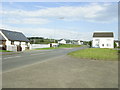
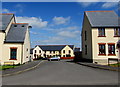
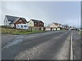
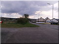
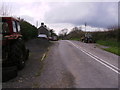
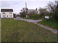
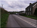
SA34 0WU defines itself as a specific postcode area covering a small residential cluster in Wales. You will live in a community of 2,381 people spread across a landscape with a density of 106 people per square kilometre. This figure places the area in a comfortable band for those seeking space without complete isolation, suggesting a compact settlement rather than a sprawling suburb. The location operates largely as a self-contained neighbourhood where daily life revolves around the immediate surroundings and nearby towns. For anyone considering living in SA34 0WU, the scale of the community is a primary feature of the experience. The area lacks the noise and congestion of larger urban centres, yet it retains enough population to support essential services nearby. Residents here know their neighbours, fostering a close-knit environment typical of smaller Welsh settlements. The character of the district is defined by its residential focus, offering a quiet lifestyle for families and retirees alike.
- Area Type
- Postcode
- Area Size
- Not available
- Population
- 2381
- Population Density
- 106 people/km²
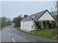
The housing stock in SA34 0WU is characterised by a strong presence of houses rather than flats or apartments. This preference for detached or semi-detached property aligns with the area's quiet, residential nature and the higher median age of its residents. With 72 per cent of homes owned outright, the market functions more on local sales than on investment rentals. You are unlikely to find a high volume of student lets or tourist accommodations in this specific cluster. Instead, the properties cater to individuals and families looking to settle in the region. This stability often means houses have been improved by multiple owners over time, potentially adding value and character. Buyers should expect a slower transaction process as the pool of potential homeowners is well-established. The lack of high-density blocks suggests that greenery and private land are common features of the property boundaries in this postcode.
House Prices in SA34 0WU
No properties found in this postcode.
Energy Efficiency in SA34 0WU
Daily life in SA34 0WU relies heavily on amenities located just beyond the immediate postcode boundary. Three railway stations are within practical reach, including Whitland Railway Station, Narberth Railway Station, and Clunderwen Railway Station. These hubs provide essential links to larger towns and cities, ensuring you are not cut off from regional employment or cultural opportunities. For daily shopping requirements, three retail outlets are accessible, specifically Co-op Whitland, Spar, and Co-op St. These shops offer the core necessities of food, fuel, and basic household goods without requiring a long journey to a town centre. The distribution of these amenities suggests a self-sufficient lifestyle where you do not need to venture far for basics. This arrangement supports a flexible routine where you can manage work, school runs, and leisure activities from a central home base.
Amenities
Schools
Families considering schools near SA34 0WU have three options listed in the local vicinity, though all are classified under the "other" category rather than standard primary or secondary designations. The nearest establishments include Henllan Amgoed C.P. School, Ysgol Llys Hywel, and Dyffryn Taf School. This grouping suggests a reliance on specific community-led or non-traditional educational models common in rural Wales. These institutions serve as the main focal points for local education rather than offering a wide mix of maintained nursery and comprehensive schools within immediate walking distance. Parents must check the specific intake ages and type of curriculum offered by each of these venues to ensure they match their children's needs. The naming suggests a connection to the historical and cultural heritage of the Aberdyfi valley, which may indicate a strong local governance structure for the education provided.
| Rank | School | Type | Entry gender | Ages |
|---|
Explore more schools in this area
Go to Schools tabDemographics
The community within SA34 0WU is older than the national average, with a median age of 47 years. Most residents fall into the adult age range between 30 and 64 years, indicating a population that balances active career years with retirement preparation. House ownership stands at 72 per cent, which is significantly higher than the typical rental-sharing models found in major cities. This high rate of ownership signals a stable demographic committed to long-term residence in their homes. The accommodation type is predominantly houses, matching the traditional architectural style of the region and the preference for single-family living. The predominant ethnic group is White, reflecting the broader demographic trends across much of Wales. This homogeneity contributes to a consistent community culture where traditions and local customs are easily maintained. There is little evidence of transient or short-term occupancy in this postcode.
Household Size
Accommodation Type
Tenure
Ethnic Group
Religion
Household Composition
Age
Household Deprivation
NS-SEC
Explore more demographic insights in this area
Go to Demographics tabPlanning
Planning Constraints
- Flood RiskPremium
- Ramsar Wetland SitesPremium
- Area of Outstanding Natural BeautyPremium
- Protected Nature ReservePremium
- Protected WoodlandPremium
- Crime RiskPremium