Area Overview for SA34 0RY
Photos of SA34 0RY
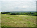
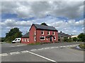
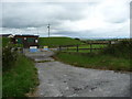
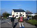
5 photos from this area
Area Information
Key information about the SA34 0RY including its size, population, and administrative classification.
- Area Type
- Postcode
- Area Size
- 31.6 hectares
- Population
- 2097
- Population Density
- 21 people/km²
House Prices in SA34 0RY
8
Properties
£301,667
Average Sold Price
£77,000
Lowest Price
£736,000
Highest Price
Showing 8 properties
| Address | Type | Beds | Baths | Last Sale Price | Last Sale Date | |
|---|---|---|---|---|---|---|
| Gwynfryn, C 3205 From Henllan Amgoed To Llanfallteg, Henllan Amgoed, Whitland, SA34 0RY | Farm | 6 | 5 | £736,000 | Jun 2022 | |
| Bwlch, C 3205 From Henllan Amgoed To Llanfallteg, Henllan Amgoed, Whitland, SA34 0RY | Bungalow | - | - | £77,000 | Jun 2013 | |
| Brynawelon, C 3231 From Glandwr To Cwmfelin Boeth, Llanboidy, Whitland, SA34 0RY | Detached | - | - | £92,000 | Dec 2000 | |
| Garreg Felin, C 3205 From Henllan Amgoed To Llanfallteg, Henllan Amgoed, Whitland, SA34 0RY | Land | - | - | - | - | |
| Crosshands, C 3231 From Glandwr To Cwmfelin Boeth, Llanboidy, Whitland, SA34 0RY | house | - | - | - | - | |
| Blaenffynnon, C 3231 From Glandwr To Cwmfelin Boeth, Llanboidy, Whitland, SA34 0RY | Detached | - | - | - | - | |
| Wenfro, C 3205 From Henllan Amgoed To Llanfallteg, Henllan Amgoed, Whitland, SA34 0RY | Detached | - | - | - | - | |
| Brafle, C 3205 From Henllan Amgoed To Llanfallteg, Henllan Amgoed, Whitland, SA34 0RY | Detached | - | - | - | - |
Energy Efficiency in SA34 0RY
Amenities
Schools
| Rank | School | Type | Entry gender | Ages |
|---|
Explore more schools in this area
Go to Schools tabDemographics
Household Size
Two person
most common
Accommodation Type
Houses
most common
Tenure
85
majority
Ethnic Group
White
most common
Religion
N/A
most common
Household Composition
N/A
most common
Age
47
median
Adults (30-64 years)
most common
Household Deprivation
N/A
with no deprivation
NS-SEC
28
in Lower managerial occupations
Explore more demographic insights in this area
Go to Demographics tabPlanning
Planning Constraints
- Flood RiskPremium
- Ramsar Wetland SitesPremium
- Area of Outstanding Natural BeautyPremium
- Protected Nature ReservePremium
- Protected WoodlandPremium
- Crime RiskPremium