Area Overview for SA19 6UW
Photos of SA19 6UW
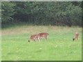
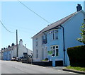
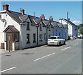
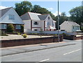
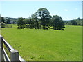
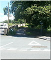

11 photos from this area
Area Information
Key information about the SA19 6UW including its size, population, and administrative classification.
- Area Type
- Postcode
- Area Size
- 13.2 hectares
- Population
- 1509
- Population Density
- 33 people/km²
House Prices in SA19 6UW
20
Properties
£333,402
Average Sold Price
£160,000
Lowest Price
£512,325
Highest Price
Showing 20 properties
| Address | Type | Beds | Baths | Last Sale Price | Last Sale Date | |
|---|---|---|---|---|---|---|
| Llwyncelyn, 0 Heol Cennen, Ffairfach, Llandeilo, SA19 6UW | Detached | 4 | 2 | £512,325 | Sep 2025 | |
| 101 Heol Cennen, Ffairfach, Llandeilo, SA19 6UW | Detached | 4 | 2 | £460,000 | Jul 2025 | |
| 97 Heol Cennen, Ffairfach, Llandeilo, SA19 6UW | house | - | - | £355,000 | Sep 2024 | |
| 111 Heol Cennen, Ffairfach, Llandeilo, SA19 6UW | Detached | 4 | 1 | £370,000 | Jun 2024 | |
| 99 Heol Cennen, Ffairfach, Llandeilo, SA19 6UW | house | 2 | 2 | £280,000 | May 2024 | |
| Gorwel Deg, Heol Cennen, Ffairfach, Llandeilo, SA19 6UW | Bungalow | - | - | £342,500 | Jan 2022 | |
| 109A Heol Cennen, Ffairfach, Llandeilo, SA19 6UW | Bungalow | 3 | 1 | £228,000 | Dec 2018 | |
| 109 Heol Cennen, Ffairfach, Llandeilo, SA19 6UW | Detached | 3 | 2 | £325,000 | Nov 2018 | |
| Brynawelon, 0 Heol Cennen, Ffairfach, Llandeilo, SA19 6UW | Detached | 3 | 2 | £333,000 | Dec 2016 | |
| 99A Heol Cennen, Ffairfach, Llandeilo, SA19 6UW | Bungalow | 4 | 3 | £210,000 | Nov 2016 |
Page 1 of 2
Energy Efficiency in SA19 6UW
Amenities
Schools
| Rank | School | Type | Entry gender | Ages |
|---|
Explore more schools in this area
Go to Schools tabDemographics
Household Size
Two person
most common
Accommodation Type
Houses
most common
Tenure
84
majority
Ethnic Group
White
most common
Religion
N/A
most common
Household Composition
N/A
most common
Age
47
median
Adults (30-64 years)
most common
Household Deprivation
N/A
with no deprivation
NS-SEC
41
in Lower managerial occupations
Explore more demographic insights in this area
Go to Demographics tabPlanning
Planning Constraints
- Flood RiskPremium
- Ramsar Wetland SitesPremium
- Area of Outstanding Natural BeautyPremium
- Protected Nature ReservePremium
- Protected WoodlandPremium
- Crime RiskPremium