Area Overview for Llanfair-ar-y-Bryn Community
Photos of Llanfair-ar-y-Bryn Community
Area Information
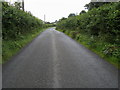
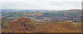
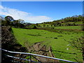
Living in Llanfair-ar-y-Bryn Community means residing within a vast civil parish covering 97.1 square kilometres. This expansive rural area offers a distinct experience compared to densely populated urban centres. The sheer size of the parish suggests a spacious environment where distance between settlements is a defining characteristic of daily life. You are purchasing into a locality defined by its open land rather than high-rise developments. The area functions as a traditional Welsh parish, providing a settled, long-term environment for its inhabitants. There is no indication of rapid change or speculative development in the immediate description of this space. Instead, the focus remains on the established nature of the community over its large geographical footprint. Prospective buyers must consider how this scale affects their access to local services and neighbours. The community relies on its infrastructure to connect residents across such a wide territory.
- Area Type
- Parish
- Area Size
- 97.1 km²
- Population
- Not available
- Population Density
- Not available
Demographics
The demographic profile of Llanfair-ar-y-Bryn Community reveals a population with a median age of 70 years. This statistic indicates that the majority of residents are older adults living in a retirement-focused environment. The household composition data is currently unverified, but the age profile strongly suggests low household formation rates typical of rural retirement zones. Homeownership stands at 72 per cent, which is a significant majority for this region. This figure demonstrates that most people living near Llanfair-ar-y-Bryn Community own their homes outright. The high ownership rate aligns with the older age demographic, as homeownership is often completed before retirement age. Diversity indicators and specific religious affiliations are not broken down in the available statistics for this parish. The community feels stable, anchored by long-term residents who have settled in this rural setting.
Household Size
Accommodation Type
Tenure
Ethnic Group
Religion
Household Composition
Age
Household Deprivation
NS-SEC
Explore more demographic insights in this area
Go to Demographics tabPlanning
Planning Constraints
- Flood RiskPremium
- Ramsar Wetland SitesPremium
- Area of Outstanding Natural BeautyPremium
- Protected Nature ReservePremium
- Protected WoodlandPremium
- Crime RiskPremium