Area Overview for Llangennech Community
Photos of Llangennech Community

Area Information
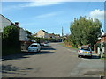
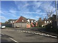
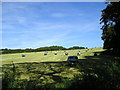
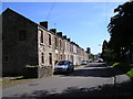
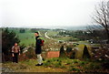
You will find Llangennech Community to be a low-lying village nestled in the Llanelli area of Carmarthenshire, covering 12.9 square kilometres. This civil parish sits approximately five kilometres north-east of Llanelli, positioned between the heavy industrial heritage of the region and the open countryside of the Morlais Valley. You can reach the village from Llanelli along the former main route B4297, which runs directly to the A48 at Pontardulais. The location offers a clear distinction from the dense coal mining towns that defined this area during its industrial peak. Today, the landscape features greened spoil heaps and a picturesque rural hinterland, yet the village retains a linear character developed alongside the Swansea, Llanelli, and Shrewsbury railway line. You will find the village bounded by marshes to the east and rising ground to the west. The community maintains a strong local identity centred around rugby culture via Llangennech RFC and a tradition of active non-conformist chapels, including Baptist, Independent, and Methodist sites. Living in Llangennech means residing in a space that has successfully transitioned from an industrial workforce centre to a peaceful residential area without losing its historical roots or local character.
- Area Type
- Parish
- Area Size
- 12.9 km²
- Population
- Not available
- Population Density
- Not available
Demographics
The heart of Llangennech Community is dominated by older residents, with a median age of 70 years. This indicates a community where you will primarily meet seniors rather than young families or a youthful workforce. The household composition and ethnic group data are recorded as total, reflecting the limited specific breakdown available for these categories. A defining feature for anyone considering homes in Llangennech is the high level of stability in tenure; 76% of households are owner-occupiers. This figure signals a settled community where property stays in local hands rather than circulating through the rental market. You will find that accommodation types are listed as total, meaning specific breakdowns of detached, semi-detached, or terraced houses are not explicitly detailed in the current records. The religion and predominant ethnic group fields are similarly noted as total. While specific deprivation data is not included in the provided figures, the high home ownership rate suggests residents have established roots over a long period. The age profile means services and community life cater largely to the needs of the retired population.
Household Size
Accommodation Type
Tenure
Ethnic Group
Religion
Household Composition
Age
Household Deprivation
NS-SEC
Explore more demographic insights in this area
Go to Demographics tabPlanning
Planning Constraints
- Flood RiskPremium
- Ramsar Wetland SitesPremium
- Area of Outstanding Natural BeautyPremium
- Protected Nature ReservePremium
- Protected WoodlandPremium
- Crime RiskPremium