Area Overview for CF5 4XG
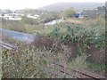
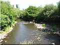
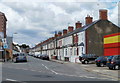
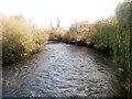
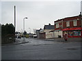
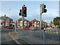
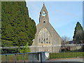
Photos of CF5 4XG
Area Information
CF5 4XG is a small residential cluster in Fairwater, a suburb of Cardiff, Wales. With a population of 1,606, it occupies a compact footprint bounded by areas like Llandaff, Canton, and Radyr. Fairwater, whose Welsh name *Y Tyllgoed* references ancient woods and streams, has been a Cardiff suburb since 1922. The area blends suburban tranquility with proximity to the city’s cultural and economic hubs. Residents benefit from nearby recreational spaces like The Dell, a public park featuring one of Britain’s earliest manmade ski slopes, and Fairwater Green, a hub for independent shops. The area’s history includes ties to Llandaff Cathedral and the Waterhall Estate, later transformed into schools and housing. Today, CF5 4XG is a mature community with a focus on homeownership, offering a mix of residential stability and access to local amenities. Its compact size means a tight-knit feel, with easy reach to rail, ferry, and retail options.
- Area Type
- Postcode
- Area Size
- Not available
- Population
- 1606
- Population Density
- 4352 people/km²
The property market in CF5 4XG is dominated by owner-occupied homes, with 80% of properties in private hands. The accommodation type is predominantly houses, reflecting the suburban nature of Fairwater. This makes the area more attractive to families seeking space and stability rather than rental-focused investors. The compact size of the postcode area means housing stock is limited, but the presence of established homes suggests a market with potential for long-term value. Buyers should consider the area’s proximity to schools like Cantonian High School and its integration with the Fairwater Community Campus, which may influence property desirability. While the small cluster limits immediate housing options, the emphasis on homeownership indicates a community that prioritises permanence, making it a viable choice for those seeking a settled lifestyle.
House Prices in CF5 4XG
No properties found in this postcode.
Energy Efficiency in CF5 4XG
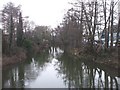
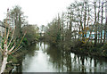
Living in CF5 4XG offers a blend of convenience and character. Nearby, Co-op Cardiff, Spar, and Farmfoods Ely provide essential retail and grocery needs, while the Fairwater Green offers independent shopping and community spaces. The Dell, a public park with a historic ski slope, is ideal for recreation, and the area’s proximity to the Waterhall Estate’s legacy adds a touch of local heritage. Waterbus stops like Cardiff Castle and Taffs Mead offer easy access to Cardiff’s waterfront, blending leisure with practical transport. The Fairwater Community Campus, housing multiple schools, ensures educational facilities are within reach. This mix of retail, green spaces, and transport options creates a balanced lifestyle, supporting both daily errands and leisurely pursuits. The area’s compact nature means amenities are within practical reach, enhancing the quality of life for residents.
Amenities
Schools
| Rank | School | Type | Entry gender | Ages |
|---|
Explore more schools in this area
Go to Schools tabDemographics
The population of CF5 4XG has a median age of 47, with the majority of residents aged between 30 and 64. This suggests a community of established professionals and families, reflecting a mature demographic profile. Home ownership is high at 80%, indicating a strong presence of long-term residents. The area is predominantly composed of houses, aligning with the typical suburban layout of Fairwater. The predominant ethnic group is White, which is common in Welsh suburbs. The absence of specific data on deprivation means no direct insight into economic challenges, but the high home ownership rate and age profile suggest a relatively stable, middle-income community. This demographic structure supports a consistent demand for local services and amenities, reinforcing the area’s character as a settled, family-oriented suburb.
Household Size
Accommodation Type
Tenure
Ethnic Group
Religion
Household Composition
Age
Household Deprivation
NS-SEC
Explore more demographic insights in this area
Go to Demographics tabPlanning
Planning Constraints
- Flood RiskPremium
- Ramsar Wetland SitesPremium
- Area of Outstanding Natural BeautyPremium
- Protected Nature ReservePremium
- Protected WoodlandPremium
- Crime RiskPremium