Area Overview for CF5 2ER
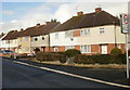
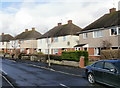
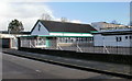
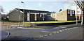
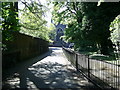
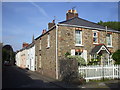
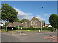
Photos of CF5 2ER
Area Information
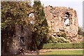
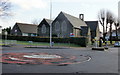
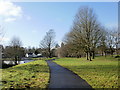
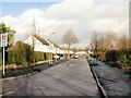
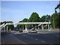
CF5 2ER lies within the historic district of Llandaff, a small residential cluster in north Cardiff, Wales. This area, spanning 3.0 hectares, is home to 1,508 residents, creating a densely populated yet compact community. Its name derives from the Welsh *Llandaf*, meaning “church on the River Taff,” reflecting its long-standing role as a religious and cultural hub. Incorporated into Cardiff in 1922, Llandaff retains a village-like atmosphere, with tree-lined streets and a mix of historic and modern architecture. The area is served by key transport links, including rail and ferry services, and is within reach of major amenities. With a population density of 51,052 people per square kilometre, it balances urban proximity with a quieter, residential character. Residents benefit from proximity to Llandaff Cathedral, a 12th-century structure, and historic sites like Insole Court. The area’s compact size means daily life is centred on local shops, schools, and green spaces, offering a blend of convenience and heritage.
- Area Type
- Postcode
- Area Size
- 3.0 hectares
- Population
- 1508
- Population Density
- 3199 people/km²
The property market in CF5 2ER is characterised by high home ownership, with 81% of residents living in owner-occupied homes. This indicates a stable, long-term population with limited rental activity. The accommodation type is predominantly houses, which is typical of a suburban or semi-rural setting. Given the area’s small size (3.0 hectares) and high population density, the housing stock is likely limited, with properties concentrated in a compact cluster. For buyers, this means competition for available homes, particularly in a market where rental options are scarce. The presence of historic and listed buildings, such as Insole Court and Rookwood House, may also influence property values and desirability. Buyers should consider the area’s proximity to Cardiff’s urban core, which offers access to broader services while retaining a quieter residential feel.
House Prices in CF5 2ER
Showing 13 properties
| Address | Type | Beds | Baths | Last Sale Price | Last Sale Date | |
|---|---|---|---|---|---|---|
| 6 Bruton Place, Llandaff, Cardiff, CF5 2ER | house | - | - | £375,000 | Mar 2021 | |
| 10 Bruton Place, Llandaff, Cardiff, CF5 2ER | house | - | - | £350,000 | Jul 2020 | |
| 14 Bruton Place, Llandaff, Cardiff, CF5 2ER | house | - | - | £650,000 | Aug 2018 | |
| Many Trees, 15 Bruton Place, Llandaff, Cardiff, CF5 2ER | Detached | 2 | 3 | £425,000 | Nov 2010 | |
| 13 Bruton Place, Llandaff, Cardiff, CF5 2ER | house | - | - | £265,000 | Oct 2009 | |
| 11 Bruton Place, Llandaff, Cardiff, CF5 2ER | Semi-detached | - | - | £336,000 | Feb 2008 | |
| 8 Bruton Place, Llandaff, Cardiff, CF5 2ER | Semi-detached | - | - | £299,950 | Sep 2007 | |
| Llwyn On, 5 Bruton Place, Llandaff, Cardiff, CF5 2ER | Semi-detached | - | - | £270,000 | May 2007 | |
| Dol Y Coed, 4 Bruton Place, Llandaff, Cardiff, CF5 2ER | Detached | 5 | 3 | £305,000 | Feb 2007 | |
| 12 Bruton Place, Llandaff, Cardiff, CF5 2ER | house | - | - | £257,500 | Jun 2004 |
Energy Efficiency in CF5 2ER
Daily life in CF5 2ER is enriched by nearby amenities, including five retail outlets such as Spar, Lidl Whitchurch, and another Spar, offering convenience for groceries and essentials. The area’s transport links provide access to multiple rail stations, ferry stops, and the Cardiff Bus Interchange, ensuring easy travel to Cardiff’s urban core. While parks and open spaces are not explicitly listed, the area’s historical character and proximity to Llandaff Cathedral suggest green spaces are part of its heritage. Residents can enjoy leisure activities at the cathedral, historic sites like Insole Court, and the BBC Wales Broadcasting House. The compact layout means amenities are within practical reach, supporting a self-contained lifestyle. The blend of retail, transport, and cultural landmarks contributes to a balanced, accessible environment for residents.
Amenities
Schools
Near CF5 2ER are two schools: Llandaff City C.I.W. Primary School and The Bishop Of Llandaff C.I.W. High School. Both are described as “other” in type, though specific Ofsted ratings are not provided in the data. The presence of a primary and high school within the area offers families a vertically integrated education system, reducing the need for long commutes. These institutions likely cater to the local population, which skews towards adults aged 30–64, suggesting a focus on family-oriented schooling. The schools’ names reflect the area’s historical ties to the Bishop of Llandaff, a legacy of its religious significance. For parents, the proximity of both schools to homes in CF5 2ER provides convenience and continuity in education, though further details on academic performance or facilities are not available.
| Rank | School | Type | Entry gender | Ages |
|---|
Explore more schools in this area
Go to Schools tabDemographics
The community in CF5 2ER is predominantly composed of adults aged 30–64, with a median age of 47. This suggests a mature, stable population, likely with established careers and families. Home ownership is high, at 81%, indicating a strong presence of long-term residents and a lower rental market. The accommodation type is primarily houses, reflecting a suburban rather than high-density residential profile. The predominant ethnic group is White, though specific diversity statistics are not provided. The population density of 51,052 people per square kilometre is exceptionally high for a small area, which may influence local infrastructure and community dynamics. This density, combined with a mature age profile, suggests a focus on quality of life, with amenities and services tailored to older and middle-aged residents.
Household Size
Accommodation Type
Tenure
Ethnic Group
Religion
Household Composition
Age
Household Deprivation
NS-SEC
Explore more demographic insights in this area
Go to Demographics tabPlanning
Planning Constraints
- Flood RiskPremium
- Ramsar Wetland SitesPremium
- Area of Outstanding Natural BeautyPremium
- Protected Nature ReservePremium
- Protected WoodlandPremium
- Crime RiskPremium