Area Overview for CF3 8YF
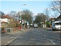
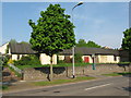
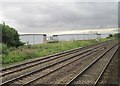
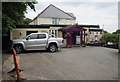
Photos of CF3 8YF


Area Information
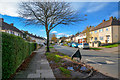
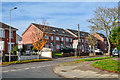
CF3 8YF, located in the east of Cardiff, Wales, is a small residential cluster with a population of 1,416. Historically part of Monmouthshire, it became a suburb of Cardiff in 1938 and remains a quiet, family-oriented area. The district lies east of the River Rhymney, with a mix of social and private housing. Its character is defined by a blend of historical sites, such as the Norman-era Caer Castell ruins and the 12th-century Church of St Augustine, alongside modern amenities. Daily life here is shaped by proximity to transport links, including Heath High Level and Cardiff Queen Street railway stations, and the Cardiff Bus Interchange. Residents benefit from a range of retail options, from local shops on Newport Road to larger stores like Sainsburys. The area’s compact size and integration into Cardiff offer a balance of suburban tranquility and urban accessibility.
- Area Type
- Postcode
- Area Size
- Not available
- Population
- 1416
- Population Density
- 4246 people/km²
CF3 8YF is a residential area where 47% of homes are owner-occupied, with houses forming the predominant accommodation type. This suggests a mix of private ownership and rental properties, though the exact proportion of the latter is not specified. The area’s small size and integration into Cardiff’s east side mean property availability is limited, with homes likely spread across the district’s historic and modern developments. The presence of social housing, alongside private residences, indicates a diverse housing market. Buyers should consider the area’s compact nature, which may limit options for larger properties or new builds. Proximity to transport links and local amenities enhances its appeal, though the lack of detailed property price data means market trends remain opaque.
House Prices in CF3 8YF
No properties found in this postcode.
Energy Efficiency in CF3 8YF
CF3 8YF offers a blend of practical amenities and historical charm. Local shops, beauty salons, and cafés line Newport Road and Rumney Hill, providing everyday conveniences. Retail options include Spar and Sainsburys Rumney, catering to household needs. The area’s proximity to Heath railway stations and the Cardiff Bus Interchange ensures easy access to Cardiff’s cultural and commercial hubs. For leisure, residents can explore the River Rhymney or visit the Church of St Augustine, a historic site with 12th-century origins. The nearby Rumney Pottery and remnants of the Norman Caer Castell add to the district’s character. This mix of retail, transport, and heritage creates a lifestyle that balances convenience with a touch of history, ideal for those seeking a settled, community-focused environment.
Amenities
Schools
| Rank | School | Type | Entry gender | Ages |
|---|
Explore more schools in this area
Go to Schools tabDemographics
The population of CF3 8YF is 1,416, with a median age of 47, indicating a community predominantly composed of adults aged 30–64. Home ownership stands at 47%, suggesting a mix of owner-occupied properties and rental housing. The area is characterised by houses as the primary accommodation type, reflecting a more traditional housing stock compared to flats. The predominant ethnic group is White, though specific data on diversity beyond this is not provided. The age profile and ownership figures suggest a stable, mature population, likely with established careers and families. The absence of deprivation data means the area’s socioeconomic profile remains unquantified, but the presence of local shops, industrial estates, and historical sites implies a functional, self-sufficient community.
Household Size
Accommodation Type
Tenure
Ethnic Group
Religion
Household Composition
Age
Household Deprivation
NS-SEC
Explore more demographic insights in this area
Go to Demographics tabPlanning
Planning Constraints
- Flood RiskPremium
- Ramsar Wetland SitesPremium
- Area of Outstanding Natural BeautyPremium
- Protected Nature ReservePremium
- Protected WoodlandPremium
- Crime RiskPremium