Area Overview for CF2 1DY
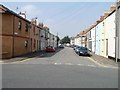
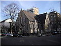
Photos of CF2 1DY


Area Information
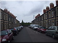
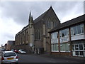
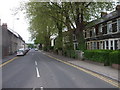
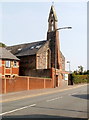
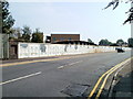
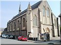
CF2 1DY, a small residential cluster in Cardiff, Wales, lies just outside the medieval east walls of the city. With a population of 1,998, it is an urban inner-city area with a history rooted in working-class communities, including railway and dock workers. The area has undergone regeneration since 2008, improving infrastructure such as parking, security, and public spaces like Cemetery Park. Adamsdown, the historical heart of the area, features Adamsdown Square and St Germans Church, alongside remnants of 19th-century developments like the former Cardiff Royal Infirmary. Living here offers proximity to Cardiff’s central amenities, with a mix of older housing stock and recent improvements. The area’s compact size means residents are within easy reach of rail, bus, and ferry services, making it a practical choice for those prioritising connectivity. Its blend of historical character and modern upgrades creates a distinct urban living experience, ideal for those seeking a balance between tradition and convenience.
- Area Type
- Postcode
- Area Size
- Not available
- Population
- 1998
- Population Density
- 11372 people/km²
The property market in CF2 1DY is characterised by a 34% home ownership rate, with houses being the predominant accommodation type. This suggests a mix of owner-occupied and rental properties, though the relatively low home ownership percentage indicates a stronger rental market in this small area. The presence of houses, rather than flats or apartments, implies a focus on family-friendly housing, which may appeal to buyers seeking larger living spaces. However, the area’s compact size means the housing stock is limited, and buyers should consider the immediate surroundings for more options. The regeneration efforts since 2008, including improved security and public amenities, may enhance property value over time. For those prioritising proximity to transport and urban services, CF2 1DY offers a practical, if modest, investment opportunity.
House Prices in CF2 1DY
No properties found in this postcode.
Energy Efficiency in CF2 1DY
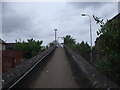
CF2 1DY offers a range of amenities within practical reach, including five retail outlets such as Tesco Clifton, Morrisons Daily, and Tesco Howard, ensuring daily shopping needs are met. The area’s transport links are extensive, with rail, bus, and ferry services providing access to Cardiff’s central hubs. Parks and recreational spaces like Cemetery Park, which includes a multi-use games area, add to the area’s appeal for families and active individuals. The historical character of Adamsdown, combined with modern improvements, creates a lifestyle that balances urban convenience with community amenities. The presence of nearby schools, though limited, and the area’s connectivity make it suitable for those prioritising practicality and accessibility in their daily lives.
Amenities
Schools
The only school explicitly listed near CF2 1DY is the Cardiff Steiner Early Years Centre, which operates as an early education provider rather than a primary or secondary school. This suggests the area may rely on nearby institutions for older children, though no other schools are detailed in the data. Families with young children might find the Steiner centre a suitable option, but those requiring primary or secondary education may need to look beyond CF2 1DY. The absence of further schools in the data means the educational landscape for older students remains unaddressed, potentially requiring additional research for comprehensive planning.
| Rank | School | Type | Entry gender | Ages |
|---|
Explore more schools in this area
Go to Schools tabDemographics
The median age in CF2 1DY is 47, with the most common age range being adults aged 30–64. Home ownership stands at 34%, indicating a higher proportion of rental properties in the area. The predominant accommodation type is houses, suggesting a mix of family homes and single-occupancy dwellings. The predominant ethnic group is White, reflecting the area’s historical ties to working-class communities. This demographic profile points to a mature, stable population with established roots in the area. The lower home ownership rate may imply a reliance on rental markets, which could influence housing availability for buyers. The absence of specific deprivation data means the quality of life remains unquantified, but the presence of amenities like retail, transport, and parks suggests a functional, if modest, standard of living.
Household Size
Accommodation Type
Tenure
Ethnic Group
Religion
Household Composition
Age
Household Deprivation
NS-SEC
Explore more demographic insights in this area
Go to Demographics tabPlanning
Planning Constraints
- Flood RiskPremium
- Ramsar Wetland SitesPremium
- Area of Outstanding Natural BeautyPremium
- Protected Nature ReservePremium
- Protected WoodlandPremium
- Crime RiskPremium