Area Overview for CF10 4TS
Photos of CF10 4TS


Area Information
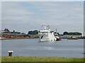
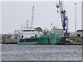
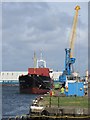
CF10 4TS occupies a specific residential cluster within the historic docklands of Butetown, a former civil parish that transformed from moorland into a key port suburb in the late 1800s. The postcode covers 1.6 hectares and supports a population of 1,049 people. This small area lies near coordinates 51.472729, -3.158973, positioned within the CF10 postcode area of Cardiff. Living in CF10 4TS means residing in a neighbourhood defined by its origins as working docks, shipping offices, and a multi-ethnic community that later regenerated into a modern waterfront district. The area sits near Cardiff Bay, where the development history includes significant landmarks like the Pierhead Building and the Coal Exchange. Today, this residential cluster offers proximity to major regeneration projects such as the Cardiff Bay Barrage and the Millennium Centre. Homes here benefit from the legacy of the 2nd Marquis of Bute, whose creation of West Bute Dock shaped the local landscape over 180 years ago. Residents live in a setting that balances historical maritime significance with contemporary convenience found just across the bay. You will find yourself within easy reach of the Welsh Assembly and Techniquest, yet the compact nature of the postcode ensures you remain close to the original industrial heart of the region.
- Area Type
- Postcode
- Area Size
- 1.6 hectares
- Population
- 1049
- Population Density
- 509 people/km²
The housing stock in CF10 4TS is distinctively characterised by flats, which form the primary accommodation type for this 1.6-hectare cluster. With a recorded home ownership rate of only 27%, the area functions more as a rental market than an owner-occupied estate. This low ownership figure suggests that many homes in CF10 4TS are let to tenants, often appealing to professionals working in nearby Cardiff Bay. The demographic profile, with a median age of 47 and most residents falling into the 30-64 year range, aligns with the typical profile of renters seeking flat-based living close to work. Buyers looking at this specific postcode should anticipate a landscape where leasehold flats dominate, rather than freehold family homes or detached houses. The small area size limits the variety of property types to what fits within this dense residential cluster near the waterfront. If you are considering purchasing homes in CF10 4TS, you must navigate a market where rental demand drives prices more than buyer ownership trends. The area offers immediate access to the modernised district that replaced the former docks, though the ownership statistics indicate limited opportunity for new freehold accumulation within these specific boundaries.
House Prices in CF10 4TS
No properties found in this postcode.
Energy Efficiency in CF10 4TS
Residents of CF10 4TS enjoy practical access to major retail and leisure venues within the regenerated Cardiff Bay district. Five retail outlets are available nearby, including Co-op Cardiff, Sainsburys Cardiff Bay, and Tesco Cardiff. For leisure and water-based travel, five ferry options serve the area, with notable stops at Cardiff, Mermaid Quay Waterbus Stop, and Sovereign Quay Waterbus Stop. Transport links include five railway stations such as Cardiff Bay Railway Station, Cardiff Queen Street Railway Station, and Cardiff Central Railway Station, plus one bus interchange. Living in CF10 4TS places you steps away from the iconic Pierhead Building and the Welsh Assembly. You can visit the 1896-built St. Stephens Church or explore the Techniquest science centre opened in 1995. The Millennium Centre from 2004 and the Senedd debating chamber provide cultural amenities within practical reach. If you seek dining, Mermaid Quay and its shops are a short walk from your home in CF10 4TS. The area also features historic landmarks like the Coal Exchange from 1886 and the 1894 Avondale Hotel. Your daily life here blends historic maritime heritage with modern commercial convenience.
Amenities
Schools
| Rank | School | Type | Entry gender | Ages |
|---|
Explore more schools in this area
Go to Schools tabDemographics
The community in CF10 4TS displays a distinct age profile, with a median age of 47 years. Adults between 30 and 64 years represent the most common age range in this residential cluster. This demographic skew suggests a neighbourhood populated by established residents rather than young families or students. You can expect a mature population living in flats, which constitute the predominant accommodation type for this postcode. Exactly 27% of households in CF10 4TS own their homes, indicating a majority of residents likely navigate the rental market or seasonal tenancies. The area is predominantly White, reflecting the historical demographic shifts that occurred after the 1960s redevelopment resisted by Black communities and the subsequent regeneration efforts. The population density stands at 509 people per square kilometre across the 1.6 hectares covered by this specific cluster. Living in CF10 4TS means joining a stable, middle-aged community where long-term residents have witnessed the area's evolution from the seamen's strikes of 1911 to the modern cultural hub it is today.
Household Size
Accommodation Type
Tenure
Ethnic Group
Religion
Household Composition
Age
Household Deprivation
NS-SEC
Explore more demographic insights in this area
Go to Demographics tabPlanning
Planning Constraints
- Flood RiskPremium
- Ramsar Wetland SitesPremium
- Area of Outstanding Natural BeautyPremium
- Protected Nature ReservePremium
- Protected WoodlandPremium
- Crime RiskPremium