Area Overview for CF10 4TE
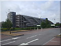
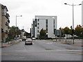
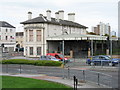
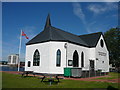
Photos of CF10 4TE


Area Information
CF10 4TE, part of Butetown in Cardiff Bay, Wales, is a compact residential area with a population of 1,049 people spread across 509 people per square kilometre. Once a 19th-century dockland shaped by the 2nd Marquis of Bute’s vision, it has evolved into a modern waterfront district. The area’s history is etched into its architecture, from the 1886 Coal Exchange to the 1990s regeneration that included the Cardiff Bay Barrage and the Senedd. Today, it blends historic landmarks with contemporary amenities. Residents benefit from proximity to Cardiff’s central rail network, ferry services, and retail hubs like Sainsburys and Tesco. The community, predominantly adults aged 30–64, reflects the area’s working-class roots and its transformation into a hub for finance, culture, and Black entrepreneurship. Living here means navigating a tight-knit, historically rich environment with easy access to both heritage and modern infrastructure.
- Area Type
- Postcode
- Area Size
- Not available
- Population
- 1049
- Population Density
- 509 people/km²
The property market in CF10 4TE is characterised by a low home ownership rate of 27%, suggesting most residents rent rather than own their homes. Flats dominate the housing stock, a legacy of the area’s 19th-century dockland planning. This makes the market more rental-oriented, with limited availability of owner-occupied properties. Buyers seeking flats in this small postcode area may find competition for a limited stock, particularly given the area’s compact size. The concentration of flats also implies a focus on urban living, with proximity to transport links and amenities. For those prioritising ownership, nearby areas with more detached or semi-detached homes might be more viable options.
House Prices in CF10 4TE
No properties found in this postcode.
Energy Efficiency in CF10 4TE
Living in CF10 4TE offers access to a mix of retail, transport, and cultural amenities. Nearby shops include Co-op Cardiff, Sainsburys Cardiff Bay, and Tesco Cardiff, providing daily necessities. The area’s ferry services at Mermaid Quay and Sovereign Quay offer scenic water routes to Cardiff’s waterfront, while rail stations like Cardiff Bay and Cardiff Central link to the wider region. The nearby Cardiff Bus Interchange adds flexibility for travel. The area’s historical character blends with modern convenience, from its 19th-century architecture to contemporary dining and leisure spots. This mix creates a dynamic lifestyle where residents can enjoy both heritage and urban amenities within easy reach.
Amenities
Schools
| Rank | School | Type | Entry gender | Ages |
|---|
Explore more schools in this area
Go to Schools tabDemographics
The population of CF10 4TE is 1,049, with a median age of 47. The majority of residents are adults aged 30–64, reflecting a mature demographic. Home ownership is relatively low at 27%, indicating a rental-heavy market. Flats are the predominant accommodation type, likely due to the area’s historical development as a dense residential cluster. The dominant ethnic group is White, though the area’s past as a multi-ethnic port suburb suggests historical diversity. The absence of specific deprivation data means quality of life indicators are not quantified here, but the age profile and housing stock suggest a community focused on stability and proximity to urban amenities.
Household Size
Accommodation Type
Tenure
Ethnic Group
Religion
Household Composition
Age
Household Deprivation
NS-SEC
Explore more demographic insights in this area
Go to Demographics tabPlanning
Planning Constraints
- Flood RiskPremium
- Ramsar Wetland SitesPremium
- Area of Outstanding Natural BeautyPremium
- Protected Nature ReservePremium
- Protected WoodlandPremium
- Crime RiskPremium