Area Overview for CF1 7UU
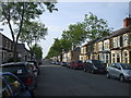
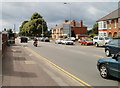
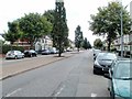
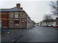
Photos of CF1 7UU


Area Information
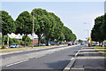
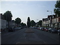
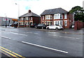
CF1 7UU is a small residential postcode area in Cardiff, Wales, characterised by its compact size and high population density of 1171 people per square kilometre. With a total population of 1591, it reflects a tightly knit urban community. Historically, the area was once marshy farmland linked to Margam Abbey, later developing into a housing suburb after the 1850s. Today, it lies between the River Taff and River Ely, with Penarth Road serving as a key historical and transport link. Living here means being part of a mature, established neighbourhood with a strong sense of local identity. The area’s proximity to Cardiff’s city centre, combined with its residential focus, offers a balance of urban convenience and quiet domesticity. Daily life is shaped by its connectivity to rail, retail, and water transport, while its historical roots add a layer of cultural depth. For those seeking a compact, well-served suburb with a distinct character, CF1 7UU presents a blend of practicality and heritage.
- Area Type
- Postcode
- Area Size
- Not available
- Population
- 1591
- Population Density
- 1171 people/km²
The property market in CF1 7UU is dominated by owner-occupied homes, with 65% of residents living in properties they own. This contrasts with rental markets typically found in more transient areas, suggesting a community of long-term residents. The accommodation type is predominantly houses, which is unusual for urban postcodes and may reflect the area’s historical development as a suburban extension of Cardiff. Given the small size of the postcode area, the housing stock is likely limited, meaning buyers may need to consider nearby neighbourhoods for more options. The focus on single-family homes indicates a preference for private, spacious living, which could appeal to those seeking stability and a sense of permanence. However, the compact nature of the area may also mean competition for properties, particularly for those prioritising proximity to city amenities.
House Prices in CF1 7UU
No properties found in this postcode.
Energy Efficiency in CF1 7UU
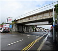
The lifestyle in CF1 7UU is shaped by its proximity to a range of amenities, including retail hubs like Tesco Grangetown and Lidl Cardiff, which cater to daily needs. The area’s rail network, with stations such as Ninian Park and Grangetown, facilitates easy travel to Cardiff’s city centre and beyond. Waterbus stops provide access to Cardiff’s waterways, adding a layer of leisure and connectivity. While the area is small, the combination of shops, transport, and historical sites like The Grange, an 800-year-old building, offers a blend of practicality and heritage. The presence of schools and the compact layout of the suburb create a community-oriented environment, where residents can access essential services without long commutes. This mix of convenience and local character defines the daily rhythm of life in CF1 7UU.
Amenities
Schools
The schools nearest to CF1 7UU include Ninian Park Primary School and Ysgol Newydd - Ninian Park Primary School, both categorised as 'other' in type. While specific Ofsted ratings are not provided, the presence of two primary schools suggests a focus on early education and family-oriented infrastructure. The mix of school types, though limited, may indicate a community prioritising foundational education. For families, the availability of two primary schools within reach offers convenience, though the absence of secondary schools or specialist institutions would require commuting to nearby areas. The schools’ names and proximity to the area reflect a historical and local connection to the Ninian Park district, reinforcing the area’s identity as a residential suburb with established educational services.
| Rank | School | Type | Entry gender | Ages |
|---|
Explore more schools in this area
Go to Schools tabDemographics
The population of CF1 7UU has a median age of 47, with the majority of residents falling within the 30-64 age range. This suggests a community of middle-aged adults, likely established professionals or long-term residents. Home ownership is high, with 65% of households owning their homes, indicating a stable, settled population. The area is predominantly composed of houses rather than flats, aligning with its residential character. The predominant ethnic group is White, reflecting the broader demographic trends in Cardiff. While no specific data on deprivation is provided, the high home ownership rate and mature age profile suggest a relatively stable quality of life. The absence of younger families or students may influence local amenities and services, but the area’s focus on housing for adults underscores its role as a long-term residential hub.
Household Size
Accommodation Type
Tenure
Ethnic Group
Religion
Household Composition
Age
Household Deprivation
NS-SEC
Explore more demographic insights in this area
Go to Demographics tabPlanning
Planning Constraints
- Flood RiskPremium
- Ramsar Wetland SitesPremium
- Area of Outstanding Natural BeautyPremium
- Protected Nature ReservePremium
- Protected WoodlandPremium
- Crime RiskPremium