Area Overview for Tongwynlais Community
Photos of Tongwynlais Community


Area Information
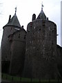
Tongwynlais Community is a small civil parish located in the north of Cardiff, covering an area of 4.3 km². The village sits at coordinates 51.532064, -3.251047 and benefits from a population of approximately 1,846 to 2,000 residents. Its character is quiet and friendly, making it particularly popular with cyclists as the Taff Trail passes directly through the locality. Historical depth defines the landscape, with records indicating an iron foundry was established there in 1564 by Sir Henry Sidney. A Norman motte-and-bailey castle was built on the site of Castell Coch after 1081 to defend Cardiff and control the River Taff route, later rebuilt in stone by Gilbert de Clare between 1267 and 1277. These ruins were acquired by the Earls of Bute in 1760 and rebuilt as a Gothic Revival castle from 1875 by the third Marquess of Bute. This Grade I listed landmark now overlooks the River Taff as the parish's most famous feature. Living in Tongwynlais Community means residing in a space where centuries of history intertwine with modern suburban life near the river. The area remains accessible yet retains a distinct village feel separate from the wider city. The community profile of Tongwynlais Community reveals a settled population with a median age of 70 years. This age profile suggests the area is a significant location for retirement living or families with older children. The most common age grouping reflects this demographic reality, centreing on the senior cohort. Home ownership stands at a high level of 70%, indicating that the majority of residents have equity in their homes rather than renting. This statistic suggests a stable community where families build long-term roots. Household composition and accommodation types are recorded in the total data provided for the parish. While specific breakdowns of ethnicity and religion are available in the total records for the area, the overarching statistical picture points towards a mature, owner-occupied neighbourhood. The high proportion of owner-occupied homes often correlates with lower residential turnover, contributing to a consistent local atmosphere. You can expect a community where neighbours likely know one another well due to the static nature of the residency. Data confirms the area is not dominated by transient rental housing. Homes in Tongwynlais Community are characterised by a strong rate of ownership, with 70% of properties occupied by their owners. This high percentage suggests a market where inheritance or long-term purchase is common rather than the transient rental sector seen in other parts of Cardiff. The 1.8 to 2,000 population contained within the 4.3 km² parish implies a density typical of a village rather than a dense urban neighbourhood. The accommodation types reflect this steady demographic, likely featuring a mix of detached and semi-detached houses suited to larger families or retirees. Buyers looking at Tongwynlais Community should expect a property market driven by owner-occupiers seeking stability. The historical presence of Castell Coch adds heritage value to the local real estate. Since 70% of residents own their homes, you will find few tenancies in the immediate vicinity. This environment can be advantageous for those seeking a quiet, established address away from the pressure of city life. The small footprint of the parish means limited space for massive new developments to displace existing housing. Digital connectivity forms a backbone of daily life for residents of Tongwynlais Community. The fixed broadband quality score reaches 88 out of 100, classifying the area as having excellent internet speeds for working from home or streaming. You can expect reliable high-speed connections suitable for heavy data usage. Mobile network coverage also performs well, with a score of 85 out of 100. This ensures that maintaining contact or using navigation apps remains seamless while walking the Taff Trail or driving within the parish. Such scores indicate that the infrastructure supports modern lifestyles without interruption. Living in Tongwynlais Community means you do not need to compromise on connectivity despite the village setting. The combination of strong fixed and mobile networks makes the area viable for remote workers who require dependability. Whether you are uploading work files or checking in with family, the digital transport infrastructure meets high standards. The village remains connected to the wider world through these robust telecommunication links. Environmental and safety assessments for Tongwynlais Community show mixed results regarding planning constraints and natural risks. Flood risk presents a low threat, with a score of 3.2 indicating low flood risk coverage. There are no Ramsar wetland sites or Areas of Outstanding Natural Beauty imposing strict planning constraints within the parish. However, two specific warning levels require your attention. The area contains protected nature reserves, scoring 13.31 out of 100, which means development in these specific zones is heavily restricted. Protected woodland also features significantly, with a score of 38.66. These scores indicate that a substantial portion of the 4.3 km² landholdings are conserved green spaces. While crime risk data is unavailable as it is currently only available for areas in England, the physical safeguarding of the environment is active. You can choose a home near the historic ruins with confidence that the green belts are legally protected. The low flood risk score provides peace of mind regarding water safety. The presence of warnings does not negate the overall safety but rather highlights the preservation of English nature. Is Tongwynlais Community suitable for retirees?The area is ideal for retirement living given the median age of 70 and a high home ownership rate of 70%. The village setting offers a quiet atmosphere with a population of approximately 1,846 to 2,000. Excellent broadband scores of 88 support remote living preferences common among seniors. How are the transport and internet connections in Tongwynlais Community?Digital infrastructure is strong with a fixed broadband score of 88 and mobile coverage of 85 out of 100. The Taff Trail runs through the village, providing a key amenity for cyclists and walkers within the 4.3 km² area. These connections ensure reliable access for working and communication while living in this north Cardiff parish. Are there any environmental risks when buying in Tongwynlais Community?Flood risk is low with a safety score of 3.2. However, buyers should note warnings regarding protected nature reserves and woodland. Scores of 13.31 and 38.66 respectively indicate restrictions on building developments in these specific conservation areas to preserve the local landscape. What is the home ownership situation in Tongwynlais Community?A significant 70% of households in this civil parish own their homes. This reflects a stable community where residents are likely to stay for long periods rather than renting. The high ownership rate suggests a market focused on owner-occupiers rather than the rental sector.
- Area Type
- Parish
- Area Size
- 4.3 km²
- Population
- Not available
- Population Density
- Not available
Demographics
The community profile of Tongwynlais Community reveals a settled population with a median age of 70 years. This age profile suggests the area is a significant location for retirement living or families with older children. The most common age grouping reflects this demographic reality, centreing on the senior cohort. Home ownership stands at a high level of 70%, indicating that the majority of residents have equity in their homes rather than renting. This statistic suggests a stable community where families build long-term roots. Household composition and accommodation types are recorded in the total data provided for the parish. While specific breakdowns of ethnicity and religion are available in the total records for the area, the overarching statistical picture points towards a mature, owner-occupied neighbourhood. The high proportion of owner-occupied homes often correlates with lower residential turnover, contributing to a consistent local atmosphere. You can expect a community where neighbours likely know one another well due to the static nature of the residency. Data confirms the area is not dominated by transient rental housing. Homes in Tongwynlais Community are characterised by a strong rate of ownership, with 70% of properties occupied by their owners. This high percentage suggests a market where inheritance or long-term purchase is common rather than the transient rental sector seen in other parts of Cardiff. The 1.8 to 2,000 population contained within the 4.3 km² parish implies a density typical of a village rather than a dense urban neighbourhood. The accommodation types reflect this steady demographic, likely featuring a mix of detached and semi-detached houses suited to larger families or retirees. Buyers looking at Tongwynlais Community should expect a property market driven by owner-occupiers seeking stability. The historical presence of Castell Coch adds heritage value to the local real estate. Since 70% of residents own their homes, you will find few tenancies in the immediate vicinity. This environment can be advantageous for those seeking a quiet, established address away from the pressure of city life. The small footprint of the parish means limited space for massive new developments to displace existing housing. Digital connectivity forms a backbone of daily life for residents of Tongwynlais Community. The fixed broadband quality score reaches 88 out of 100, classifying the area as having excellent internet speeds for working from home or streaming. You can expect reliable high-speed connections suitable for heavy data usage. Mobile network coverage also performs well, with a score of 85 out of 100. This ensures that maintaining contact or using navigation apps remains seamless while walking the Taff Trail or driving within the parish. Such scores indicate that the infrastructure supports modern lifestyles without interruption. Living in Tongwynlais Community means you do not need to compromise on connectivity despite the village setting. The combination of strong fixed and mobile networks makes the area viable for remote workers who require dependability. Whether you are uploading work files or checking in with family, the digital transport infrastructure meets high standards. The village remains connected to the wider world through these robust telecommunication links. Environmental and safety assessments for Tongwynlais Community show mixed results regarding planning constraints and natural risks. Flood risk presents a low threat, with a score of 3.2 indicating low flood risk coverage. There are no Ramsar wetland sites or Areas of Outstanding Natural Beauty imposing strict planning constraints within the parish. However, two specific warning levels require your attention. The area contains protected nature reserves, scoring 13.31 out of 100, which means development in these specific zones is heavily restricted. Protected woodland also features significantly, with a score of 38.66. These scores indicate that a substantial portion of the 4.3 km² landholdings are conserved green spaces. While crime risk data is unavailable as it is currently only available for areas in England, the physical safeguarding of the environment is active. You can choose a home near the historic ruins with confidence that the green belts are legally protected. The low flood risk score provides peace of mind regarding water safety. The presence of warnings does not negate the overall safety but rather highlights the preservation of English nature. Is Tongwynlais Community suitable for retirees?The area is ideal for retirement living given the median age of 70 and a high home ownership rate of 70%. The village setting offers a quiet atmosphere with a population of approximately 1,846 to 2,000. Excellent broadband scores of 88 support remote living preferences common among seniors. How are the transport and internet connections in Tongwynlais Community?Digital infrastructure is strong with a fixed broadband score of 88 and mobile coverage of 85 out of 100. The Taff Trail runs through the village, providing a key amenity for cyclists and walkers within the 4.3 km² area. These connections ensure reliable access for working and communication while living in this north Cardiff parish. Are there any environmental risks when buying in Tongwynlais Community?Flood risk is low with a safety score of 3.2. However, buyers should note warnings regarding protected nature reserves and woodland. Scores of 13.31 and 38.66 respectively indicate restrictions on building developments in these specific conservation areas to preserve the local landscape. What is the home ownership situation in Tongwynlais Community?A significant 70% of households in this civil parish own their homes. This reflects a stable community where residents are likely to stay for long periods rather than renting. The high ownership rate suggests a market focused on owner-occupiers rather than the rental sector.
Household Size
Accommodation Type
Tenure
Ethnic Group
Religion
Household Composition
Age
Household Deprivation
NS-SEC
Explore more demographic insights in this area
Go to Demographics tabPlanning
Planning Constraints
- Flood RiskPremium
- Ramsar Wetland SitesPremium
- Area of Outstanding Natural BeautyPremium
- Protected Nature ReservePremium
- Protected WoodlandPremium
- Crime RiskPremium