Area Overview for Ely Community
Photos of Ely Community

Area Information
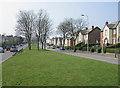
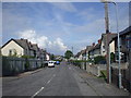
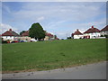
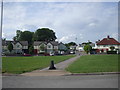
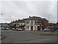
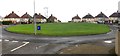
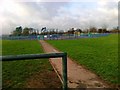
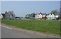
Living in Ely Community means residing within a civil parish that covers 3.0 km² in western Cardiff. The area holds a population of 3,222 people, creating a relatively dense environment with 1,064 people per square kilometre. This district evolved from a small hamlet named after the River Ely into a suburb by 1922. Modern boundaries place residents near Cowbridge Road West, south of the river and adjacent to Caerau. You will find that daily life is shaped by the neighbourhood's history, which includes post-war council housing developments built throughout the 1920s and 1930s. Although historically isolated, the area is now well positioned near the A4232 and the M4 motorway, often taking just 10 to 15 minutes by car to reach key connexion points. The community retains strong historical roots, evidenced by the Ely Railway Station which opened in 1850 and the nearby Ely Bridge reconstructed in 1911. Homes here are close to the River Ely and transport links that have served the area since Roman times. A distinct feature of the parish is the presence of the CAER Heritage Project, which has been rediscovers local archaeology since 2011. Residents live near sites such as the former Ely Racecourse and the Ely Brewery, remnants of the area's industrial and recreational past. The neighbourhood offers a mix of modern convenience and historical depth, allowing you to engage with the CAER Heritage initiative while enjoying access to major roads and the riverfront.
- Area Type
- Parish
- Area Size
- 3.0 km²
- Population
- 3222
- Population Density
- 1064 people/km²
Demographics
The demographic landscape of Ely Community reflects an older population, with a median age of 70 years. This indicates that the area is home to many retirees or older residents living in the established council housing estates. Household composition figures show a total household count but do not specify single-person, family, or multi-generational breakdowns in the available data. Similarly, while the area is characterised as a large, close-knit suburb, specific ethnic diversity statistics and religious affiliation figures are not provided in the source material. Regarding property tenure, 44% of residents own their homes, suggesting a significant proportion of the population remains within the rental sector or lives in privately rented accommodation. The remaining 56% of households therefore rely on tenancy or other tenure types not detailed here. Accommodation type data confirms the prevalence of the total housing stock found in the parish but lacks a permanent breakdown of flats versus houses. You can conclude that the area is dominated by an older demographic profile, likely corresponding to the 1,064 people per km² density of the 3.0 km² parish. The lack of specific data on age ranges beyond the median age of 70 means you cannot determine the exact number of young families or working-age adults currently residing in the community. The 44% home ownership rate suggests that while long-term residents have the opportunity for equity, many families continue to rent from local housing providers. Every claim regarding the community's composition stems directly from these recorded percentages and age metrics.
Household Size
Accommodation Type
Tenure
Ethnic Group
Religion
Household Composition
Age
Household Deprivation
NS-SEC
Explore more demographic insights in this area
Go to Demographics tabPlanning
Planning Constraints
- Flood RiskPremium
- Ramsar Wetland SitesPremium
- Area of Outstanding Natural BeautyPremium
- Protected Nature ReservePremium
- Protected WoodlandPremium
- Crime RiskPremium