Area Overview for Butetown Community
Photos of Butetown Community


Area Information
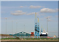
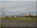
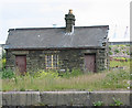
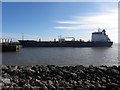
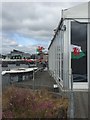
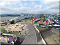
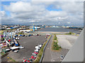
Butetown Community sits within Cardiff, Wales, covering an area of 7.8 km² with a population of 3,708. This unitary electoral division offers a distinct contrast between its industrial past and modern waterfront present. The neighbourhood transformed from barren moorland into a key port suburb in the late 1800s following the opening of West Bute Dock in 1839 by the 2nd Marquis of Bute. Originally defined by docks, shipping offices, and a multi-ethnic community of sailors and captains, the area has regenerated into a modern district linked to Cardiff Bay. Today, living in Butetown Community means residing near landmarks such as the Pierhead Building, which now houses the Welsh Assembly, and the Millennium Centre. The area is characterised by its historical significance, including the Coal Exchange built in 1886 and the former Welsh Industrial and Maritime Museum. While some original structures like the Mount Stuart Hotel were demolished during regeneration projects in the 1990s, new institutions like Techniquest and the Senedd debating chamber have anchored the social fabric. You will find yourself walking near iconic structures like the Big Windsor Hotel and the Avondale Hotel, which have stood since the mid-19th century. The postcode area is CF10, distinguishing it from other parts of Cardiff. Daily life here blends maritime heritage with contemporary amenities found at Mermaid Quay, creating a unique residential setting for those seeking proximity to both history and modern culture.
- Area Type
- Parish
- Area Size
- 7.8 km²
- Population
- 3708
- Population Density
- 477 people/km²
Demographics
The community profile reveals a mature population with a median age of 70 years. Residents living in Butetown Community generally fall into older age brackets, reflected by this high median figure. This demographic skew contrasts with typical city centre suburbs, suggesting a retirement presence or long-term families with elderly members. Housing data indicates a home ownership level of just 32%. This figure suggests a significant portion of the population rents their accommodation rather than owns their homes. With such a low ownership rate, the area likely leans towards social housing or private sector rentals. Household composition data is aggregated under the total category without specific breakdowns for singles, families, or multi-generational homes in the provided records. Similarly, detailed information regarding predominant ethnic groups and religious affiliations is not available in the specific dataset. Despite these gaps, the historical overview confirms the area originated as a multi-ethnic community of sailors and merchants. The 1960s redevelopment faced resistance from Black communities, a legacy that shapes the current social tapestry. You should note that the area has a population density of 477 people per km². This density is moderate for a dense urban block but feels more open due to the presence of the waterfront and large public buildings. The average resident can expect a quiet atmosphere given the age profile and the lack of smaller family-sized households dominating the census.
Household Size
Accommodation Type
Tenure
Ethnic Group
Religion
Household Composition
Age
Household Deprivation
NS-SEC
Explore more demographic insights in this area
Go to Demographics tabPlanning
Planning Constraints
- Flood RiskPremium
- Ramsar Wetland SitesPremium
- Area of Outstanding Natural BeautyPremium
- Protected Nature ReservePremium
- Protected WoodlandPremium
- Crime RiskPremium