Area Overview for NP22 5XD
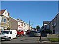
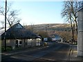
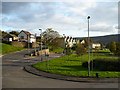
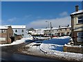
Photos of NP22 5XD
Area Information
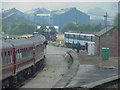
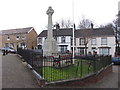
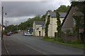
Living in NP22 5XD places you within a specific residential cluster nestled in the Upper Rhymney Valley. This postcode covers a population of 1,478 people living across a density of 1,221 people per square kilometre. You will be located in an area historically defined by the ironworks established in 1801 and the coal pits that followed, though the modern community sits alongside villages such as Pontlottyn and Rhymney itself. The location is geographically defined by coordinates 51.747513, -3.280429, situated in the historic county of Monmouthshire within the current Caerphilly county borough. Daily life here reflects a settlement that evolved from industrial roots into a quiet domestic environment. The area was originally created to serve the Sirhowy Iron Works and the Rhymney Iron Company, which utilised local coal and limestone. While the heavy industry shifted to collieries in the early 20th century, the physical landscape retains elements of this past. You will find yourself in a community where the parish church, a Grade II listed neo-classical building designed by Philip Hardwick, stands as a prominent feature. The Rhymney River flows nearby, providing access to scenic walking routes through the valley. Access today relies primarily on road networks, having moved on from the historic Rhymney Railway that once connected the town to Cardiff via a tunnel under Cefn Onn.
- Area Type
- Postcode
- Area Size
- Not available
- Population
- 1478
- Population Density
- 1221 people/km²
The property market in NP22 5XD is characterised primarily by residential houses rather than flats or high-density apartments. This focus on single-family homes reflects the area's history and planning constraints within the Upper Rhymney Valley. With 56 per cent of households owning their property, the area leans heavily towards owner-occupied living. This statistic indicates that a significant portion of the housing stock has remained in the same hands for extended periods, fostering a stable local environment. Buyers looking at homes in NP22 5XD will find a market defined by traditional architecture rather than modern urban developments. The predominance of houses means that the streetscapes you encounter will feature detached, semi-detached, or terraced family properties typical of 19th and early 20th-century industrial settlements. There is little evidence of the apartment blocks found in major city centres, as the low population of 1,478 does not support high-density vertical living. This housing model offers privacy and direct access to gardens, which are highly valued in this rural valley setting. For those considering buying or selling, understanding the 56 per cent ownership rate helps distinguish this area from rental hotspots in larger urban boroughs. The accumulation of owner-occupied homes often results in lower short-term turnover, meaning the local estate is generally stable and quiet.
House Prices in NP22 5XD
No properties found in this postcode.
Energy Efficiency in NP22 5XD
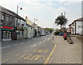
Daily life for residents of NP22 5XD revolves around practical amenities within practical reach. Retail options are visible in the form of Lidl Tredegar, Farmfoods Tredegar, and Spar, which provide essential shopping needs for the local population. These stores are located nearby, ensuring that groceries and household items are accessible without long journeys. Transport links include five notable rail stations in the vicinity, offering connections to wider transport networks for residents who require them. Nearby RAIL amenities act as a gateway for longer trips beyond the immediate valley. The lifestyle here is anchored by the convenience of these five retail outlets and five nearby rail access points. The Rhymney River and scenic Rhymney Valley walking routes offer free outdoor leisure, replacing the need for formal parks or indoor leisure centres. This natural environment serves as the primary recreational space, allowing residents to utilise the historical landscape for exercise and relaxation. Dining and socialising likely centre around the high street in Tredegar or the village green in Rhymney, supported by the presence of supermarkets and the historic parish church. The combination of local retail, historical sites, and natural access defines the rhythm of life for the 1,478 people who call this postcode home.
Amenities
Schools
Families living in NP22 5XD have access to Ysgol Y Lawnt, which is the nearest educational institution listed for the area. This school is located close enough to be a practical option for local children, although specific details regarding its Ofsted rating or specialism are not recorded in the current details. The presence of Ysgol Y Lawnt provides a key community resource for the surrounding residential cluster. Living in NP22 5XD means you are situated in a zone where children rely on this local facility for their education. The data highlights Ysgol Y Lawnt as the "other" type of school, suggesting it may serve a specific educational need or a particular age group within the wider Caerphilly county borough structure. While there is no detailed breakdown of secondary or primary divisions in the provided figures, the existence of this named institution confirms that educational support is integrated into the local neighbourhood fabric. For parents evaluating schools near NP22 5XD, Ysgol Y Lawnt is the primary reference point available. The proximity of this school ensures that daily commutes are short, fitting well with the lifestyle of residents whose median age is 47.
| Rank | School | Type | Entry gender | Ages |
|---|
Explore more schools in this area
Go to Schools tabDemographics
The community in NP22 5XD is dominated by adults between the ages of 30 and 64 years. This demographic reflects a median age of 47, indicating a mature population rather than a youthful family district. Home ownership stands at 56 per cent, suggesting that a clear majority of residents own their dwellings outright or through a mortgage rather than renting. The predominant accommodation type consists of houses, which aligns with the historical patterns of local development and the preference for detached or semi-detached family homes in this part of South Wales. Ethnically, the area is predominantly White, fitting the broader statistical profile of many former industrial valleys in this region. With 1,221 people living per square kilometre, the housing stock is relatively compact, ensuring that residents live in close proximity to their neighbours. The high level of home ownership often correlates with long-term community stability, as owners are typically more invested in the longevity and maintenance of their local neighbourhoods. This demographic profile supports a social environment geared towards stability and established family routines. The age distribution suggests an area where children may be present but adults form the core workforce and social backbone. The high ownership rate of 56 per cent is a significant factor when considering the estate market, as fewer homes are available for immediate rent compared to owner-occupied sectors.
Household Size
Accommodation Type
Tenure
Ethnic Group
Religion
Household Composition
Age
Household Deprivation
NS-SEC
Explore more demographic insights in this area
Go to Demographics tabPlanning
Planning Constraints
- Flood RiskPremium
- Ramsar Wetland SitesPremium
- Area of Outstanding Natural BeautyPremium
- Protected Nature ReservePremium
- Protected WoodlandPremium
- Crime RiskPremium