Area Overview for CF83 1UN
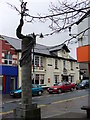
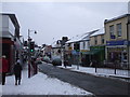
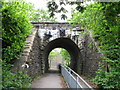
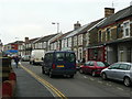
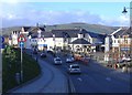
Photos of CF83 1UN


Area Information
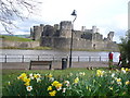
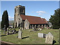
CF83 1UN is a small, tightly knit residential area in Caerphilly, Wales, with a population of 1,407. Nestled on the southern edge of the South Wales coalfield, it lies just 7 miles north of Cardiff, blending historical significance with modern convenience. The area’s character is shaped by its proximity to Caerphilly Castle, a 13th-century fortress that dominates the landscape. This postcode cluster is defined by its compact size and traditional housing stock, with a strong emphasis on owner-occupied homes. Daily life here is grounded in local amenities, including nearby railway stations and retail outlets. The community’s age profile, skewed toward adults aged 30–64, suggests a stable, established population. While the area lacks large-scale infrastructure, its strategic location offers easy access to Cardiff’s urban amenities without the city’s density. For those seeking a quiet, historically rich environment with practical connectivity, CF83 1UN provides a balance of heritage and modernity.
- Area Type
- Postcode
- Area Size
- Not available
- Population
- 1407
- Population Density
- 4102 people/km²
The property market in CF83 1UN is characterised by a high rate of home ownership (62%) and a focus on houses rather than flats or apartments. This suggests a market skewed toward owner-occupied properties, likely attracting families and long-term residents. The limited population and small area size mean the housing stock is relatively niche, with limited scope for new developments. Buyers should consider the area’s compact nature, which may result in a tight market with limited options. The predominance of houses indicates a preference for traditional, spacious living arrangements, which could appeal to those seeking a quieter, more established environment. However, the small scale of the area means property choices are constrained, requiring buyers to look closely at nearby postcodes for broader options.
House Prices in CF83 1UN
No properties found in this postcode.
Energy Efficiency in CF83 1UN
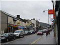
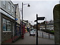
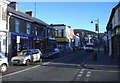
Life in CF83 1UN is shaped by its proximity to both historical landmarks and practical amenities. The nearby Caerphilly Castle, a 13th-century fortress, offers a tangible link to the area’s medieval past, while the remnants of a Roman fort add to its historical depth. For daily needs, residents have access to five retail outlets, including Iceland Caerphilly and Morrisons Pontypandy, ensuring grocery and household supplies are easily obtainable. The five nearby railway stations, such as Caerphilly and Energlyn & Churchill Park, provide efficient commuting options to Cardiff and surrounding areas. While the area’s small size limits large-scale leisure facilities, its blend of historical sites, local shops, and transport links creates a self-contained yet connected lifestyle. The presence of these amenities fosters a sense of convenience without the need for long journeys.
Amenities
Schools
| Rank | School | Type | Entry gender | Ages |
|---|
Explore more schools in this area
Go to Schools tabDemographics
The population of CF83 1UN is 1,407, with a median age of 47, indicating a mature demographic. The most common age range is adults aged 30–64, suggesting a community of long-term residents and families. Home ownership is high at 62%, with houses being the predominant accommodation type. The majority of residents identify as White, reflecting the area’s demographic composition. This profile points to a settled, stable population with strong ties to the local area. The absence of specific deprivation data means quality of life is inferred from the area’s amenities and infrastructure. The low flood risk and lack of environmental constraints further support a secure living environment. For buyers, this suggests a community that prioritises stability and long-term residency over transient populations.
Household Size
Accommodation Type
Tenure
Ethnic Group
Religion
Household Composition
Age
Household Deprivation
NS-SEC
Explore more demographic insights in this area
Go to Demographics tabPlanning
Planning Constraints
- Flood RiskPremium
- Ramsar Wetland SitesPremium
- Area of Outstanding Natural BeautyPremium
- Protected Nature ReservePremium
- Protected WoodlandPremium
- Crime RiskPremium