Area Overview for CF8 7WY
Photos of CF8 7WY
Area Information
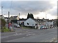
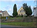
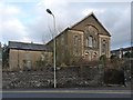
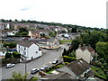
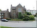
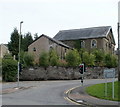
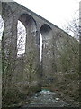
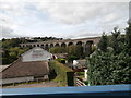
CF8 7WY sits within the historic civil parish of Gelligaer, a community in the County Borough of Caerphilly located in the Rhymney River valley. This specific postcode covers a small residential cluster characterised by its ancient nucleated settlement origins dating back to the Roman period. The area encompasses the village of Gelligaer alongside the nearby towns of Hengoed and Ystrad Mynach. Currently, the specific residential cluster recorded a population of 1,931 residents. The neighbourhood retains a rural look and feel distinct from the surrounding modern urban conurbations to the south and west. Residents live in a setting defined by historically significant landmarks, including ancient standing stones, village stocks, and the remains of a Roman fort excavated in the early 20th century. The core area is recognised as a conservation area with nationally important monuments showing long continuity of occupation. Living in this sector offers proximity to significant history alongside the benefits of a quieter environment compared to the larger towns. The site sits on a historic ridge-top road northward from Cardiff, providing a direct link to the wider region while maintaining its own distinct identity as a place with deep roots.
- Area Type
- Postcode
- Area Size
- Not available
- Population
- Not available
- Population Density
- Not available
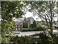
Homes in CF8 7WY are predominantly detached or semi-detached houses within a conservation area. The market dynamics are heavily skewed toward ownership, with 72% of residents owning their homes outright or with a mortgage. This high ownership rate defines the local market as primarily an owner-occupied area rather than a rental sector. Accommodation type data confirms that houses form the backbone of the housing stock, replacing any earlier industrial housing developments found in the surrounding towns of Hengoed or Ystrad Mynach. Buyers looking at this small postcode should expect a market where established properties dominate new builds. The cluster nature of the residential area means that housing diversity is likely limited compared to larger urban districts. Prospective buyers seeking houses in this specific sector are entering a market where stock availability may reflect the low population density of 1,931 residents. The focus remains on traditional dwelling types suited to the village character of Gelligaer.
House Prices in CF8 7WY
No properties found in this postcode.
Energy Efficiency in CF8 7WY
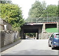
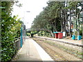
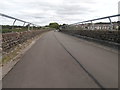
Daily life for residents of CF8 7WY benefits from a range of amenities within practical reach. Residents have access to five railway stations, including Hengoed Railway Station, Ystrad Mynach Railway Station, and Pengam Railway Station, which serve the wider Gelligaer community. This rail network provides direct links to Cardiff and other major towns across Wales. For retail needs, shoppers can visit Tesco Hengoed, Lidl Ystrad, and Spar, all located within easy commuting distance. These specific venues cover the essential shopping requirements for households in this postcode. The proximity to Hengoed and Ystrad Mynach expands the range of leisure and dining opportunities available outside the immediate village. Living in this sector means balancing the quiet of a conservation village with the convenience of established retail hubs and rail connections. The presence of these five rail services and three key retailers ensures that daily chores do not consume significant travel time.
Amenities
Schools
Residents looking for education options have Hengoed Primary School situated nearby. This institution serves as the primary educational provision for children within the immediate catchment. The data explicitly lists Hengoed Primary School as an available option for families living in the CF8 7WY postcode area. There are no secondary schools or other independent institutions detailed for this specific small residential cluster in the provided records. Families must consider the travel distance to this primary facility as the main option for early education. The reliance on a single listed primary school indicates that younger families are drawn to this area for proximity to this specific educational institution. Further research would be required for secondary education options, though they lie outside the scope of the specific data points for this neighbourhood.
| Rank | School | Type | Entry gender | Ages |
|---|
Explore more schools in this area
Go to Schools tabDemographics
The community profile for CF8 7WY reflects an established population with a median age of 47 years. Adults aged between 30 and 64 years represent the most common age range within this cluster. Over 72% of households are owner-occupied, indicating a strong tradition of settled residency. The dominant accommodation type consists of houses rather than flats, which aligns with the area's historic settlement patterns. The predominant ethnic group identifies as White. This demographic structure suggests a stable neighbourhood where long-term ownership is the norm. The higher proportion of older adults corresponds with the typical age profile of communities near major transport links where employment has historically been established. Home ownership rates of this magnitude often correlate with lower turnover of residents, creating a sense of continuity within the village. Families with older children or empty nesters will find this profile familiar, as the housing stock and age distribution cater to those who have already settled in the local area.
Household Size
Accommodation Type
Tenure
Ethnic Group
Religion
Household Composition
Age
Household Deprivation
NS-SEC
Explore more demographic insights in this area
Go to Demographics tabPlanning
Planning Constraints
- Flood RiskPremium
- Ramsar Wetland SitesPremium
- Area of Outstanding Natural BeautyPremium
- Protected Nature ReservePremium
- Protected WoodlandPremium
- Crime RiskPremium