Area Overview for Bridgend Community
Photos of Bridgend Community


Area Information
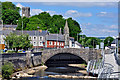
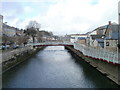
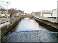
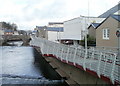
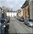
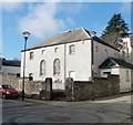
Living in Bridgend Community means residing within a civil parish that covers approximately 6.5 square kilometres in southern Glamorgan. This area, located within Bridgend County Borough, combines a long history with a modern residential function. Origins trace back to pre-Norman Welsh princes and the medieval settlement established along the River Ogmore. Robert Fitzhamon established lordships following the 1093 Norman conquest, and Maurice de Londres later gifted lands that formed Ewenny Priory. By the 15th century, the location served as a busy trading centre featuring annual fairs and a weekly market. Coal mining and ironworks developed in surrounding valleys from the 17th to the 19th centuries, transforming the local economic landscape. The community takes its current form from the 1974 creation of the parish, which underwent significant boundary changes in 1996 to incorporate much of the former Ewenny community, including Heronston. This administrative evolution placed the area firmly within the broader urban sprawl while maintaining distinct local identities. You will find the postcode CF31 1AB anchoring this countryside-market hybrid, situated at coordinates 51.50692227438389, -3.579413222373261. The population stands at 1,759 residents, creating a close-knit environment. Your daily life here balances proximity to industrial heritage sites with access to the wider amenities found in the Pen-y-bont ar Ogwr local authority. Understanding this historical depth provides necessary context for the current living experience.
- Area Type
- Parish
- Area Size
- 6.5 km²
- Population
- 1759
- Population Density
- 270 people/km²
Demographics
The people living in Bridgend Community reflect a notably older population structure compared to national averages. The median age is recorded at 70 years, indicating that the demographic consists primarily of older adults. While specific breakdowns by age bands are not detailed beyond the total count, the high median figure suggests you are entering a retirement-oriented neighbourhood. Home ownership is the dominant tenure type, with 64 per cent of households owning their residences outright or with a mortgage. This statistic contrasts sharply with areas dominated by private rental sectors, meaning you are buying into a stable stock rather than a transient one. The household composition data confirms that the area is organised around total household types, reflecting standard domestic units rather than large institutional blocks. In terms of accommodation types, the available data provides a total figure rather than a breakdown between detached, semi-detached, or terraced dwellings. However, the ownership rate implies a significant presence of freeholds or leaseholds suitable for long-term settling. There is no data provided regarding specific ethnic diversity or religious adherence within the community boundaries. You cannot make assumptions about diversity without explicit statistical backing for this specific parish. The existing figures suggest a traditional demographic profile focused on stability rather than rapid demographic shifts or high-density housing developments.
Household Size
Accommodation Type
Tenure
Ethnic Group
Religion
Household Composition
Age
Household Deprivation
NS-SEC
Explore more demographic insights in this area
Go to Demographics tabPlanning
Planning Constraints
- Flood RiskPremium
- Ramsar Wetland SitesPremium
- Area of Outstanding Natural BeautyPremium
- Protected Nature ReservePremium
- Protected WoodlandPremium
- Crime RiskPremium