Area Overview for Coity Higher Community
Photos of Coity Higher Community
Area Information
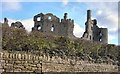
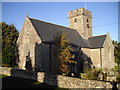
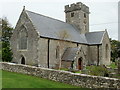
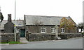
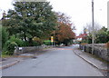
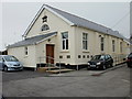
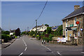
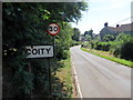
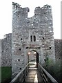
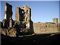
Coity Higher Community sits on 7.4 square kilometres of land within Bridgend County Borough, south Wales. This unitary electoral division encompasses the north western suburbs of Bridgend town, creating a distinct living environment that includes the villages of Coity and Litchard. The area is defined by its northern boundary along the M4 motorway, which separates it from communities to the north, while Brackla lies to the south. Historically, this was the seat of the Norman lord Payn de Turberville, who established Coity Castle in the early 12th century. The site later passed through several families, including the Turbervilles, Berkerolles, Gamages, and Sydneys, before the structure became ruinous by 1833. The population grew significantly during the late 20th century, rising from 835 in 2001 to 6,078 in 2011. You will find historic landmarks here, such as the Grade I listed Coity Castle and the 14th-century Church of St Mary. These sites, alongside Grade I listed Ty Mawr House and Pendre Hospital, anchor the community's identity. Daily life in Coity Higher blends modern suburban living with centuries of heritage. The area remains connected to the wider region through historical transport links, including the original Bridgend Railway from 1830 and subsequent integration with the Great Western Railway in 1923. Residents enjoy access to well-preserved architecture while benefiting from their location within the greater Bridgend area.
- Area Type
- Parish
- Area Size
- 7.4 km²
- Population
- 4475
- Population Density
- 605 people/km²
Demographics
The community profile reflects a mix of residents living in a diverse housing stock across 7.4 square kilometres. Approximately 51 per cent of households in Coity Higher Community own their homes outright. Another 26 per cent own with a mortgage, while 22 per cent rent their properties. This composition suggests a balanced market where owner-occupiation prevails but a substantial rental sector exists. The demographic shift from 835 residents in 2001 to 6,078 in 2011 indicates growth, though current age breakdowns are not detailed in available records. Households vary in size, with many considering the area suitable for families or professionals working in Bridgend town. The presence of significant historical estates, such as the former Lordship of Coity and now-listed Grade I sites, hints at varied property values and household incomes. Without specific deprivation indices, one cannot quantify income inequality, but the mix of ownership types points to socioeconomic depth. Families likely appreciate the proximity to the M4 motorway for commuting, while those valuing history find comfort near Coity Castle and the Church of St Mary. The 2011 census tallies remain the most recent concrete data point, illustrating a community that has expanded over the last decade. Prospective buyers should examine personal circumstances against the 51 per cent outright ownership rate to gauge potential investment stability.
Household Size
Accommodation Type
Tenure
Ethnic Group
Religion
Household Composition
Age
Household Deprivation
NS-SEC
Explore more demographic insights in this area
Go to Demographics tabPlanning
Planning Constraints
- Flood RiskPremium
- Ramsar Wetland SitesPremium
- Area of Outstanding Natural BeautyPremium
- Protected Nature ReservePremium
- Protected WoodlandPremium
- Crime RiskPremium