Area Overview for Gorebridge and Mayfield
Photos of Gorebridge and Mayfield


Area Information
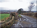
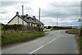
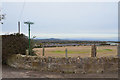
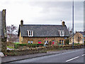
Gorebridge and Mayfield is a built-up area located in Scotland, covering a total size of 5.4 square kilometres. This locality functions as a distinct residential hub that balances suburban tranquility with essential practicalities. When you consider living in Gorebridge and Mayfield, you are choosing an area defined by its manageable scale and established community infrastructure. The region serves as a practical base for residents who require reliable access to transport links and local services without navigating the complexities of a major city centre. Daily life here revolves around proximity to key transport arteries, specifically the three nearby railway stations at Newtongrange, Gorebridge, and Eskbank. These stations form the backbone of your commute, offering direct connections to Edinburgh and beyond. The area is not a sprawling metropolis; rather, it is a concentrated community where neighbours and amenities are just minutes away. You will find that the district offers a straightforward living environment where the focus remains on convenience and connectivity. Whether you are commuting to the Capital or visiting local shops, the geography supports an efficient routine. The compact nature of this 5.4 kilometre stretch means you do not face long travel times for everyday tasks.
- Area Type
- Built Up Area 250
- Area Size
- 5.4 km²
- Population
- Not available
- Population Density
- Not available
Your daily lifestyle in Gorebridge and Mayfield is convenient and practical, supported by a cluster of essential amenities within easy reach. You do not need to travel far to satisfy basic retail needs, as five notable shopping locations are situated close by. These venues include the Co-op Dalkeith and two locations of Co-op Scotmid. These specific stores provide you with everyday necessities, ranging from groceries to budget-friendly goods, all easily accessible from your home. This concentration of retail outlets ensures that your weekly shop or quick errand requires minimal journey time. Beyond retail, your transport links are your primary leisure transport mechanism, utilising the five key railway stations mentioned previously. While specific parks or leisure centres are not detailed in the current dataset, the presence of Newtongrange Railway Station, Gorebridge Railway Station, and Eskbank Railway Station confirms that the area is well-integrated into the wider regional network. You can easily combine your commute with short trips to surrounding attractions or visit nearby towns using these railheads. The lifestyle here is defined by this efficiency. You trade the need for extensive local parks for the certainty of swift transportation and convenient shopping. This configuration suits those who value utility and who plan their leisure time around nearby cities or destinations rather than relying solely on local green spaces.
Amenities
Schools
| Rank | School | Type | Entry gender | Ages |
|---|
Explore more schools in this area
Go to Schools tabDemographics
Living in Gorebridge and Mayfield places you within a community characterized by specific demographic markers that define the local character. The population structure and household composition are shaped by the area's function as a residential zone accessible from Edinburgh. The most significant demographic factor affecting your quality of life is the level of deprivation, which stands at a score of 23.32 on a scale from 0 to 100. This specific figure indicates a relatively low level of deprivation when compared to the national average, suggesting that residents generally enjoy higher standards of living and better economic outcomes. You should understand what this low deprivation score implies for your future there. It correlates with higher average incomes, better educational attainment, and superior housing conditions within Gorebridge and Mayfield. The community benefits from a stable economic base, which means public services and local businesses often perform above regional standards. When you look at schools near Gorebridge and Mayfield, you are tapping into an environment that reflects these positive underlying statistics. The area attracts families seeking stability, and the low deprivation metric assures them of a supportive neighbourhood. Consequently, the daily experience for residents involves greater access to resources and fewer socioeconomic barriers, contributing to a settled and confident community atmosphere.
Household Size
Accommodation Type
Tenure
Ethnic Group
Religion
Household Composition
Age
Household Deprivation
NS-SEC
Explore more demographic insights in this area
Go to Demographics tabPlanning
Planning Constraints
- Crime RiskPremium