Area Overview for EH22 3BH
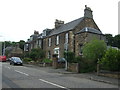
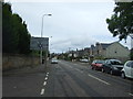
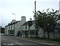
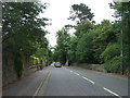
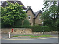
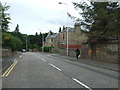
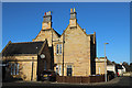
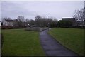
Photos of EH22 3BH
Area Information
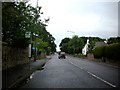
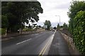
Living in EH22 3BH offers a quiet residential experience within a compact cluster of just 2.0 hectares. This postcode defines a specific pocket of Dalkeith, Scotland, where daily life revolves around proximity to essential services and convenient transport links rather than expansive landscapes. The area is entirely free from major planning constraints, lacking any Ramsar sites, areas of outstanding natural beauty, or protected woodlands within its boundaries. This absence of environmental restrictions often simplifies the planning process for future developments while maintaining a low flood risk profile for current homeowners. Residents appreciate that their immediate surroundings are not encroached upon by sensitive ecological sites. The suburb's character is defined by its manageable size, making it easy to navigate on foot or by bicycle to nearby train stations. Those seeking homes in EH22 3BH will find a location that balances tranquillity with accessibility. It is a place where the focus remains on practical living rather than scenic constraints or complex regulatory environments.
- Area Type
- Postcode
- Area Size
- 2.0 hectares
- Population
- Not available
- Population Density
- Not available
Detailed property market statistics for EH22 3BH, including home ownership percentages, average sale prices, or rental yields, are not available in the current data set. Consequently, a specific comparison between owner-occupied homes and rental properties cannot be made, nor can the prevailing accommodation types be quantified with precision for this exact postcode. Living in EH22 3BH means entering a small residential cluster of 2.0 hectares where the housing stock is likely suited to its compact nature. While specific figures are absent, the lack of planning constraints regarding protected woodlands or nature reserves may indicate flexibility in the types of development that have occurred or could occur here. Buyers viewing homes in this area should recognise that this rural part of Dalkeith offers a different dynamic to busy urban suburbs. The property market exists primarily to serve the local residential needs of a small community. Potential purchasers must rely on open market listings and local knowledge to gauge the types of properties most common in this specific pocket of Scotland.
House Prices in EH22 3BH
Showing 8 properties
| Address | Type | Beds | Baths | Last Sale Price | Last Sale Date | |
|---|---|---|---|---|---|---|
| 43 Eskbank Road, Dalkeith, EH22 3BH | Detached | 6 | 2 | - | - | |
| 45A Eskbank Road, Dalkeith, EH22 3BH | house | - | - | - | - | |
| 47A Eskbank Road, Dalkeith, EH22 3BH | Bungalow | - | - | - | - | |
| 43A Eskbank Road, Dalkeith, EH22 3BH | Detached | - | - | - | - | |
| Church Hall, St Davids Roman Catholic Church, 41 Eskbank Road, Dalkeith, EH22 3BH | commercial | - | - | - | - | |
| Rathan House, 45 Eskbank Road, Dalkeith, EH22 3BH | Detached | - | - | - | - | |
| 47 Eskbank Road, Dalkeith, EH22 3BH | Detached | - | - | - | - | |
| St Davids Roman Catholic Church, 41 Eskbank Road, Dalkeith, EH22 3BH | Unknown | - | - | - | - |
Energy Efficiency in EH22 3BH
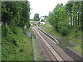
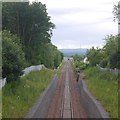
The lifestyle in EH22 3BH is defined by convenience and quick access to wider Dalkeith amenities. Although the postcode itself covers only a small residential footprint, its residents benefit from five notable retail options within practical reach. You can easily visit Morrisons Dalkeith, Farmfoods Dalkeith, or Lidl Dalkeith for your weekly groceries and household shopping needs. Transport connectivity is equally immediate, with five railway stations located nearby to facilitate commutes. Newtongrange Railway Station, Shawfair Railway Station, and Eskbank Railway Station provide efficient links to Edinburgh and beyond. This combination of retail and rail access creates a practical daily routine where you do not need a car for most errands. Families appreciate the ability to run errands at Lidl or Morrisons and catch a train at the nearby stations with ease. The area functions as a quiet residential hinterland that still enjoys the full amenities of the main town centre just a short distance away.
Amenities
Schools
| Rank | School | Type | Entry gender | Ages |
|---|
Explore more schools in this area
Go to Schools tabDemographics
Specific demographic data for EH22 3BH is not included in the available records, so a detailed analysis of the local age profile, household composition, or diversity metrics cannot be provided for this specific postcode. Without precise figures on household types or home ownership levels, it is impossible to construct an accurate picture of the community's structure. However, the absence of such data should not deter potential buyers; instead, it suggests that the area remains a genuine residential cluster without the heavy statistical footprint often found in larger town centres. The focus here is on the tangible realities of the location, such as the size of the residential land and the presence of key infrastructure. Prospective buyers looking to understand the social fabric of EH22 3BH will need to rely on broader neighbourhood trends or conduct individual research, as granular population statistics are not currently accessible for this small postcode footprint. The area operates as a distinct residential zone independent of wider demographic trends that might apply to Dalkeith as a whole.
Household Size
Accommodation Type
Tenure
Ethnic Group
Religion
Household Composition
Age
Household Deprivation
NS-SEC
Explore more demographic insights in this area
Go to Demographics tabPlanning
Planning Constraints
- Flood RiskPremium
- Ramsar Wetland SitesPremium
- Area of Outstanding Natural BeautyPremium
- Protected Nature ReservePremium
- Protected WoodlandPremium
- Crime RiskPremium