Area Overview for Inverclyde
Photos of Inverclyde
Area Information
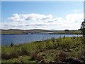
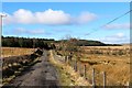
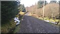
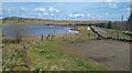
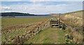
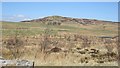
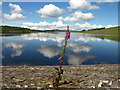
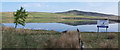
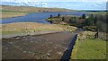
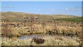
Living in Inverclyde offers a distinct experience within the Scottish unitary authority known for its local governance. The district covers an extensive landmass of 173.6 square kilometres, providing a wide expanse for residents to spread out or explore inland and coastal areas. This sizeable geography defines the daily rhythm of life, where distances between settlements can vary significantly compared to more compact urban zones. You navigate a landscape that balances rural tranquillity with the industrial heritage typical of the region. The area functions as a self-contained unit where community life often revolves around local hubs rather than a single centralised downtown. Daily life here depends heavily on your specific location within the borough. Some neighbourhoods offer proximity to the coast, while others sit closer to inland industrial zones. The sheer scale of 173.6 km² means that amenities might feel scattered to a new arrival unless you know the geography well. There are no designated Areas of Outstanding Natural Beauty within the boundaries, nor does the district contain protected nature reserves or woodlands at the highest level of designation. Instead, planning constraints include Ramsar wetland sites, indicating environmental sensitivity in certain low-lying sections. You move through an environment where safety regarding flooding remains low, with a consistent risk profile across most inhabited zones. This physical setup creates a practical reality for homebuyers prioritising space over dense urban convenience.
- Area Type
- District/Borough
- Area Size
- 173.6 km²
- Population
- Not available
- Population Density
- Not available
Demographics
The community in Inverclyde reflects the broader social patterns of its wider region, though specific age profiles, household type breakdowns, home ownership rates, accommodation statistics, and diversity figures are not included in the current information. Without access to precise demographic data, you cannot gauge whether families with young children dominate the population or if elderly residents form the largest group. Similarly, it is impossible to state the percentage of private renters versus owner-occupiers or to describe the mix of terraced houses and detached bungalows that characterises local streets. You also lack the particulars needed to understand the level of cultural or national diversity within the neighbourhoods. While official crime risk data is currently unavailable for Scottish areas, the lack of these specific statistical markers prevents a complete picture of the resident profile. This absence of detail means you must rely on local observation rather than census tables when assessing the demographic fabric of Inverclyde. Any attempt to quantify the age structure, tenure status, or background of the locals would require sources beyond the current dataset. Consequently, you cannot determine if the area feels more homogeneous or diverse without conducting independent field research or consulting local council publications directly. The focus shifts from interpreting hard numbers to observing the physical and visible interactions within the community spaces.
Household Size
Accommodation Type
Tenure
Ethnic Group
Religion
Household Composition
Age
Household Deprivation
NS-SEC
Explore more demographic insights in this area
Go to Demographics tabPlanning
Planning Constraints
- Flood RiskPremium
- Ramsar Wetland SitesPremium
- Area of Outstanding Natural BeautyPremium
- Protected Nature ReservePremium
- Protected WoodlandPremium
- Crime RiskPremium