Area Overview for G83 7YA
Photos of G83 7YA


Area Information
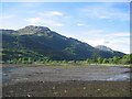
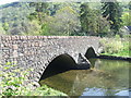
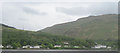
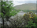
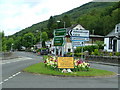
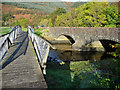
G83 7YA is a small residential postcode area in Scotland, characterised by its compact size and quiet, clustered housing. Situated in a rural setting, it offers a peaceful alternative to busier urban centres, with a focus on low-density living. The area is served by a single railway station, Arrochar & Tarbet Railway Station, which connects residents to nearby towns and beyond. Nearby, five ferry piers—Tarbet Pier, Inversnaid Pier, and Inveruglas Pier—provide access to local waterways, suggesting a strong connection to Scotland’s natural landscapes. While the broadband quality here is poor, with a score of 15, mobile coverage is fair at 74. This mix of connectivity options may appeal to those prioritising mobility over high-speed internet, though remote workers might find the limitations challenging. The area’s low flood risk and absence of protected natural sites indicate a relatively low environmental constraint, making it a viable option for those seeking a tranquil, low-maintenance lifestyle. G83 7YA is ideal for individuals or families looking for a secluded, nature-oriented environment with limited but functional transport links.
- Area Type
- Postcode
- Area Size
- Not available
- Population
- Not available
- Population Density
- Not available
House Prices in G83 7YA
No properties found in this postcode.
Energy Efficiency in G83 7YA
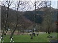
Living in G83 7YA offers a blend of rural tranquillity and accessible amenities. The nearby Arrochar & Tarbet Railway Station provides a direct link to regional services, while the five ferry piers—Tarbet, Inversnaid, and Inveruglas—open up opportunities for water-based travel and exploration. These piers may be particularly valuable for those interested in boating, fishing, or scenic cruises along local waterways. The area’s low environmental constraints, including no protected woodlands or Ramsar sites, suggest minimal restrictions on development or outdoor activities. However, the lack of detailed local shops, dining, or parks in the data means the lifestyle here is likely defined by the surrounding natural environment and the limited infrastructure of a small postcode area. Residents may need to travel further for retail or leisure options, making the area more suitable for those prioritising peace and proximity to nature over urban convenience.
Amenities
Schools
| Rank | School | Type | Entry gender | Ages |
|---|
Explore more schools in this area
Go to Schools tabDemographics
Household Size
Accommodation Type
Tenure
Ethnic Group
Religion
Household Composition
Age
Household Deprivation
NS-SEC
Explore more demographic insights in this area
Go to Demographics tabPlanning
Planning Constraints
- Flood RiskPremium
- Ramsar Wetland SitesPremium
- Area of Outstanding Natural BeautyPremium
- Protected Nature ReservePremium
- Protected WoodlandPremium
- Crime RiskPremium