Area Overview for Thurso
Photos of Thurso


Area Information
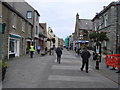
Thurso is a compact built-up area located in Scotland, covering an area size of 2.8 km². As a small town, it operates with the intimacy of a village while maintaining the essential infrastructure of a local community. Residents here navigate daily life within a tight geographical footprint, which means most of daily errands happen very close to home. The town supports a range of local services that cater to the needs of families and professionals alike. Living in Thurso offers a settled rhythm where the community is visibly defined by its proximity to amenities such as railway stations and ferry terminals. The town centre anchors the lifestyle for those living in homes in Thurso, providing easy access to retail outlets and transport links without the need for lengthy commutes. You can reach key destinations like the Scrabster Ferry Terminal and independent shops on foot or by short bus ride. The character of the town reflects its history as a coastal settlement, blending residential streets with public transport hubs. This layout supports a lifestyle where connectivity to the wider world remains possible despite the area's small scale. The town functions as a self-contained environment where services like Lidl Thurso and Co-op Thurso form the backbone of daily routine. Prospective buyers will find the limited land area contributes to a quiet, manageable environment rather than urban sprawl. Residents benefit from a location that prioritises practicality, with named entities like Georgemas Junction Railway Station offering rail connections to major cities. The town's identity hinges on these tangible links that integrate它与 the surrounding North Coast 500 route. Living here means relying on a supportive local network of businesses and transport nodes. The sheer compactness of the 2.8 km² footprint ensures that nothing is ever more than a journey away. This makes Thurso a distinct choice for those who value a close-knit setting over the anonymity of larger cities.
- Area Type
- Built Up Area 250
- Area Size
- 2.8 km²
- Population
- Not available
- Population Density
- Not available
Lifestyle in Thurso centres around the immediate availability of key amenities that serve the daily needs of the community. Residents have access to two railway stations, Thurso Railway Station and Georgemas Junction Railway Station, which anchor the town's connection to the rest of Scotland. These hubs allow you to travel to Inverness, Aberdeen, and beyond without leaving the immediate jurisdiction of the 2.8 km² built-up area. For those who prefer road or sea travel, Scrabster Ferry Terminal offers direct links to England, making it a unique gateway from the north coast of Scotland. The retail scene is equally accessible, with five notable shops within practical reach. Residents can stock up at Lidl Thurso, Co-op Thurso, and Morrisons Daily, ensuring that groceries and essential goods are never far away. These venues are not just businesses; they are social hubs where neighbours interact and community news spreads. On weekends, the town's compact layout means you can walk to most services, fostering a slower, more deliberate pace of life. The absence of large shopping malls is balanced by the concentration of local services in one area. This setup supports a lifestyle where you do not need a car for every single errand. The nearby amenities define the character of living in Thurso, offering a self-sufficient environment. You can combine a morning visit to Co-op Thurso with an evening commute from Georgemas Junction Railway Station, all within a short timeframe. This convenience is a major factor for families setting up homes in Thurso. The town's ability to cater to such varied needs from transport to shopping within a small footprint makes it an appealing choice for those seeking a grounded lifestyle. The proximity of Scrabster Ferry Terminal also adds a distinct coastal and historic flavour to the everyday experience of residents.
Amenities
Schools
| Rank | School | Type | Entry gender | Ages |
|---|
Explore more schools in this area
Go to Schools tabDemographics
The community in Thurso reflects the typical patterns of a scale town in Scotland. While the data does not provide specific details on age distribution or household sizes for this particular location, the broader context of such settlements suggests a mix of families and working-age adults. The town acts as a regional hub for the nearby rural communities, attracting residents who seek access to services while remaining close to nature. People living in Thurso often maintain ties to the wider North Coast region, commuting further away for specific opportunities or bringing rural families into the town centre for a better quality of life. Home ownership levels in similar Scottish towns tend to be significant, though exact figures for Thurso are not listed in the current assessment. Accommodation types typically range from traditional terraced housing to semi-detached family homes, fitting the 2.8 km² area efficiently. The population structure supports local schools and leisure facilities, indicating a stable presence of families. There is no indication of extreme diversity markers in the data, suggesting the town retains a strong local identity rooted in the surrounding Scottish landscape. Residents here likely value stability and long-term roots rather than transient living arrangements. The demographic profile aligns with other areas that prioritise home ownership and community cohesion. Families making the move to homes in Thurso can expect a neighbourhood where children attend local schools near Thurso and adults engage with established social networks.
Household Size
Accommodation Type
Tenure
Ethnic Group
Religion
Household Composition
Age
Household Deprivation
NS-SEC
Explore more demographic insights in this area
Go to Demographics tabPlanning
Planning Constraints
- Crime & SafetyPremium