Area Overview for AB25 2XR
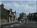
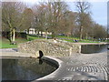
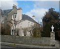
Photos of AB25 2XR

Area Information
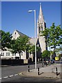
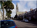
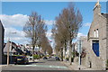
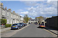
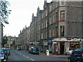
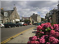
AB25 2XR represents a specific postcode covering a small residential cluster within the Aberdeen City council area. This location sits inside a historic royal burgh defined by granite architecture and its role as Europe's offshore oil capital. The residents here live on a total area of 1361 square metres, a footprint indicative of its compact residential nature. You are situated in a city that originated from two separate burghs, Old Aberdeen and New Aberdeen, along the Rivers Dee and Don. The neighbourhood benefits from a strategic coastal position that supports trade, education, and the energy sector. Living in AB25 2XR means being close to a major urban centre with deep historical roots. Human settlement in the broader Aberdeen area dates back 8000 years, yet the city's modern character was transformed significantly by the North Sea oil industry since 1969. This post-industrial era brought new opportunities while retaining a university-town atmosphere. The area provides access to notable landmarks such as St. Machar's Cathedral, established in 1424, and the world's largest granite building, Marischal College. You enjoy proximity to the region's largest seaport and the busy Aberdeen Heliport, which serve as key assets for the local economy. Daily life here is defined by the intersection of traditional Scottish history and modern industrial connectivity.
- Area Type
- Postcode
- Area Size
- 1361 m²
- Population
- Not available
- Population Density
- Not available
This postcode area functions as a small residential cluster within the larger Aberdeen housing stock. The property market here is influenced by the high home ownership percentage typical of established urban areas in north-east Scotland. You will find that homes in AB25 2XR are likely owner-occupied given the nature of the cluster and its integration into the existing city fabric. The housing stock reflects the region's granite architecture and 18th to 20th-century building styles that define the city's appearance. Buyers looking at this area access a compact market due to the 1361 square metre territory. The location near the River Dee and Don positions properties within a mix of residential zones developed as the city expanded. While specific price data is not supplied, the demand stems from the proximity to key emplyers and the university. The area avoids planning constraints like Areas of Outstanding Natural Beauty, meaning development possibilities remain tied to general urban growth patterns. You are purchasing a home in a district where the economy is driven by the offshore oil and gas industry. This creates a market where stability often follows the performance of the energy sector. The accommodation types available range from traditional stone buildings to modern developments supporting the workforce in the nearby ports and heliports.
House Prices in AB25 2XR
Showing 25 properties
| Address | Type | Beds | Baths | Last Sale Price | Last Sale Date | |
|---|---|---|---|---|---|---|
| D M Design Bedrooms Ltd, 218-220 Rosemount Place, Aberdeen, AB25 2XR | retail_financial | - | - | - | - | |
| 214F Rosemount Place, Aberdeen, AB25 2XR | Flat | - | - | - | - | |
| 214E Rosemount Place, Aberdeen, AB25 2XR | Flat | - | - | - | - | |
| 212H Rosemount Place, Aberdeen, AB25 2XR | Flat | - | - | - | - | |
| 216A Rosemount Place, Aberdeen, AB25 2XR | Flat | 1 | - | - | - | |
| 212A Rosemount Place, Aberdeen, AB25 2XR | Flat | 1 | - | - | - | |
| 212D Rosemount Place, Aberdeen, AB25 2XR | Flat | - | - | - | - | |
| 214C Rosemount Place, Aberdeen, AB25 2XR | Flat | - | - | - | - | |
| 214G Rosemount Place, Aberdeen, AB25 2XR | Flat | - | - | - | - | |
| 216G Rosemount Place, Aberdeen, AB25 2XR | Flat | - | - | - | - |
Energy Efficiency in AB25 2XR
Your daily life in AB25 2XR is defined by convenient access to major amenities within practical reach. You have five retail outlets nearby, including the Co-op Rosemount, Sainsburys Aberdeen, and a Spar store, providing all essential shopping needs on your doorstep. For rail travel, you have access to three stations: Aberdeen Railway Station, Dyce Railway Station, and Portlethen Railway Station. If you require road travel or freight logistics, the region's infrastructure supports you with two airports nearby. Cultural life centres on landmarks you can visit regularly. St. Machar's Cathedral, begun in 1424, stands alongside King's College, founded in 1495. Marischal College awaits you, recognized as the world's largest granite building, begun in 1844. The Brig o' Balgownie, a bridge from 1320, and the Old Bridge of Dee from 1527 offer historical interest. The Castlegate commercial area serves as a key location for shopping and dining. You are located near the North Sea coast, which defines the city's activity. The lifestyle here balances the university atmosphere with the energy sector's demands.
Amenities
Schools
| Rank | School | Type | Entry gender | Ages |
|---|
Explore more schools in this area
Go to Schools tabDemographics
The community in AB25 2XR is situated within a city where accommodation types and household structures reflect its evolving economic landscape. While specific figures for the immediate postcode cluster are not provided in the available statistics, the broader context of Aberdeen reveals a population shaped by its status as an educational and oil hub. The character of the area supports a mix of residents connected to the University of Aberdeen and the offshore energy sector. You can expect a population that values the blend of university-town atmosphere and strategic trade location. The historical boundaries of the city, expanded in 1891 to include areas like Woodside and Torry, suggest a neighbourhood that holds onto its urban heritage. Diversity in this setting often mirrors the workers employed by the significant industries driving the local economy. The area does not contain expensive planning constraints such as protected woodlands or Ramsar wetland sites, which influences where families choose to settle. Deprivation levels in this specific sector are best understood in the context of the wider city, where traditional sectors like fishing and textiles have declined alongside rising high-income employment in oil and gas. The demographic profile remains tightly linked to the economic pulse of the Granite City.
Household Size
Accommodation Type
Tenure
Ethnic Group
Religion
Household Composition
Age
Household Deprivation
NS-SEC
Explore more demographic insights in this area
Go to Demographics tabPlanning
Planning Constraints
- Flood RiskPremium
- Ramsar Wetland SitesPremium
- Area of Outstanding Natural BeautyPremium
- Protected Nature ReservePremium
- Protected WoodlandPremium
- Crime & SafetyPremium