Area Overview for AB10 1FR
Photos of AB10 1FR


Area Information
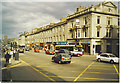
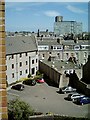
AB10 1FR is a specific residential postcode cluster situated within the Aberdeen City council area in north-east Scotland. This small holding of 4,811 m² exists at the edge of the urban sprawl, offering a taste of life near the historic Granitic city. Aberdeen itself spans the Rivers Dee and Don and has evolved from its origins as Old and New Aberdeen into Europe's offshore oil capital. The postcode benefits from a strategic coastal position that supports trade, education, and energy sectors. You are steps away from a city defined by 18th- to 20th-century grey granite buildings and a rich academic heritage. The University of Aberdeen anchors the local atmosphere, while the economy is driven by the oil and gas industry established since 1969. Daily life here involves easy access to major transport links, including the largest seaport in the north-east. While the area is compact, it sits at the gateway to significant cultural landmarks such as St. Machar's Cathedral and King's College. Living in AB10 1FR means being part of a community that balances industrial might with historic charm. The postcode connects you to key arterial routes and services without requiring travel across the entire city. This compact size ensures you are never far from essential urban amenities while maintaining a distinct residential character.
- Area Type
- Postcode
- Area Size
- 4811 m²
- Population
- Not available
- Population Density
- Not available
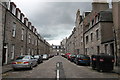
The property market in AB10 1FR is defined by the constraints of a small residential cluster covering just 4,811 m². This limited footprint means you will find properties that are part of a tight-knit residential development rather than a sprawling suburb. Specific home ownership percentages and accommodation type data are not listed for this exact postcode, but the location sits within the Aberdeen City council area, a region known for its granite architecture and university heritage. Buyers looking at this area should anticipate a mix of housing styles typical of Aberdeen's post-1969 expansion and older historic structures. The immediate surroundings likely feature detached houses, flats, or terraced homes common throughout the Granite City. Because the postcode is so small, the supply of "homes in AB10 1FR" is naturally restricted, driving a market where location and specific property features hold significant value. You are entering a market where every listing offers a rare opportunity to live in a specific niche of the city. The absence of granular tenure data suggests a stable, established residential zone rather than a volatile speculative bubble. Serious buyers will value the proximity to the city centre and major transport hubs over the size of the plot itself. This area represents a concentrated entry point into one of Scotland's most economically significant cities.
House Prices in AB10 1FR
No properties found in this postcode.
Energy Efficiency in AB10 1FR
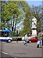
Your lifestyle in AB10 1FR is supported by a dense ring of retail and transport amenities within practical reach. You have immediate access to five major retail destinations, including Farmfoods, Sainsburys Aberdeen St., and M&S Aberdeen. These shops provide daily essentials without the need for long journeys. Transport options are exceptionally strong, with three railway stations nearby: Aberdeen Railway Station, Dyce Railway Station, and Portlethen Railway Station. This proximity ensures you can catch trains to major cities quickly or travel to nearby towns like Portlethen. The area also features one ferry terminal and two airports, Aberdeen Dyce Airport and Aberdeen Airport, giving you flexible travel options for business or leisure. You can walk or drive to Aberdeen Ferry Terminal to cross the North Sea to the mainland via NorthLink Ferries. The space between your home and these amenities is minimal, enhancing the convenience of daily life. For cultural visits, the city centre offers St. Machar's Cathedral and the world's largest granite building, Marischal College. The local economy supported by the offshore oil industry ensures these facilities remain well-maintained and relevant. You will find that the convenience of having grocery stores and major transport nodes so close by significantly impacts your daily satisfaction. Living in AB10 1FR means you can manage work, shopping, and travel with ease.
Amenities
Schools
| Rank | School | Type | Entry gender | Ages |
|---|
Explore more schools in this area
Go to Schools tabDemographics
Communities within the AB10 postcode sector reflect the broader urban nature of Aberdeen, though specific age statistics or household type breakdowns for this exact cluster are not detailed in the current records. The area exists within a demographic landscape shaped by the city's transformation from traditional fishing and textile industries to a global energy hub. Deprivation data is not included in the assessment for this specific location, yet the surrounding urban environment supports a mix of professionals, students from the University of Aberdeen, and families drawn to the oil and gas sector. The housing stock in this small residential zone typically mirrors the city's diverse accommodation needs. While precise figures on home ownership versus renting are not provided for AB10 1FR specifically, the wider Aberdeen context shows evolving patterns in property tenure. The area's residents share a connection to the Granite City's identity as a strategic coastal position for trade and education. Understanding the community requires looking at the surrounding council area where social and economic factors intersect. You can expect a population that navigates the city's dynamic shift from historical burghs to a modern industrial powerhouse. The lack of specific demographic segmentation here suggests a concentrated residential spot integrated into a larger, complex urban demographic tapestry.
Household Size
Accommodation Type
Tenure
Ethnic Group
Religion
Household Composition
Age
Household Deprivation
NS-SEC
Explore more demographic insights in this area
Go to Demographics tabPlanning
Planning Constraints
- Flood RiskPremium
- Ramsar Wetland SitesPremium
- Area of Outstanding Natural BeautyPremium
- Protected Nature ReservePremium
- Protected WoodlandPremium
- Crime & SafetyPremium