Area Overview for LS28 5RH
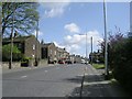
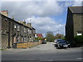
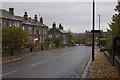
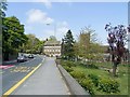
Photos of LS28 5RH
Area Information
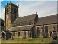
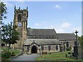
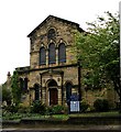
LS28 5RH is a small, compact postcode area in west Leeds, encompassing a residential cluster within the broader Calverley and Farsley ward. With a population of 1,597 spread across 4.9 hectares, it is a tightly knit community situated approximately ten miles from Leeds city centre and four miles from Bradford. The area’s character is shaped by its historical roots, including Calverley Old Hall, a 14th-century manor house, and Calverley Cutting, a 19th-century road carved through sandstone. This mix of heritage and modernity defines daily life here, where residents benefit from proximity to both urban and rural settings. The area is predominantly home to adults aged 30–64, with a median age of 47, reflecting a stable, family-oriented demographic. While the ward as a whole faces higher deprivation levels, LS28 5RH itself appears to have a balanced mix of amenities, including schools, retail, and transport links, making it a practical choice for those seeking a quieter yet connected lifestyle.
- Area Type
- Postcode
- Area Size
- 4.9 hectares
- Population
- 1597
- Population Density
- 654 people/km²
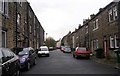
The property market in LS28 5RH is dominated by owner-occupied homes, with 72% of residents living in properties they own. The accommodation type is predominantly houses, indicating a residential area that leans towards semi-detached or detached homes rather than flats or apartments. This suggests a market that caters to families or individuals seeking space and privacy, rather than urban renters. Given the small size of the postcode area—just 4.9 hectares—the housing stock is limited, which may mean higher competition for available properties. Buyers should consider the proximity to local amenities, such as schools and transport links, as these are critical factors in a small area where expansion is constrained. The high home ownership rate also implies that the area is less influenced by rental demand, making it a stable but niche market for those prioritising long-term residency.
House Prices in LS28 5RH
Showing 42 properties
| Address | Type | Beds | Baths | Last Sale Price | Last Sale Date | |
|---|---|---|---|---|---|---|
| 14 Carr Road, Calverley, Pudsey, LS28 5RH | Terraced | 4 | 2 | £410,000 | Sep 2025 | |
| 18 Carr Road, Calverley, Pudsey, LS28 5RH | Terraced | 3 | 1 | £320,000 | Jan 2025 | |
| 42 Carr Road, Calverley, Pudsey, LS28 5RH | Terraced | 3 | 1 | £367,500 | Jun 2024 | |
| 50 Carr Road, Calverley, Pudsey, LS28 5RH | Terraced | 3 | 1 | £307,500 | Nov 2023 | |
| 56 Carr Road, Calverley, Pudsey, LS28 5RH | Semi-detached | 3 | 1 | £320,000 | Jul 2023 | |
| 64 Carr Road, Calverley, Pudsey, LS28 5RH | house | 6 | 1 | £355,000 | Feb 2023 | |
| 28 Carr Road, Calverley, Pudsey, LS28 5RH | Terraced | 5 | 2 | £660,000 | Oct 2022 | |
| 52 Carr Road, Calverley, Pudsey, LS28 5RH | house | 3 | - | £337,500 | Jun 2021 | |
| 16 Carr Road, Calverley, Pudsey, LS28 5RH | Terraced | 4 | 1 | £377,500 | Apr 2021 | |
| 36 Carr Road, Calverley, Pudsey, LS28 5RH | house | 3 | - | £598,000 | Mar 2021 |
Energy Efficiency in LS28 5RH
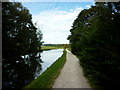
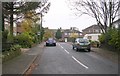
The lifestyle in LS28 5RH is shaped by its proximity to a range of amenities within practical reach. Retail options include major supermarkets such as Asda Greengates, Sainsburys Bradford, and Farmfoods Eccleshill, ensuring convenience for daily shopping needs. The area’s rail connections to Apperley Bridge, New Pudsey, and other stations provide easy access to public transport, while the nearby Leeds Bradford Airport offers regional and international travel options. Though the data does not detail parks or leisure facilities, the historical landmarks of Calverley Old Hall and Calverley Cutting suggest a blend of heritage and natural features. The compact nature of the postcode means that amenities are concentrated, reducing the need for long commutes. This convenience, combined with the area’s stable community and low crime risk, supports a lifestyle that balances accessibility with a quieter, more contained environment.
Amenities
Schools
Residents of LS28 5RH have access to three primary schools within the immediate vicinity. Calverley Parkside Primary School is listed twice in the data, though both entries appear to reference the same institution, which holds an Ofsted rating of ‘good’. Additionally, Calverley Church of England Voluntary Aided Primary School is also present, with a ‘good’ Ofsted rating. These schools provide a range of educational options for families, though the absence of secondary schools in the data suggests that parents may need to look further afield for secondary education. The presence of two primary schools with strong ratings indicates a focus on early education, which is beneficial for families with young children. However, the lack of detailed information about school capacity or catchment areas means prospective buyers should verify whether their preferred school is within the local authority’s admissions criteria.
| Rank | School | Type | Entry gender | Ages |
|---|
Explore more schools in this area
Go to Schools tabDemographics
The population of LS28 5RH is 1,597, with a median age of 47 and the majority of residents falling within the 30–64 age range. This suggests a mature, established community with a strong presence of middle-aged adults. Home ownership is high at 72%, indicating a stable housing market where most residents live in their own homes rather than renting. The primary accommodation type is houses, reflecting a suburban or semi-rural setting rather than high-density housing. The predominant ethnic group is White, comprising the majority of the population, though specific figures for minority groups are not detailed. The area’s demographic profile aligns with a low-risk, low-volatility environment, where residents are likely to be long-term residents with established roots. This stability is reinforced by the low crime risk score of 77/100, suggesting a safe and predictable living environment.
Household Size
Accommodation Type
Tenure
Ethnic Group
Religion
Household Composition
Age
Household Deprivation
NS-SEC
Explore more demographic insights in this area
Go to Demographics tabPlanning
Planning Constraints
- Flood RiskPremium
- Ramsar Wetland SitesPremium
- Area of Outstanding Natural BeautyPremium
- Protected Nature ReservePremium
- Protected WoodlandPremium