Area Overview for LS28 5HW
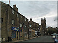
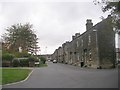
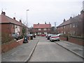
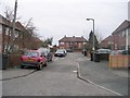
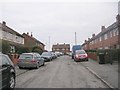
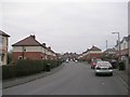
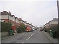
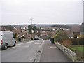
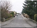
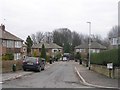
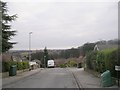
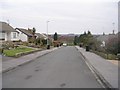
Photos of LS28 5HW
Area Information
LS28 5HW is a compact residential postcode in west Leeds, part of the larger Calverley and Farsley ward. Covering just 1.0 hectare, it is densely populated, with 1,543 residents living at a density of 152,550 people per square kilometre. This small area sits within a historically significant region, bordered by the A657 road and near the village of Calverley, which features the 14th-century Calverley Old Hall. The ward itself, with a population of 24,595, has a median age of 40, though LS28 5HW’s residents average 47 years old. The area is predominantly White, with 57% of homes owner-occupied, reflecting a settled community. Daily life here is shaped by proximity to nearby towns like Pudsey and Bradford, with easy access to retail, rail, and transport links. While the area lacks major commercial hubs, its small size and high connectivity make it appealing for those seeking a quieter, well-served suburban lifestyle.
- Area Type
- Postcode
- Area Size
- 1.0 hectares
- Population
- 1543
- Population Density
- 5544 people/km²
LS28 5HW is a small area with a housing stock predominantly consisting of houses, reflecting a traditional suburban layout. With 57% of properties owner-occupied, it is not a rental-heavy market, suggesting a focus on long-term residency. The compact size of the postcode means the housing stock is limited, and buyers should consider nearby areas for more options. The high broadband score (100) and good mobile coverage (85) make it attractive for remote workers, though the area’s small size may limit property diversity. Given the high population density, properties here are likely to be in demand, particularly for those prioritising proximity to transport links and local amenities.
House Prices in LS28 5HW
Showing 34 properties
| Address | Type | Beds | Baths | Last Sale Price | Last Sale Date | |
|---|---|---|---|---|---|---|
| Flat 6, Fairfield House, The Gardens, Farsley, Pudsey, LS28 5HW | Flat | 2 | - | - | - | |
| Flat 1, Fairfield House, The Gardens, Farsley, Pudsey, LS28 5HW | Flat | - | - | - | - | |
| Flat 5, Fairfield House, The Gardens, Farsley, Pudsey, LS28 5HW | Flat | - | - | - | - | |
| Flat 2, Fairfield House, The Gardens, Farsley, Pudsey, LS28 5HW | Flat | 1 | - | - | - | |
| Flat 3, Fairfield House, The Gardens, Farsley, Pudsey, LS28 5HW | Flat | - | - | - | - | |
| Flat 4, Fairfield House, The Gardens, Farsley, Pudsey, LS28 5HW | Flat | - | - | - | - | |
| 36 The Gardens, Farsley, Pudsey, LS28 5HW | Bungalow | - | - | - | - | |
| 7 The Gardens, Farsley, Pudsey, LS28 5HW | Flat | - | - | - | - | |
| 18 The Gardens, Farsley, Pudsey, LS28 5HW | Terraced | - | - | - | - | |
| 14 The Gardens, Farsley, Pudsey, LS28 5HW | Bungalow | - | - | - | - |
Energy Efficiency in LS28 5HW
LS28 5HW offers a range of nearby amenities, including retail options like Co-op Farsley, Asda Pudsey, and M&S Pudsey, all within practical reach. The area’s rail stations provide easy access to shopping, dining, and leisure in Pudsey and Bradford. While the postcode itself is small, the surrounding region includes historical landmarks like Calverley Old Hall and the 19th-century Calverley Cutting, adding cultural value. The combination of local shops, transport links, and proximity to larger towns ensures a convenient lifestyle, blending suburban tranquillity with urban accessibility.
Amenities
Schools
The nearest school to LS28 5HW is Farsley Farfield Infant School, a primary school serving the area. While no Ofsted rating is provided, its presence indicates access to early education for local families. The absence of secondary schools in the immediate vicinity means families may need to look further afield for comprehensive schooling. However, the proximity to Pudsey and Bradford, both of which have larger educational networks, could mitigate this. The mix of schools in the broader region suggests a range of options for different age groups, though parents should verify availability and catchment areas for secondary education.
| Rank | School | Type | Entry gender | Ages |
|---|
Explore more schools in this area
Go to Schools tabDemographics
The population of LS28 5HW is 1,543, with a median age of 47 and the majority of residents aged 30–64. This suggests a mature, stable community, with 57% of homes owner-occupied. The predominant accommodation type is houses, indicating a mix of family homes and single-occupancy properties. The area is ethnically homogenous, with White residents making up the majority. While the broader Calverley and Farsley ward has a deprivation score placing it near the bottom of Leeds for deprivation, specific data for LS28 5HW is not provided. However, the high home ownership rate and proximity to amenities suggest a relatively stable quality of life. The age profile indicates a community with established residents, potentially with fewer young families compared to other areas.
Household Size
Accommodation Type
Tenure
Ethnic Group
Religion
Household Composition
Age
Household Deprivation
NS-SEC
Explore more demographic insights in this area
Go to Demographics tabPlanning
Planning Constraints
- Flood RiskPremium
- Ramsar Wetland SitesPremium
- Area of Outstanding Natural BeautyPremium
- Protected Nature ReservePremium
- Protected WoodlandPremium