Area Overview for LS25 5AL
Photos of LS25 5AL
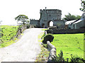
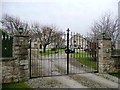
![Steeton Hall Gateway [or Steeton Gatehouse] in LS25 5AL](https://images.propbar.co.uk/images/geograph/27/36/2736639_120.jpg)
30 photos from this area
Area Information
Key information about the LS25 5AL including its size, population, and administrative classification.
- Area Type
- Postcode
- Area Size
- 8.2 hectares
- Population
- 1414
- Population Density
- 79 people/km²
House Prices in LS25 5AL
5
Properties
£240,749
Average Sold Price
£175,000
Lowest Price
£299,995
Highest Price
Showing 5 properties
| Address | Type | Beds | Baths | Last Sale Price | Last Sale Date | |
|---|---|---|---|---|---|---|
| 80 Westfield Lane, South Milford, LS25 5AL | Semi-detached | 3 | 1 | £254,000 | Oct 2024 | |
| 82 Westfield Lane, South Milford, LS25 5AL | Semi-detached | 3 | 1 | £175,000 | Jun 2014 | |
| 84 Westfield Lane, South Milford, LS25 5AL | Detached | - | - | £299,995 | Sep 2008 | |
| 86 Westfield Lane, South Milford, LS25 5AL | Detached | - | - | £234,000 | Mar 2006 | |
| Westfield Farm, Westfield Lane, South Milford, LS25 5AL | Farm | - | - | - | - |
Energy Efficiency in LS25 5AL
Amenities
Schools
| Rank | School | Type | Entry gender | Ages |
|---|
Explore more schools in this area
Go to Schools tabDemographics
Household Size
Two person
most common
Accommodation Type
Houses
most common
Tenure
76
majority
Ethnic Group
White
most common
Religion
N/A
most common
Household Composition
N/A
most common
Age
47
median
Adults (30-64 years)
most common
Household Deprivation
N/A
with no deprivation
NS-SEC
44
in Lower managerial occupations
Explore more demographic insights in this area
Go to Demographics tabPlanning
Planning Constraints
- Flood RiskPremium
- Ramsar Wetland SitesPremium
- Area of Outstanding Natural BeautyPremium
- Protected Nature ReservePremium
- Protected WoodlandPremium