Area Overview for DN37 7JE
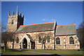
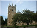
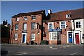
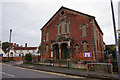
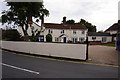
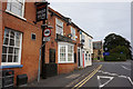
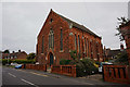
Photos of DN37 7JE


Area Information
DN37 7JE is a small, tightly knit residential postcode in England, covering just 11 hectares and home to 1,428 people. Its compact size means it feels more like a village than a sprawling suburb, with a population density of 91 people per square kilometre. This area is defined by its quiet, low-density living, where homes are predominantly single-family properties. Daily life here is shaped by proximity to nearby amenities and a community that leans heavily on local services. The area’s modest scale makes it easy to navigate, with no sprawling developments or complex infrastructure. While it lacks the vibrancy of larger urban centres, its simplicity offers a peaceful alternative for those seeking a slower pace. The mix of older and newer housing, combined with a median age of 47, suggests a stable, long-term resident base. For buyers, this area appeals to those prioritising space, privacy, and a sense of local identity over high population density. Its location, while not near major cities, is served by multiple rail links, making it accessible for commuters.
- Area Type
- Postcode
- Area Size
- 11.0 hectares
- Population
- 1428
- Population Density
- 91 people/km²
The property market in DN37 7JE is characterised by a high rate of home ownership, with 86% of properties owned by their occupants. This suggests a stable, long-term resident base with little turnover, which can be appealing to buyers seeking a sense of permanence. The accommodation types are predominantly houses, reflecting the area’s low-density, residential focus. This contrasts with areas dominated by flats or rental properties, where tenant mobility is higher. The small size of the postcode means the housing stock is limited, which could make the market competitive for buyers. However, the presence of multiple railway stations within practical reach may attract commuters looking for a balance between rural living and urban connectivity. For those considering purchase, the area’s small size means properties are likely to be distinct, with fewer similarities to surrounding areas. Buyers should also consider the limited number of homes available, which may affect both choice and negotiation power.
House Prices in DN37 7JE
Showing 1 properties
| Address | Type | Beds | Baths | Last Sale Price | Last Sale Date | |
|---|---|---|---|---|---|---|
| Kingsfield House, Caistor Road, Laceby, DN37 7JE | Detached | 5 | 2 | £615,000 | Jun 2018 |
Energy Efficiency in DN37 7JE
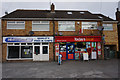
The lifestyle in DN37 7JE is shaped by its proximity to five retail outlets, including Lincolnshire Co-operative Co-op hire, Spar, and Morrisons Grange. These shops provide essential services for daily living, from groceries to household items, reducing the need for long trips to larger centres. The area’s rail network, with stations such as Healing and Great Coates, offers easy access to nearby towns for more extensive shopping, dining, or leisure activities. While the data does not mention parks or recreational spaces, the low population density and absence of environmental constraints suggest potential for open, green areas. The presence of multiple rail links also implies a connection to cultural or entertainment hubs beyond the immediate postcode. For residents, this balance of local amenities and regional accessibility creates a practical, low-stress lifestyle, ideal for those who value convenience without the hustle of urban living.
Amenities
Schools
The only school listed near DN37 7JE is Best Futures, a special school with an Ofsted rating of satisfactory. This indicates that the area’s educational provision is focused on supporting students with specific needs, rather than offering a range of primary or secondary schools. Families with children requiring specialist education may find this school suitable, but those seeking mainstream schooling would need to look further afield. The absence of other schools in the data suggests that parents may need to travel to nearby towns for comprehensive education options. This could be a consideration for prospective buyers, particularly those with young children or those prioritising a wider range of educational facilities. The satisfactory Ofsted rating implies that the school meets basic standards but may not excel in areas such as academic performance or pastoral care.
| Rank | School | Type | Entry gender | Ages |
|---|
Explore more schools in this area
Go to Schools tabDemographics
The community in DN37 7JE is predominantly composed of adults aged 30–64, with a median age of 47. This suggests a mature, established population, many of whom are likely to have lived in the area for years. Home ownership is high, with 86% of residents owning their homes, indicating a stable housing market and long-term commitment to the area. The accommodation types are largely houses, reflecting the low-density nature of the postcode. The predominant ethnic group is White, which aligns with the broader demographic trends in rural and semi-rural England. The population density of 91 people per square kilometre is relatively low, contributing to a more spread-out, less crowded environment. This profile suggests a community focused on family stability and long-term residency, with fewer transient populations. The absence of specific deprivation data means no direct commentary on economic hardship, but the high home ownership rate and age profile imply a generally secure financial situation for most residents.
Household Size
Accommodation Type
Tenure
Ethnic Group
Religion
Household Composition
Age
Household Deprivation
NS-SEC
Explore more demographic insights in this area
Go to Demographics tabPlanning
Planning Constraints
- Flood RiskPremium
- Ramsar Wetland SitesPremium
- Area of Outstanding Natural BeautyPremium
- Protected Nature ReservePremium
- Protected WoodlandPremium