Area Overview for DN37 7DG
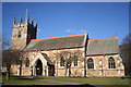
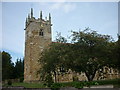
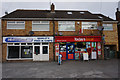
Photos of DN37 7DG


Area Information
DN37 7DG is a compact residential cluster in England, covering 13.7 hectares with a population of 1428 people. Its low population density of 91 people per square kilometre suggests a quiet, spacious living environment. The area is characterised by a mature community, with a median age of 47 and a strong presence of adults aged 30–64. This demographic profile indicates a stable, established neighbourhood where many residents are likely to be long-term homeowners. The area’s small size means it is likely to feel close-knit, with limited development and a focus on residential living. While it lacks major urban amenities, its proximity to rail networks and basic retail services makes it practical for daily life. The low flood risk and absence of protected natural sites suggest minimal environmental constraints, though standard security measures are advisable due to the moderate crime risk. For those seeking a peaceful, low-maintenance lifestyle with access to essential services, DN37 7DG offers a straightforward, no-frills option.
- Area Type
- Postcode
- Area Size
- 13.7 hectares
- Population
- 1428
- Population Density
- 91 people/km²
The property market in DN37 7DG is dominated by owner-occupied homes, with 86% of residents living in houses. This suggests a market skewed towards long-term homeownership rather than rental properties. The prevalence of houses over flats or apartments indicates a focus on family-friendly, spacious living, which may appeal to those prioritising privacy and outdoor space. Given the area’s small size and limited development, property availability is likely constrained, making it a niche market for buyers seeking a quiet, established residential environment. The high home ownership rate also implies stable property values, though the lack of commercial or mixed-use development may limit future growth. For buyers, this means a focus on existing homes rather than new builds, with potential for long-term investment in a low-risk, low-maintenance area.
House Prices in DN37 7DG
Showing 13 properties
| Address | Type | Beds | Baths | Last Sale Price | Last Sale Date | |
|---|---|---|---|---|---|---|
| 3 Grange Avenue, Laceby, DN37 7DG | Bungalow | 3 | 1 | £159,000 | Aug 2025 | |
| 16 Grange Avenue, Laceby, DN37 7DG | Bungalow | 3 | 1 | £272,000 | Aug 2023 | |
| 5 Grange Avenue, Laceby, DN37 7DG | Bungalow | - | - | £195,000 | Feb 2021 | |
| 10 Grange Avenue, Laceby, DN37 7DG | Bungalow | 3 | 1 | £185,000 | Jul 2020 | |
| 2 Grange Avenue, Laceby, DN37 7DG | Bungalow | - | - | £165,000 | Nov 2017 | |
| 12 Grange Avenue, Laceby, DN37 7DG | Bungalow | - | - | £155,000 | Apr 2017 | |
| 18 Grange Avenue, Laceby, DN37 7DG | house | 4 | - | £300,000 | Mar 2011 | |
| 6 Grange Avenue, Laceby, DN37 7DG | Detached | - | - | £155,000 | May 2006 | |
| 7 Grange Avenue, Laceby, DN37 7DG | Detached | - | - | £59,000 | Apr 2001 | |
| 4 Grange Avenue, Laceby, DN37 7DG | Bungalow | - | - | £60,000 | Oct 1999 |
Energy Efficiency in DN37 7DG
The lifestyle in DN37 7DG is shaped by its proximity to essential retail and transport hubs. Within practical reach are five retail outlets, including Lincolnshire Co-operative Co-op hire, Spar, and Morrisons Grange, offering everyday shopping needs. The area’s rail network, with stations at Great Coates, Healing, and Stallingborough, provides access to broader regional services, enhancing convenience for commuting or leisure travel. While the data does not mention parks or leisure facilities, the lack of protected natural sites or planning constraints suggests minimal restrictions on local amenities. The combination of retail access and rail connectivity supports a functional, low-maintenance lifestyle, ideal for those prioritising practicality over extensive recreational options.
Amenities
Schools
The nearest school to DN37 7DG is Best Futures, a special school with an Ofsted rating of satisfactory. This indicates that the area is served by educational provisions tailored to students with specific needs, though no mainstream schools are listed in the data. The presence of a special school suggests that families with children requiring additional support may find the area suitable, while those seeking traditional primary or secondary education may need to look further afield. The absence of other schools highlights a potential limitation for families prioritising a range of educational options. However, the satisfactory rating at Best Futures implies that the school meets baseline standards for safety, teaching quality, and student outcomes, providing a reliable resource for residents.
| Rank | School | Type | Entry gender | Ages |
|---|
Explore more schools in this area
Go to Schools tabDemographics
The community in DN37 7DG is predominantly composed of adults aged 30–64, reflecting a mature population with a median age of 47. Home ownership is high, with 86% of residents living in owner-occupied properties, indicating a stable, long-term demographic. The accommodation type is primarily houses, which aligns with the area’s low population density and suggests a focus on family homes rather than apartments or flats. The predominant ethnic group is White, though no data is provided on other ethnicities or diversity metrics. This demographic profile implies a community with strong generational continuity, where many residents may have lived in the area for years. The absence of specific data on deprivation or socioeconomic diversity means the area’s quality of life can be inferred from its infrastructure and services, which appear to meet basic needs without significant strain.
Household Size
Accommodation Type
Tenure
Ethnic Group
Religion
Household Composition
Age
Household Deprivation
NS-SEC
Explore more demographic insights in this area
Go to Demographics tabPlanning
Planning Constraints
- Flood RiskPremium
- Ramsar Wetland SitesPremium
- Area of Outstanding Natural BeautyPremium
- Protected Nature ReservePremium
- Protected WoodlandPremium