Area Overview for DN37 7DP
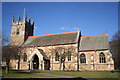
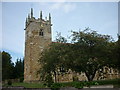
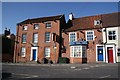
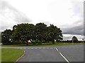
Photos of DN37 7DP


Area Information
Living in DN37 7DP offers a quiet, residential experience within a small cluster of homes. The area covers just 2.1 hectares and is home to 1,428 residents, resulting in a low population density of 91 people per square kilometre. This compact community is characterised by a mature demographic, with a median age of 47 and a strong presence of adults aged 30–64. The area is predominantly owner-occupied, with 86% of homes owned by residents, and houses make up the majority of accommodation. Daily life here is defined by proximity to essential services, including five retail outlets and multiple railway stations. While the area lacks large-scale amenities, its small size ensures a close-knit environment. Residents benefit from good digital connectivity, with broadband and mobile scores in the upper range, supporting both work and leisure. DN37 7DP is ideal for those seeking a stable, low-risk environment with practical access to transport and basic retail, though its limited scale means it is best suited for those prioritising convenience over sprawling urban or rural settings.
- Area Type
- Postcode
- Area Size
- 2.1 hectares
- Population
- 1428
- Population Density
- 91 people/km²
The property market in DN37 7DP is dominated by owner-occupied homes, with 86% of properties owned by residents. This high rate of home ownership suggests a stable, long-term community with limited rental activity. The area is primarily composed of houses, which are more common than flats or other forms of accommodation. This housing stock is likely to appeal to families or individuals seeking traditional, spacious homes rather than modern apartments. Given the area’s small size, the immediate surroundings may offer more options for buyers, though the cluster of homes indicates a limited supply. The predominance of houses also implies that the market is less influenced by short-term rental trends or student housing. For buyers, this means a focus on established properties with potential for long-term value, though the small scale of the area may require considering nearby towns for broader choices.
House Prices in DN37 7DP
Showing 11 properties
| Address | Type | Beds | Baths | Last Sale Price | Last Sale Date | |
|---|---|---|---|---|---|---|
| Eastview, Grimsby Road, Laceby, DN37 7DP | Semi-detached | - | - | £164,000 | Jun 2019 | |
| Ivydene, Grimsby Road, Laceby, DN37 7DP | Semi-detached | - | - | £176,000 | Jun 2019 | |
| Coney Greens, Grimsby Road, Laceby, DN37 7DP | Detached | 4 | 3 | £335,000 | Apr 2019 | |
| Unit 8, Grimsby Road, Laceby, DN37 7DP | office_workshop | - | - | - | - | |
| Design And Build Contracts, Dbc House, Grimsby Road, Laceby, DN37 7DP | Office | - | - | - | - | |
| Laceby Business Park, Grimsby Road, Laceby, DN37 7DP | Office | - | - | - | - | |
| Mercantile Timber, Unit 3, Grimsby Road, Laceby, DN37 7DP | Office | - | - | - | - | |
| Norske Interiors Ltd, Suite 1, Dbc House, Grimsby Road, Laceby, DN37 7DP | Office | - | - | - | - | |
| Humbercare Dbc House Offices And Premises, Grimsby Road, Laceby, DN37 7DP | Office | - | - | - | - | |
| Acl House Offices And Premises, Grimsby Road, Laceby, DN37 7DP | Office | - | - | - | - |
Energy Efficiency in DN37 7DP
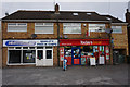
Daily life in DN37 7DP is shaped by its proximity to essential retail and transport hubs. Five retail outlets, including Lincolnshire Co-operative Co-op, Spar, and Morrisons Grange, provide access to groceries and everyday necessities. These shops cater to the needs of a small, close-knit community, ensuring convenience without the bustle of larger centres. The area’s railway stations—Great Coates, Healing, and Stallingborough—offer connections to nearby towns and cities, facilitating both commuting and leisure travel. While the area lacks large parks or entertainment venues, its compact nature means amenities are within practical reach. The combination of retail access and transport links supports a lifestyle that balances simplicity with functional connectivity, making it suitable for those who prioritise ease of access over expansive leisure options.
Amenities
Schools
The nearest school to DN37 7DP is Best Futures, a special school with an Ofsted rating of satisfactory. This institution caters to students with specific educational needs, though no other schools are listed in the data. The presence of a special school suggests that families with children requiring tailored support may find this area suitable. However, those seeking mainstream education for their children would need to look beyond DN37 7DP, as no primary or secondary schools are mentioned. The single school available does not provide a comprehensive range of educational options, which could be a limitation for some households. Parents should consider the proximity of other schools in nearby areas, as the current setup may not meet all family needs.
| Rank | School | Type | Entry gender | Ages |
|---|
Explore more schools in this area
Go to Schools tabDemographics
The community in DN37 7DP is predominantly composed of adults aged 30–64, with a median age of 47. This suggests a mature, established population, likely with long-term ties to the area. Home ownership is high, at 86%, indicating a stable housing market with minimal rental activity. The area is largely composed of houses, which aligns with the demographic profile of older, family-oriented residents. The predominant ethnic group is White, though specific data on diversity is not provided. The population density of 91 people per square kilometre is low, contributing to a less congested living environment. This combination of factors—older residents, high home ownership, and a focus on single-family homes—creates a community that values privacy and stability. However, the limited data on deprivation or income levels means the area’s economic profile remains partially unexplored.
Household Size
Accommodation Type
Tenure
Ethnic Group
Religion
Household Composition
Age
Household Deprivation
NS-SEC
Explore more demographic insights in this area
Go to Demographics tabPlanning
Planning Constraints
- Flood RiskPremium
- Ramsar Wetland SitesPremium
- Area of Outstanding Natural BeautyPremium
- Protected Nature ReservePremium
- Protected WoodlandPremium