Area Overview for DN18 5EU
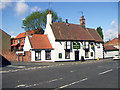
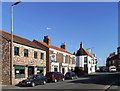
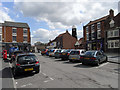
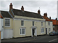
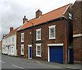
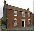
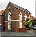
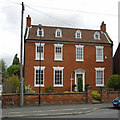
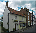
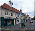
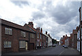
Photos of DN18 5EU

Area Information
DN18 5EU is a compact residential postcode in England, covering just 1.1 hectares and home to 2,066 residents. Its high population density—182,520 people per square kilometre—reflects a tightly knit community. The area is characterised by a mix of housing stock, with a strong emphasis on owner-occupied homes. Daily life here is shaped by proximity to local amenities, including retail outlets, rail stations, and a nearby airport. The presence of Barton St Peter’s CofE Primary School, rated good by Ofsted, suggests a family-friendly environment. While the area is small, it offers practical access to essential services, making it suitable for those prioritising convenience over expansive space. The demographic profile, with a median age of 47 and a majority of adults aged 30–64, indicates a stable, mature community. For buyers, DN18 5EU balances proximity to infrastructure with a sense of local cohesion, though its limited size means housing options are constrained.
- Area Type
- Postcode
- Area Size
- 1.1 hectares
- Population
- 2066
- Population Density
- 2857 people/km²
DN18 5EU is primarily an owner-occupied area, with 69% of residents living in homes they own. The accommodation type is predominantly houses, which is unusual for a small postcode but suggests a mix of detached or semi-detached properties. Given the area’s limited size—just 1.1 hectares—the housing stock is likely to be tightly concentrated, potentially limiting availability for buyers. The high home ownership rate indicates a stable market where properties may hold value over time. However, the small geographic footprint means that the immediate surroundings, rather than the area itself, are likely to offer more housing diversity. Buyers should consider the proximity to nearby towns for broader property options, while the local market remains focused on owner-occupied, family-sized homes.
House Prices in DN18 5EU
Showing 30 properties
| Address | Type | Beds | Baths | Last Sale Price | Last Sale Date | |
|---|---|---|---|---|---|---|
| 18 Whitecross Street, Barton Upon Humber, DN18 5EU | Detached | 4 | 2 | £285,000 | Dec 2022 | |
| 41 Whitecross Street, Barton Upon Humber, DN18 5EU | Terraced | 2 | 1 | £420,000 | May 2022 | |
| 12 Whitecross Street, Barton Upon Humber, DN18 5EU | house | 4 | - | £143,800 | Sep 2020 | |
| 30 Whitecross Street, Barton Upon Humber, DN18 5EU | Terraced | 2 | 1 | £66,000 | Sep 2020 | |
| 24 Whitecross Street, Barton Upon Humber, DN18 5EU | Terraced | 3 | 2 | £257,000 | Jun 2019 | |
| 57 Whitecross Street, Barton Upon Humber, DN18 5EU | house | 3 | 1 | £180,000 | Oct 2018 | |
| Hoppers Club, 14A Whitecross Street, Barton Upon Humber, DN18 5EU | Detached | - | - | £160,000 | Oct 2017 | |
| 26 Whitecross Street, Barton Upon Humber, DN18 5EU | Terraced | 2 | 1 | £70,000 | Aug 2017 | |
| 20 Whitecross Street, Barton Upon Humber, DN18 5EU | house | 5 | - | £270,000 | Sep 2012 | |
| 14 Whitecross Street, Barton Upon Humber, DN18 5EU | Semi-detached | 5 | - | £270,000 | Jan 2012 |
Energy Efficiency in DN18 5EU
Living in DN18 5EU offers access to a range of nearby amenities, including five retail outlets such as Co-op Barton, Morrisons Daily Barton-on, and Spar. These shops provide convenience for daily essentials, reducing the need for long trips. The area’s rail stations connect residents to broader networks, while Brough Airport offers regional travel options. Though the postcode is small, the proximity to these amenities fosters a practical lifestyle. The presence of a primary school and retail options suggests a community focused on local needs. However, the limited size of DN18 5EU means that leisure and recreational facilities may be sparse, requiring residents to venture to nearby towns for more extensive options.
Amenities
Schools
The nearest school to DN18 5EU is Barton St Peter’s CofE Primary School, which provides education for younger children. Rated good by Ofsted, it offers a reliable option for families with primary-aged children. The absence of secondary schools in the immediate area means residents may need to look to nearby towns for further education. The presence of a single primary school suggests a focus on local schooling, which can be advantageous for families seeking a tight-knit community. However, the lack of additional educational institutions may require careful planning for older children. For those prioritising primary education, Barton St Peter’s CofE Primary School is a key asset of the area.
| Rank | School | Type | Entry gender | Ages |
|---|
Explore more schools in this area
Go to Schools tabDemographics
The population of DN18 5EU is predominantly adults aged 30–64, with a median age of 47. This suggests a mature, established community with a strong focus on long-term residency. Home ownership is high at 69%, indicating a stable housing market where most residents are likely to be homeowners rather than renters. The primary accommodation type is houses, which aligns with the area’s compact footprint. The predominant ethnic group is White, though no specific diversity metrics are provided. The age profile implies a low proportion of young families or retirees, which may influence local services and amenities. With no data on deprivation levels, the quality of life here appears to be shaped by the availability of nearby schools and transport links, which are critical for daily living.
Household Size
Accommodation Type
Tenure
Ethnic Group
Religion
Household Composition
Age
Household Deprivation
NS-SEC
Explore more demographic insights in this area
Go to Demographics tabPlanning
Planning Constraints
- Flood RiskPremium
- Ramsar Wetland SitesPremium
- Area of Outstanding Natural BeautyPremium
- Protected Nature ReservePremium
- Protected WoodlandPremium