Area Overview for DN17 2HZ
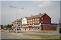
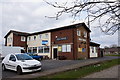
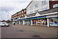
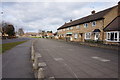
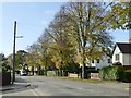
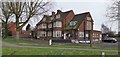
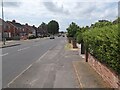
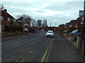
Photos of DN17 2HZ


Area Information
DN17 2HZ is a compact residential postcode in North Lincolnshire, part of the Brumby electoral ward in Scunthorpe. Covering just 5,631 square metres, the area is densely populated, with 1,524 residents living in a small cluster of homes. The community is predominantly composed of adults aged 30–64, reflecting a mature demographic with a median age of 47. This small postcode sits within the Scunthorpe parliamentary constituency and is served by nearby rail stations, offering connectivity to the wider region. While the area lacks historical detail beyond its establishment in 1980, its proximity to Scunthorpe’s infrastructure and amenities makes it a practical choice for those seeking a quiet, compact living environment. The high population density contrasts with the limited natural constraints, as no protected landscapes or wetlands encroach on the area. For buyers, DN17 2HZ represents a niche market, where homes are primarily owner-occupied and the community is tightly knit, with local schools and retail options within reach.
- Area Type
- Postcode
- Area Size
- 5631 m²
- Population
- 1524
- Population Density
- 5112 people/km²
The property market in DN17 2HZ is defined by a 46% home ownership rate, with houses being the primary accommodation type. This suggests a community where most residents are long-term homeowners, though the relatively low ownership rate indicates a significant rental market. The small area size and high population density mean properties are likely to be modest in scale, with limited space for expansion. For buyers, this presents a niche opportunity: the area is not dominated by high-end properties or speculative investment, but rather by family homes suited to the mature demographic. The proximity to Scunthorpe’s rail network and retail options adds practical value, though the compact nature of the postcode means buyers must consider immediate surroundings for additional amenities. The lack of flats or newer developments implies a traditional housing stock, which may appeal to those seeking stability over modernization.
House Prices in DN17 2HZ
Showing 14 properties
| Address | Type | Beds | Baths | Last Sale Price | Last Sale Date | |
|---|---|---|---|---|---|---|
| 16 Scawby Road, Scunthorpe, DN17 2HZ | Semi-detached | 3 | 1 | £120,000 | Oct 2024 | |
| 2 Scawby Road, Scunthorpe, DN17 2HZ | Semi-detached | 3 | - | £74,750 | Oct 2011 | |
| 8 Scawby Road, Scunthorpe, DN17 2HZ | house | - | - | £112,000 | Sep 2007 | |
| 5 Scawby Road, Scunthorpe, DN17 2HZ | Semi-detached | - | - | - | - | |
| 7 Scawby Road, Scunthorpe, DN17 2HZ | Semi-detached | - | - | - | - | |
| 11 Scawby Road, Scunthorpe, DN17 2HZ | Terraced | - | - | - | - | |
| 1 Scawby Road, Scunthorpe, DN17 2HZ | Semi-detached | - | - | - | - | |
| 12 Scawby Road, Scunthorpe, DN17 2HZ | Semi-detached | - | - | - | - | |
| 3 Scawby Road, Scunthorpe, DN17 2HZ | house | - | - | - | - | |
| 6 Scawby Road, Scunthorpe, DN17 2HZ | house | - | - | - | - |
Energy Efficiency in DN17 2HZ
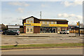
The lifestyle in DN17 2HZ is shaped by its proximity to retail and transport hubs. Nearby shops include Lincolnshire Co-operative Co, Heron Riddings, and Tesco Ashby, offering everyday essentials within practical reach. These retail options support a self-contained daily life, reducing the need for long trips to larger centres. The rail network, with stations at Scunthorpe, Althorpe, and Kirton Lindsey, provides access to broader regional connectivity. While the area lacks large parks or leisure facilities, its compact size fosters a close-knit community where amenities are concentrated. The presence of multiple schools and retail spots suggests a balance between practicality and local convenience. For residents, this means a lifestyle focused on accessibility, with essential services and transport links within walking or short driving distance.
Amenities
Schools
Residents of DN17 2HZ have access to three primary schools: Willoughby Road Primary School, Riddings Junior School, and Willoughby Road Primary Academy, which holds an Ofsted rating of 'good'. These institutions provide a range of educational options for young families, with two schools operating under the same name, suggesting possible mergers or shared facilities. The presence of multiple primary schools within the area indicates a focus on local education, reducing the need for long commutes. For families prioritizing school quality, the 'good' rating at Willoughby Road Primary Academy is a positive indicator. However, the absence of secondary schools in the immediate vicinity means students may need to travel to nearby towns for further education. The concentration of primary schools supports a community-centric approach to schooling, aligning with the area’s compact, residential character.
| Rank | School | Type | Entry gender | Ages |
|---|
Explore more schools in this area
Go to Schools tabDemographics
The population of DN17 2HZ is 1,524, with a median age of 47, indicating a mature community. The most common age range is adults aged 30–64, suggesting a stable demographic with fewer young families. Home ownership stands at 46%, meaning nearly half of residents live in properties they own, while the remaining 54% are likely to be renters. The area is predominantly composed of houses, with no data on flats or other accommodation types. The predominant ethnic group is White, with no specific figures provided on other ethnicities. This demographic profile suggests a community focused on long-term residency, with a low turnover of residents. The high population density—270,654 people per square kilometre—reflects the compact nature of the postcode, where limited space accommodates a large number of households. For prospective buyers, this density may influence property availability and the character of local interactions, with a strong emphasis on established, owner-occupied homes.
Household Size
Accommodation Type
Tenure
Ethnic Group
Religion
Household Composition
Age
Household Deprivation
NS-SEC
Explore more demographic insights in this area
Go to Demographics tabPlanning
Planning Constraints
- Flood RiskPremium
- Ramsar Wetland SitesPremium
- Area of Outstanding Natural BeautyPremium
- Protected Nature ReservePremium
- Protected WoodlandPremium