Area Overview for DN17 2EQ
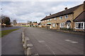
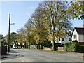
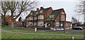
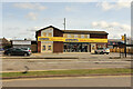
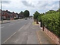
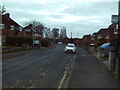
Photos of DN17 2EQ


Area Information
DN17 2EQ is a compact residential postcode in Scunthorpe, North Lincolnshire, covering 7,446 square metres and home to 1,433 residents. Its high population density of 192,464 people per square kilometre reflects its small, tightly clustered nature, typical of urban or semi-urban areas. The area falls within the Brumby Ward, a unitary authority division with a population of around 1,452, and is part of the Scunthorpe parliamentary constituency. While historical details are sparse, the DN17 postcode has been in use since 1980, suggesting a long-standing residential character. Daily life here is shaped by its proximity to retail and transport hubs, with nearby shops and rail links offering practical convenience. The area’s compact size means it is likely surrounded by similar small clusters, creating a tight-knit local environment. For those considering living in DN17 2EQ, the blend of accessible amenities and established infrastructure makes it a practical choice, though the high density may influence the pace of life.
- Area Type
- Postcode
- Area Size
- 7446 m²
- Population
- 1433
- Population Density
- 3466 people/km²
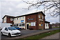
DN17 2EQ is a small area where 45% of properties are owner-occupied, with houses forming the predominant accommodation type. This suggests a market skewed towards family homes rather than high-density housing or rental properties. The relatively low home ownership rate may indicate a significant proportion of rental properties, though specific data on rental availability is not provided. The area’s compact size means property choices are limited to the immediate vicinity, which could be a consideration for buyers seeking more variety. As houses dominate, the market likely caters to those prioritising space and traditional living arrangements. However, the high population density may mean properties are closely spaced, affecting privacy and outdoor space. For buyers, the focus on owner-occupied homes could imply a stable, long-term community, though the small area size may limit options for those seeking larger or more specialised properties.
House Prices in DN17 2EQ
Showing 18 properties
| Address | Type | Beds | Baths | Last Sale Price | Last Sale Date | |
|---|---|---|---|---|---|---|
| 11 Ferriby Road, Scunthorpe, DN17 2EQ | Detached | 3 | 1 | £89,500 | Apr 2019 | |
| 12 Ferriby Road, Scunthorpe, DN17 2EQ | Semi-detached | 3 | 1 | £88,000 | Mar 2016 | |
| 1 Ferriby Road, Scunthorpe, DN17 2EQ | Semi-detached | 3 | 1 | £80,000 | Jun 2013 | |
| 20 Ferriby Road, Scunthorpe, DN17 2EQ | house | 3 | - | £74,950 | Jul 2011 | |
| 3 Ferriby Road, Scunthorpe, DN17 2EQ | Semi-detached | - | - | £49,000 | May 2006 | |
| 5 Ferriby Road, Scunthorpe, DN17 2EQ | Semi-detached | - | - | £62,000 | Jun 2005 | |
| 2 Ferriby Road, Scunthorpe, DN17 2EQ | Semi-detached | 3 | 1 | £59,500 | May 2004 | |
| 10 Ferriby Road, Scunthorpe, DN17 2EQ | Semi-detached | - | - | - | - | |
| 8 Ferriby Road, Scunthorpe, DN17 2EQ | house | - | - | - | - | |
| 24 Ferriby Road, Scunthorpe, DN17 2EQ | Semi-detached | - | - | - | - |
Energy Efficiency in DN17 2EQ
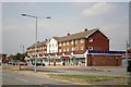
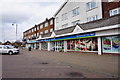
Living in DN17 2EQ offers access to essential retail and transport services within practical reach. Nearby shops include the Lincolnshire Co-operative Co, Heron Riddings, and Tesco Ashby, providing everyday convenience for groceries and general needs. The area’s rail connections to Scunthorpe and Althorpe stations make commuting to work or socialising in larger towns straightforward. While specific details on leisure or green spaces are not provided, the compact layout suggests a focus on functional living rather than expansive recreational areas. The presence of multiple retail options and transport links indicates a practical, community-oriented lifestyle. For residents, the balance of local amenities and regional access means daily life is efficient, though the small area size may limit opportunities for larger-scale leisure activities. The character of DN17 2EQ is defined by its accessibility and the interplay between residential living and nearby urban infrastructure.
Amenities
Schools
| Rank | School | Type | Entry gender | Ages |
|---|
Explore more schools in this area
Go to Schools tabDemographics
The population of DN17 2EQ is predominantly adults aged 30–64, with a median age of 47, indicating a mature, stable community. Home ownership stands at 45%, suggesting a mix of owner-occupied properties and rental stock. The area is characterised by houses rather than flats, reflecting a traditional residential layout. The predominant ethnic group is White, though no specific data on diversity or deprivation levels is provided. The high population density of 192,464 people per square kilometre implies a compact, possibly multi-generational living environment. While this density may foster community interaction, it could also mean limited private space. The age profile suggests a community with established careers and families, potentially influencing local services and amenities. For buyers, understanding this demographic helps gauge the area’s character and long-term stability.
Household Size
Accommodation Type
Tenure
Ethnic Group
Religion
Household Composition
Age
Household Deprivation
NS-SEC
Explore more demographic insights in this area
Go to Demographics tabPlanning
Planning Constraints
- Flood RiskPremium
- Ramsar Wetland SitesPremium
- Area of Outstanding Natural BeautyPremium
- Protected Nature ReservePremium
- Protected WoodlandPremium