Area Overview for DL9 4NT
Photos of DL9 4NT
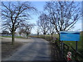
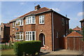
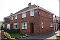
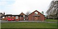
13 photos from this area
Area Information
Key information about the DL9 4NT including its size, population, and administrative classification.
- Area Type
- Postcode
- Area Size
- 2.1 hectares
- Population
- 1800
- Population Density
- 732 people/km²
House Prices in DL9 4NT
55
Properties
£113,563
Average Sold Price
£42,000
Lowest Price
£205,000
Highest Price
Showing 55 properties
| Address | Type | Beds | Baths | Last Sale Price | Last Sale Date | |
|---|---|---|---|---|---|---|
| 34 St Cuthberts Avenue, Colburn, DL9 4NT | house | - | - | £195,000 | Jan 2025 | |
| 11 St Cuthberts Avenue, Colburn, DL9 4NT | house | - | - | £205,000 | Nov 2024 | |
| 36 St Cuthberts Avenue, Colburn, DL9 4NT | house | - | - | £140,000 | Feb 2022 | |
| 3 St Cuthberts Avenue, Colburn, DL9 4NT | house | - | - | £180,000 | Oct 2021 | |
| 14 St Cuthberts Avenue, Colburn, DL9 4NT | Bungalow | - | - | £110,000 | Oct 2020 | |
| 8 St Cuthberts Avenue, Colburn, DL9 4NT | Bungalow | - | - | £119,000 | Sep 2020 | |
| 17 St Cuthberts Avenue, Colburn, DL9 4NT | Semi-detached | 3 | 1 | £136,000 | Jul 2020 | |
| 18 St Cuthberts Avenue, Colburn, DL9 4NT | Semi-detached | 3 | 1 | £132,000 | Nov 2018 | |
| 52 St Cuthberts Avenue, Colburn, DL9 4NT | Semi-detached | 2 | 1 | £120,000 | Jul 2017 | |
| 54 St Cuthberts Avenue, Colburn, DL9 4NT | Bungalow | - | - | £110,000 | Feb 2016 |
Page 1 of 6
Energy Efficiency in DL9 4NT
Amenities
Schools
| Rank | School | Type | Entry gender | Ages |
|---|
Explore more schools in this area
Go to Schools tabDemographics
Household Size
Family (3-5 people)
most common
Accommodation Type
Houses
most common
Tenure
68
majority
Ethnic Group
White
most common
Religion
N/A
most common
Household Composition
N/A
most common
Age
47
median
Adults (30-64 years)
most common
Household Deprivation
N/A
with no deprivation
NS-SEC
25
in Lower managerial occupations
Explore more demographic insights in this area
Go to Demographics tabPlanning
Planning Constraints
- Flood RiskPremium
- Ramsar Wetland SitesPremium
- Area of Outstanding Natural BeautyPremium
- Protected Nature ReservePremium
- Protected WoodlandPremium