Area Overview for BD7 4AX
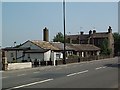
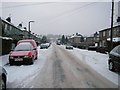
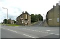
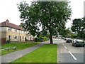
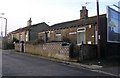
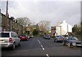
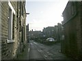
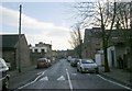
Photos of BD7 4AX
Area Information
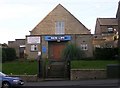
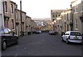
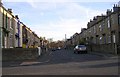
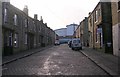
Living in BD7 4AX means being part of a compact, historically rich residential cluster in the heart of Bradford, West Yorkshire. The area covers 655 m² and is home to 1,798 people, making it one of the most densely populated places in England. Despite its small size, BD7 4AX sits within the Great Horton conservation area, a ward with roots stretching back to the Saxon period. The area’s character is defined by a blend of 17th- to 19th-century buildings, including listed structures like Hall’s House and Horton Park, alongside modern urban development. Residents are within 2.5 miles of Bradford city centre, offering easy access to cultural and commercial hubs. The community is predominantly Asian, with a median age of 47, reflecting a mature demographic. Daily life here is shaped by proximity to retail, rail links, and historic parks, though the high population density means space is limited. For those seeking a mix of heritage and convenience, BD7 4AX offers a unique slice of Bradford’s evolving urban fabric.
- Area Type
- Postcode
- Area Size
- 655 m²
- Population
- 1798
- Population Density
- 6300 people/km²
The property market in BD7 4AX is characterised by a 40% home ownership rate, with houses being the primary accommodation type. This suggests a mix of owner-occupied and rental properties, though the small area size means the housing stock is limited. The conservation area designation implies stricter planning controls, which may influence property values and development opportunities. For buyers, the focus on houses rather than flats or apartments could appeal to those seeking family-friendly homes. However, the high population density (2.7 million per km²) raises questions about space and privacy, particularly in a small postcode area. Proximity to Bradford’s transport links and amenities may offset these concerns, but the market’s compact nature means competition for properties is likely. Buyers should consider the balance between historic character and practical living space in this tightly defined postcode.
House Prices in BD7 4AX
No properties found in this postcode.
Energy Efficiency in BD7 4AX
Life in BD7 4AX is shaped by its proximity to retail hubs, historic sites, and green spaces. The area’s five retail venues, including Tesco Bradford and Aldi Clayton, provide essential shopping and dining options, while five rail stations ensure easy access to regional transport. Nearby Horton Park, opened in 1878, offers a public space for leisure and recreation, reflecting the area’s conservation status. The Great Horton Conservation Area, with its 17th- to 19th-century buildings, adds character to daily life, though the high population density means communal spaces are shared. Residents benefit from a compact, walkable environment, with historic landmarks like Hall’s House and the Moravian Chapel nearby. While the area’s small size limits expansion, the mix of heritage and modern amenities creates a unique lifestyle for those valuing both convenience and historical significance.
Amenities
Schools
Residents of BD7 4AX have access to several primary schools, including Brackenhill Primary School, which holds a Good Ofsted rating, and St Oswald’s Church of England Primary Academy, rated Satisfactory. Great Horton Middle School, also listed as primary, and St Oswald’s CofE Primary School provide additional options for younger children. Ummid Independent School, a special needs institution, adds diversity to the educational landscape. The concentration of primary schools suggests a family-friendly environment, though the absence of secondary schools means students may need to travel to nearby areas. The mix of state and independent provision allows parents to choose between mainstream education and specialist support, reflecting the area’s varied community needs. However, the ratings indicate some schools require improvement, which could be a consideration for families prioritising academic standards.
| Rank | School | Type | Entry gender | Ages |
|---|
Explore more schools in this area
Go to Schools tabDemographics
The population of BD7 4AX is 1,798, with a median age of 47, indicating a community skewed towards middle-aged and older residents. The most common age group is adults aged 30–64, suggesting a stable, established population. Home ownership stands at 40%, meaning 60% of households are likely renters, reflecting a mix of owner-occupied and rental properties. The predominant accommodation type is houses, which is unusual for a high-density area, hinting at a focus on single-family homes. The predominant ethnic group is Asian, which shapes the cultural and social dynamics of the area. While specific deprivation data is not provided, the high population density and reliance on rental housing may indicate challenges in housing affordability. However, the presence of historic buildings and conservation status suggests a community invested in preserving local heritage alongside modern living needs.
Household Size
Accommodation Type
Tenure
Ethnic Group
Religion
Household Composition
Age
Household Deprivation
NS-SEC
Explore more demographic insights in this area
Go to Demographics tabPlanning
Planning Constraints
- Flood RiskPremium
- Ramsar Wetland SitesPremium
- Area of Outstanding Natural BeautyPremium
- Protected Nature ReservePremium
- Protected WoodlandPremium