Area Overview for BD7 3PN
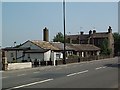
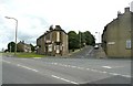
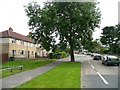
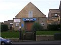
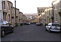
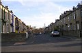
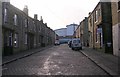
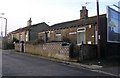
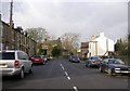
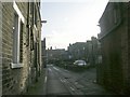
Photos of BD7 3PN


Area Information
Living in BD7 3PN means inhabiting a compact, high-density residential cluster in the heart of Great Horton, a historic ward within Bradford, West Yorkshire. The area spans 2,328 square metres and is home to 1,862 people, creating a densely populated environment where community interactions are frequent. This postcode falls within a conservation area that preserves 17th- to 19th-century architecture, including listed buildings like Hall’s House and Horton Park, a public space opened in 1878. The area’s history is steeped in Saxon-era settlements and 19th-century industrial growth, including cotton mills and religious sites. Today, it balances urban living with historic charm, offering proximity to Bradford’s city centre and rail networks. The demographic profile suggests a mix of families and young professionals, with a median age of 22 but a majority of residents aged 30–64. While broadband connectivity is excellent, a medium crime risk score of 52 means residents should remain vigilant. This area suits those seeking a compact, historically rich environment with practical amenities nearby.
- Area Type
- Postcode
- Area Size
- 2328 m²
- Population
- 1862
- Population Density
- 8705 people/km²
The property market in BD7 3PN is characterised by a 58% home ownership rate, with houses forming the primary accommodation type. This suggests a mix of owner-occupied properties and rental units, though the exact proportion of the latter is not specified. The high population density—799,899 people per square kilometre—means the area’s housing stock is limited to a small footprint, likely centred around terraced or semi-detached homes typical of historic conservation areas. Given the compact size of the postcode, property availability is constrained, and buyers should consider proximity to shared amenities like Horton Park and rail links. The presence of listed buildings and conservation area status may influence property values, with historic features potentially appealing to buyers seeking character. However, the high density and limited space may make this area more suitable for those prioritising convenience over expansive living quarters.
House Prices in BD7 3PN
Showing 19 properties
| Address | Type | Beds | Baths | Last Sale Price | Last Sale Date | |
|---|---|---|---|---|---|---|
| 77 Ewart Street, Great Horton, Bradford, BD7 3PN | Terraced | 2 | 1 | £92,500 | Aug 2024 | |
| 76 Ewart Street, Great Horton, Bradford, BD7 3PN | Terraced | 2 | 1 | £70,500 | Oct 2022 | |
| 82 Ewart Street, Great Horton, Bradford, BD7 3PN | house | - | - | £60,000 | Sep 2021 | |
| 75 Ewart Street, Great Horton, Bradford, BD7 3PN | Terraced | 2 | 1 | £69,000 | Jul 2021 | |
| 80 Ewart Street, Great Horton, Bradford, BD7 3PN | house | - | - | £65,000 | May 2021 | |
| 64 Ewart Street, Great Horton, Bradford, BD7 3PN | house | - | - | £76,000 | Nov 2020 | |
| 73 Ewart Street, Great Horton, Bradford, BD7 3PN | house | - | - | £35,000 | Jun 2019 | |
| 68 Ewart Street, Great Horton, Bradford, BD7 3PN | house | 5 | 1 | £61,000 | Apr 2019 | |
| 65 Ewart Street, Great Horton, Bradford, BD7 3PN | house | - | - | £59,000 | May 2011 | |
| 79 Ewart Street, Great Horton, Bradford, BD7 3PN | Terraced | 2 | 1 | £48,000 | Apr 2009 |
Energy Efficiency in BD7 3PN
The lifestyle in BD7 3PN is shaped by its proximity to practical amenities and historic spaces. Nearby retail options include Tesco Bradford, Aldi Clayton, and Heron Clayton, offering everyday shopping needs. The area’s rail links, such as Bradford Interchange Railway Station, provide access to urban hubs, while Horton Park—a public space established in 1878—offers greenery and recreational opportunities. The conservation area’s listed buildings and 19th-century industrial heritage add cultural depth to daily life. Though the area is compact, the mix of retail, transport, and green spaces creates a functional environment. However, the high population density may mean limited private outdoor space, requiring residents to rely on shared public amenities for leisure.
Amenities
Schools
Residents of BD7 3PN have access to three primary schools within the vicinity: Southmere Primary School and two instances of Southmere Primary Academy, one of which holds an Ofsted rating of ‘good’. These schools cater to young families, though no secondary schools are listed in the data. The presence of two primary schools with one receiving a ‘good’ rating suggests a range of educational options, though parents may need to look beyond the immediate area for secondary schooling. The concentration of primary schools indicates a focus on early education, which could be advantageous for families with young children. However, the lack of information on secondary schools means prospective buyers should investigate further to ensure alignment with long-term educational needs.
| Rank | School | Type | Entry gender | Ages |
|---|
Explore more schools in this area
Go to Schools tabDemographics
BD7 3PN’s population of 1,862 is concentrated in a 2,328-square-metre area, resulting in a density of 799,899 people per square kilometre—far exceeding national averages. The median age is 22, but the most common age range is 30–64, indicating a core of working-age adults. Home ownership rates stand at 58%, with houses being the predominant accommodation type. The area’s predominant ethnic group is Asian_total, reflecting a culturally diverse community. This demographic profile suggests a mix of long-term residents and younger households, though the high density may contribute to a sense of shared space. The absence of specific deprivation data means quality of life factors like access to services and green spaces must be inferred from the area’s amenities, such as Horton Park and nearby retail hubs. The combination of historic architecture and modern connectivity creates a unique living environment, though the compact size may limit private outdoor space.
Household Size
Accommodation Type
Tenure
Ethnic Group
Religion
Household Composition
Age
Household Deprivation
NS-SEC
Explore more demographic insights in this area
Go to Demographics tabPlanning
Planning Constraints
- Flood RiskPremium
- Ramsar Wetland SitesPremium
- Area of Outstanding Natural BeautyPremium
- Protected Nature ReservePremium
- Protected WoodlandPremium