Area Overview for BD7 2LF
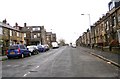
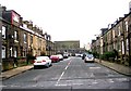
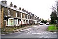
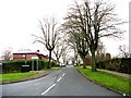
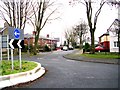
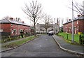
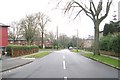
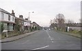
Photos of BD7 2LF
Area Information
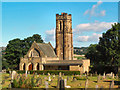
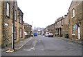
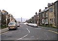
Living in BD7 2LF means inhabiting a compact, high-density urban enclave within the City of Bradford. This postcode covers just 1.7 hectares, housing 2,824 people in a tightly packed residential cluster. Situated approximately 2.5 miles from Bradford city centre, it lies within the historic Great Horton Conservation Area, where 17th- to 19th-century buildings coexist with modern housing. The area’s character is shaped by its industrial past, with remnants like Horton Park (opened 1878) and listed buildings such as Hall’s House and the Old Bell Chapel. Daily life here balances proximity to urban amenities with a preserved historic core, making it ideal for those seeking a blend of heritage and convenience. The ward’s population includes a significant proportion of adults aged 30-64, reflecting a community rooted in stability and routine. With rail links to Bradford’s transport hubs and retail options within walking distance, BD7 2LF offers a self-contained yet connected lifestyle.
- Area Type
- Postcode
- Area Size
- 1.7 hectares
- Population
- 2824
- Population Density
- 9496 people/km²
The property market in BD7 2LF is characterised by a high proportion of owner-occupied homes, with 64% of residents owning their properties. The accommodation type is predominantly houses, which is unusual for a high-density urban area, suggesting a mix of detached and semi-detached housing. This contrasts with the typical high-rise or terraced structures found in similar postcode areas. The limited area size (1.7 hectares) means the housing stock is constrained, with properties likely concentrated in the historic conservation area. Buyers should consider the proximity to Bradford’s urban sprawl, where additional housing options may be available. The presence of listed buildings and historic infrastructure adds value for those prioritising architectural heritage, though it may also impose planning restrictions. For first-time buyers, the market’s focus on owner-occupation and family homes could make it challenging to find rental properties, necessitating exploration of nearby wards.
House Prices in BD7 2LF
Showing 5 properties
| Address | Type | Beds | Baths | Last Sale Price | Last Sale Date | |
|---|---|---|---|---|---|---|
| 123 Spencer Road, Bradford, BD7 2LF | house | - | - | £80,000 | Aug 2012 | |
| 125 Spencer Road, Bradford, BD7 2LF | house | - | - | £87,000 | Jul 2010 | |
| 127 Spencer Road, Bradford, BD7 2LF | house | - | - | £80,000 | Aug 2007 | |
| Jns Motor Spares, Ground And First Floor Offices, 77 Spencer Road, Bradford, BD7 2LF | Office | - | - | - | - | |
| 121 Spencer Road, Bradford, BD7 2LF | house | - | - | - | - |
Energy Efficiency in BD7 2LF
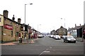
Life in BD7 2LF is defined by proximity to essential amenities and a compact urban layout. Retail options include Tesco Bradford, Aldi Clayton, and Heron Clayton, offering everyday shopping within walking distance. The area’s rail stations connect residents to Bradford’s transport network, enabling easy access to the city’s cultural and commercial centres. Nearby, Horton Park provides green space for recreation, complementing the historic character of the Great Horton Conservation Area. The presence of listed buildings and 18th-century structures adds a sense of continuity to daily life, blending heritage with modern convenience. While the area’s small size limits local variety, its strategic location ensures residents can enjoy both urban vibrancy and preserved historic elements. The mix of retail, transport, and green space supports a practical, community-focused lifestyle.
Amenities
Schools
The nearest school to BD7 2LF is Al-Markaz Academy, an independent institution. While no Ofsted rating is provided, the presence of an independent school suggests a focus on private education for families in the area. The limited number of schools listed indicates that residents may need to travel beyond BD7 2LF for state-funded options. This could be a consideration for parents prioritising a range of educational choices, as the area’s small size may restrict access to multiple school types. The availability of an independent school, however, aligns with the demographic profile of the area, which includes a significant proportion of adults aged 30-64—likely parents seeking quality education for their children. Families should assess whether Al-Markaz Academy’s offerings meet their needs or whether additional schooling options are required nearby.
| Rank | School | Type | Entry gender | Ages |
|---|
Explore more schools in this area
Go to Schools tabDemographics
The demographic profile of BD7 2LF reveals a community skewed toward middle-aged adults, with the most common age range being 30-64 years. The median age of 22 is notably lower, suggesting a younger population may be present in smaller numbers. Home ownership is strong, with 64% of residents owning their homes, compared to 36% renting. The predominant accommodation type is houses, indicating a mix of family homes and single-occupancy properties. The area’s ethnic composition is dominated by the Asian_total group, reflecting broader trends in Bradford’s demographics. While deprivation data is not explicitly provided, the high population density (168,040 people per km²) and concentration of owner-occupied housing suggest a relatively stable, established community with access to local services. The demographic makeup implies a focus on family-oriented living, supported by nearby amenities and transport links.
Household Size
Accommodation Type
Tenure
Ethnic Group
Religion
Household Composition
Age
Household Deprivation
NS-SEC
Explore more demographic insights in this area
Go to Demographics tabPlanning
Planning Constraints
- Flood RiskPremium
- Ramsar Wetland SitesPremium
- Area of Outstanding Natural BeautyPremium
- Protected Nature ReservePremium
- Protected WoodlandPremium