Area Overview for BD7 2EJ
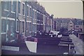
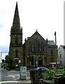
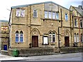
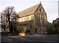
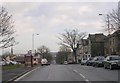
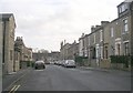
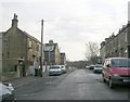
Photos of BD7 2EJ

Area Information
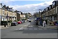
Living in BD7 2EJ means inhabiting a compact, densely populated residential cluster in the heart of Bradford, West Yorkshire. This postcode area, part of the City Ward electoral boundary, sits within the broader Bradford metropolitan district. With a population of 2,109 spread across 6,374 square metres, the area is characterised by high density and a tightly knit community. The proximity to Bradford’s central urban boundaries means residents benefit from easy access to the city’s amenities, including its historic landmarks and cultural hubs. The area’s small size and central location make it ideal for those seeking convenience without sacrificing a sense of local identity. While the population is relatively young, with a median age of 22, the most common age group is adults aged 30–64, suggesting a mix of long-term residents and families. The presence of nearby schools and retail options, combined with strong digital connectivity, positions BD7 2EJ as a practical choice for those prioritising accessibility and urban living.
- Area Type
- Postcode
- Area Size
- 6374 m²
- Population
- 2109
- Population Density
- 12290 people/km²
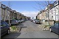
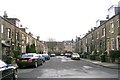
The property market in BD7 2EJ is dominated by owner-occupied homes, with 73% of households owning their properties. This high home ownership rate indicates a stable and established community, where property values may reflect long-term investment. The accommodation type is primarily houses, which contrasts with areas dominated by flats or apartments. Given the small size of the postcode area and its high population density, the housing stock is limited, meaning buyers may need to consider nearby areas for more options. The focus on houses suggests a market suited to families or those seeking larger living spaces. However, the compact nature of BD7 2EJ means that property availability is constrained, potentially leading to competitive conditions for buyers. This dynamic positions the area as a niche market, where demand is driven by proximity to urban amenities and strong digital connectivity.
House Prices in BD7 2EJ
Showing 41 properties
| Address | Type | Beds | Baths | Last Sale Price | Last Sale Date | |
|---|---|---|---|---|---|---|
| 201 Legrams Lane, Bradford, BD7 2EJ | house | - | - | £130,000 | Jul 2025 | |
| 245 Legrams Lane, Bradford, BD7 2EJ | Terraced | 4 | 1 | £135,000 | Aug 2022 | |
| 257 Legrams Lane, Bradford, BD7 2EJ | Terraced | - | - | £130,000 | Sep 2021 | |
| 249 Legrams Lane, Bradford, BD7 2EJ | house | - | - | £33,500 | Sep 2019 | |
| 259 Legrams Lane, Bradford, BD7 2EJ | Terraced | 4 | 2 | £128,000 | Jun 2019 | |
| 205 Legrams Lane, Bradford, BD7 2EJ | house | - | - | £120,000 | Jan 2019 | |
| 221 Legrams Lane, Bradford, BD7 2EJ | Terraced | 4 | 1 | £135,000 | Jul 2018 | |
| 207 Legrams Lane, Bradford, BD7 2EJ | Terraced | 4 | - | £125,000 | Jul 2016 | |
| 261 Legrams Lane, Bradford, BD7 2EJ | house | 3 | - | £95,000 | Jul 2009 | |
| 227 Legrams Lane, Bradford, BD7 2EJ | house | - | - | £55,000 | Jan 2007 |
Energy Efficiency in BD7 2EJ
The lifestyle in BD7 2EJ is shaped by its proximity to essential amenities, including retail outlets and transport hubs. Within practical reach are major supermarkets such as Asda Bradford, Morrisons Scholemoor, and Tesco Bradford, offering convenience for daily shopping needs. The area’s compact layout ensures that these venues are easily accessible on foot or by short journeys. Rail connectivity is robust, with multiple stations providing access to Bradford’s broader transport network, including links to Leeds and Manchester. This accessibility supports both commuting and leisure activities. The presence of nearby schools and the high population density contribute to a lively community atmosphere, though the limited space means amenities are concentrated rather than spread out. For residents, this means a mix of practical convenience and the potential for a dynamic, urban lifestyle with minimal travel time to key services.
Amenities
Schools
Residents of BD7 2EJ have access to several primary schools, including Horton Grange Primary School and Farnham Primary School, both of which hold an Ofsted rating of ‘good’. Waverley Middle School is also listed, though its rating is not specified. The presence of multiple primary schools within close proximity suggests a well-supported educational environment for families with young children. The ‘good’ Ofsted ratings for two of the schools indicate a standard of education that meets or exceeds national benchmarks, which is a key consideration for homebuyers prioritising quality schooling. The concentration of primary schools in the area may also reflect the community’s demographic focus on families. While no secondary schools are listed, the availability of primary education options ensures that children can begin their schooling in the immediate vicinity, reducing the need for long commutes.
| Rank | School | Type | Entry gender | Ages |
|---|
Explore more schools in this area
Go to Schools tabDemographics
The community in BD7 2EJ is predominantly composed of adults aged 30–64, with a median age of 22, indicating a balance between younger and older residents. Home ownership rates are high at 73%, reflecting a stable housing market where 73% of households own their properties. The accommodation type is primarily houses, suggesting a mix of family homes and more spacious living arrangements. The predominant ethnic group is Asian, which shapes the area’s cultural and social fabric. With a population density of 330,858 people per square kilometre, the area is exceptionally crowded, which can influence daily life, from public transport use to community interactions. While this density may foster a vibrant local environment, it also highlights the need for efficient infrastructure to manage demand. The demographic profile suggests a community focused on family life, with a strong emphasis on stability and long-term residency.
Household Size
Accommodation Type
Tenure
Ethnic Group
Religion
Household Composition
Age
Household Deprivation
NS-SEC
Explore more demographic insights in this area
Go to Demographics tabPlanning
Planning Constraints
- Flood RiskPremium
- Ramsar Wetland SitesPremium
- Area of Outstanding Natural BeautyPremium
- Protected Nature ReservePremium
- Protected WoodlandPremium