Area Overview for BD7 1NA
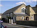
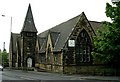
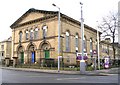
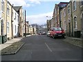
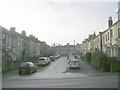
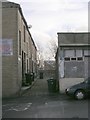
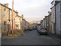
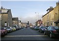
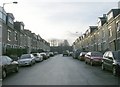
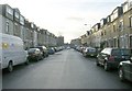
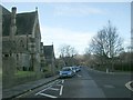
Photos of BD7 1NA

Area Information
BD7 1NA is a compact residential postcode in the heart of Bradford, West Yorkshire, encompassing a small cluster of homes within the City Ward. With a population of 2051 spread across 6821 square metres, the area is densely populated, reflecting the urban character of central Bradford. This postcode falls within the broader Bradford metropolitan area, a historic city known for its cultural and industrial heritage. Daily life here is shaped by proximity to the city’s core, with easy access to transport networks and local amenities. The area’s demographic profile suggests a mix of young adults and middle-aged residents, with a median age of 22, though the most common age range is 30–64. The predominant ethnic group is Asian, contributing to the area’s cultural diversity. While the population density is exceptionally high, the small footprint of BD7 1NA means residents live in close proximity to one another, fostering a tightly knit community. The area’s compact nature makes it ideal for those prioritising convenience and accessibility, though the high density may impact living space per person.
- Area Type
- Postcode
- Area Size
- 6821 m²
- Population
- 2051
- Population Density
- 7622 people/km²
The property market in BD7 1NA is characterised by a low home ownership rate of 40%, suggesting that the area is predominantly a rental market. This contrasts with the typical urban trend of higher ownership, indicating a reliance on private landlords or housing associations. The accommodation type is primarily houses, which is notable in a densely populated postcode. This mix of house types may cater to families or individuals seeking more space than typical flats. Given the small area and high population density, the housing stock is likely limited, potentially increasing competition for properties. Buyers should consider that the market may be constrained by the area’s size, with limited scope for new developments. The prevalence of rental properties also means that long-term ownership could be challenging, requiring careful consideration of local landlord policies and tenancy laws.
House Prices in BD7 1NA
No properties found in this postcode.
Energy Efficiency in BD7 1NA
The lifestyle in BD7 1NA is shaped by its proximity to essential amenities. Within practical reach are five retail venues, including Asda Bradford and Tesco Bradford, offering everyday shopping needs. The presence of multiple railway stations ensures easy access to public transport, enhancing mobility for work, leisure, and travel. While the area lacks detailed information on parks or leisure facilities, the density of retail and transport options suggests a focus on convenience over expansive recreational spaces. The compact nature of the area means residents can access services without long commutes, though the limited green spaces may be a consideration for those prioritising outdoor activities. The combination of retail, transport, and proximity to the city centre creates a practical, urban lifestyle suited to those valuing accessibility.
Amenities
Schools
The nearest school to BD7 1NA is Copthorne Primary School, a primary school with an Ofsted rating of outstanding. This single school serves the area’s primary education needs, offering a high standard of teaching and facilities. The absence of secondary schools in the immediate vicinity means families may need to travel to nearby districts for secondary education. The presence of an outstanding primary school is a significant advantage, particularly for parents prioritising quality education. However, the limited range of school types suggests that families may need to plan for additional travel or consider the availability of private schooling. The school’s rating indicates a strong foundation for early education, which can be a key factor in deciding to live in BD7 1NA.
| Rank | School | Type | Entry gender | Ages |
|---|
Explore more schools in this area
Go to Schools tabDemographics
The demographic profile of BD7 1NA reveals a population skewed towards adults aged 30–64, despite a median age of 22. This suggests a community where younger residents may be students or newly established professionals, while older adults form the majority. Home ownership in the area is relatively low at 40%, indicating a rental-dominated market. The accommodation type is primarily houses, which is uncommon in high-density urban areas, suggesting a mix of family homes and smaller properties. The predominant ethnic group is Asian, reflecting broader trends in Bradford’s population. With 300,710 people per square kilometre, the area is among the most densely populated in England, which can influence the character of daily life. While this density may limit private space, it also ensures proximity to services and social networks. The demographic data underscores a community that is both diverse and dynamic, shaped by its urban setting and cultural makeup.
Household Size
Accommodation Type
Tenure
Ethnic Group
Religion
Household Composition
Age
Household Deprivation
NS-SEC
Explore more demographic insights in this area
Go to Demographics tabPlanning
Planning Constraints
- Flood RiskPremium
- Ramsar Wetland SitesPremium
- Area of Outstanding Natural BeautyPremium
- Protected Nature ReservePremium
- Protected WoodlandPremium