Area Overview for BD21 1AW
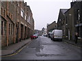
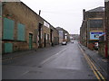
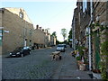
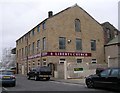
Photos of BD21 1AW

Area Information
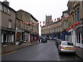
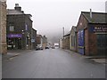
Living in BD21 1AW means inhabiting a small, densely populated residential cluster in the town of Keighley, West Yorkshire. This area covers just 1.3 hectares, yet it is home to 1,535 people, translating to a population density of 122,617 people per square kilometre. The postcode sits within a historic market town that evolved from a rural settlement into a modern hub, with roots tracing back to the 12th century. Daily life here is shaped by proximity to retail, transport, and community infrastructure. Residents benefit from nearby supermarkets like Morrisons and Co-op, as well as multiple rail stations, including Keighley Railway Station. The area’s compact size means amenities are within practical reach, though the high density reflects a mix of long-standing residents and those drawn to the town’s established character. BD21 1AW is not a sprawling suburb but a tightly knit postcode where the past and present coexist, with the town’s industrial heritage still influencing its identity.
- Area Type
- Postcode
- Area Size
- 1.3 hectares
- Population
- 1535
- Population Density
- 122617 people/km²
The property market in BD21 1AW is characterised by a high proportion of rental properties, with just 19% of homes owned by residents. The accommodation type is predominantly flats, which aligns with the area’s compact size and density. This suggests a housing stock tailored to smaller households or individuals seeking affordability over spaciousness. Given the small area size and limited land, the surrounding region likely offers similar property types, though specific details about nearby areas are not provided. For buyers, the market may present limited opportunities for owner-occupation, with flats being the primary option. The high rental rate could indicate a demand for short-term or investment properties, but prospective buyers should consider the area’s constraints and whether the housing stock meets their long-term needs.
House Prices in BD21 1AW
No properties found in this postcode.
Energy Efficiency in BD21 1AW
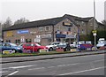
Residents of BD21 1AW have access to a range of amenities within practical reach. Retail options include Morrisons Daily, Co-op Broomhill, and Morrisons Eastwood, offering everyday shopping needs. The area’s transport links connect to metro stations like Ingrow West and rail stations such as Keighley Railway Station, enabling easy travel to nearby towns. While the data does not specify parks or leisure facilities, the proximity to Keighley—a town with historical markets and industrial heritage—suggests cultural and social activities may be available in the wider area. The combination of retail, transport, and historical context creates a lifestyle that balances convenience with the character of a traditional market town.
Amenities
Schools
| Rank | School | Type | Entry gender | Ages |
|---|
Explore more schools in this area
Go to Schools tabDemographics
The community in BD21 1AW is predominantly composed of adults aged 30–64, with a median age of 47. This suggests a population skewed toward middle-aged and older residents, likely including professionals, retirees, and families. Home ownership is low, with only 19% of households owning their homes, indicating a rental market that dominates. The accommodation type is primarily flats, reflecting a housing stock suited to smaller households or those prioritising convenience over space. The predominant ethnic group is White, though the data does not specify further diversity metrics. The high population density—over 122,000 people per square kilometre—suggests a compact, possibly urbanised environment where shared spaces and communal living are common. This density may influence local services and infrastructure, with amenities designed to meet the needs of a concentrated population.
Household Size
Accommodation Type
Tenure
Ethnic Group
Religion
Household Composition
Age
Household Deprivation
NS-SEC
Explore more demographic insights in this area
Go to Demographics tabPlanning
Planning Constraints
- Flood RiskPremium
- Ramsar Wetland SitesPremium
- Area of Outstanding Natural BeautyPremium
- Protected Nature ReservePremium
- Protected WoodlandPremium