Area Overview for BD15 8AE
Photos of BD15 8AE
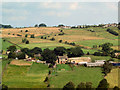
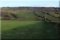

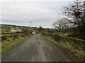
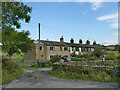
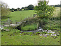

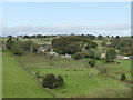
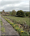
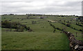
37 photos from this area
Area Information
Key information about the BD15 8AE including its size, population, and administrative classification.
- Area Type
- Postcode
- Area Size
- 47.6 hectares
- Population
- 1414
- Population Density
- 287 people/km²
House Prices in BD15 8AE
30
Properties
£189,714
Average Sold Price
£55,950
Lowest Price
£390,000
Highest Price
Showing 30 properties
| Address | Type | Beds | Baths | Last Sale Price | Last Sale Date | |
|---|---|---|---|---|---|---|
| Brydene, Yew Tree Lane, Bradford, BD15 8AE | Semi-detached | 3 | 2 | £300,000 | Aug 2019 | |
| Aldersbrook, 38-40 Allerton Upper Green, Bradford, BD15 8AE | Detached | 3 | 2 | £350,000 | Aug 2019 | |
| 20 Allerton Upper Green, Bradford, BD15 8AE | house | 2 | 1 | £89,000 | Nov 2018 | |
| 24 Allerton Upper Green, Bradford, BD15 8AE | house | - | - | £139,950 | Jul 2017 | |
| Lower Pikeley Farm, Yew Tree Lane, Bradford, BD15 8AE | Detached | 5 | 2 | £390,000 | Mar 2017 | |
| Yew Tree Farm, Yew Tree Lane, Bradford, BD15 8AE | Land | 4 | - | £325,000 | Oct 2016 | |
| 46 Allerton Upper Green, Bradford, BD15 8AE | Terraced | 2 | 1 | £132,000 | May 2007 | |
| 22 Allerton Upper Green, Bradford, BD15 8AE | Terraced | 2 | 1 | £133,000 | Nov 2006 | |
| 28 Allerton Upper Green, Bradford, BD15 8AE | Terraced | - | - | £99,950 | Sep 2001 | |
| 18 Allerton Upper Green, Bradford, BD15 8AE | Terraced | - | - | £72,000 | Feb 1999 |
Page 1 of 3
Energy Efficiency in BD15 8AE
Amenities
Schools
| Rank | School | Type | Entry gender | Ages |
|---|
Explore more schools in this area
Go to Schools tabDemographics
Household Size
Two person
most common
Accommodation Type
Houses
most common
Tenure
87
majority
Ethnic Group
White
most common
Religion
N/A
most common
Household Composition
N/A
most common
Age
47
median
Adults (30-64 years)
most common
Household Deprivation
N/A
with no deprivation
NS-SEC
38
in Lower managerial occupations
Explore more demographic insights in this area
Go to Demographics tabPlanning
Planning Constraints
- Flood RiskPremium
- Ramsar Wetland SitesPremium
- Area of Outstanding Natural BeautyPremium
- Protected Nature ReservePremium
- Protected WoodlandPremium