Area Overview for WV16 4HT
Photos of WV16 4HT

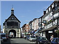

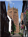
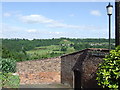

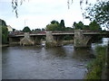
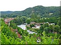

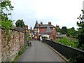
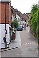
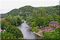
100 photos from this area
Area Information
Key information about the WV16 4HT including its size, population, and administrative classification.
- Area Type
- Postcode
- Area Size
- 2123 m²
- Population
- 1412
- Population Density
- 1784 people/km²
House Prices in WV16 4HT
50
Properties
£287,364
Average Sold Price
£225,950
Lowest Price
£333,950
Highest Price
Showing 50 properties
| Address | Type | Beds | Baths | Last Sale Price | Last Sale Date | |
|---|---|---|---|---|---|---|
| 30, Mortimer Lodge, Innage Lane, Bridgnorth, WV16 4HT | Flat | 2 | 1 | £285,000 | Jun 2025 | |
| 42, Mortimer Lodge, Innage Lane, Bridgnorth, WV16 4HT | Flat | 2 | 2 | £333,950 | Aug 2022 | |
| 7, Mortimer Lodge, Innage Lane, Bridgnorth, WV16 4HT | Flat | - | - | £315,950 | May 2022 | |
| 5, Mortimer Lodge, Innage Lane, Bridgnorth, WV16 4HT | Flat | - | - | £320,950 | May 2022 | |
| 50, Mortimer Lodge, Innage Lane, Bridgnorth, WV16 4HT | Flat | - | - | £255,950 | Mar 2022 | |
| 45, Mortimer Lodge, Innage Lane, Bridgnorth, WV16 4HT | Flat | - | - | £227,950 | Mar 2022 | |
| 22, Mortimer Lodge, Innage Lane, Bridgnorth, WV16 4HT | Flat | 2 | 2 | £322,450 | Feb 2022 | |
| 21, Mortimer Lodge, Innage Lane, Bridgnorth, WV16 4HT | Flat | 1 | 1 | £317,950 | Feb 2022 | |
| 15, Mortimer Lodge, Innage Lane, Bridgnorth, WV16 4HT | Retirement | 1 | 1 | £250,950 | Feb 2022 | |
| 25, Mortimer Lodge, Innage Lane, Bridgnorth, WV16 4HT | Flat | - | - | £225,950 | Feb 2022 |
Page 1 of 5
Energy Efficiency in WV16 4HT
Amenities
Schools
| Rank | School | Type | Entry gender | Ages |
|---|
Explore more schools in this area
Go to Schools tabDemographics
Household Size
Two person
most common
Accommodation Type
Houses
most common
Tenure
69
majority
Ethnic Group
White
most common
Religion
N/A
most common
Household Composition
N/A
most common
Age
47
median
Adults (30-64 years)
most common
Household Deprivation
N/A
with no deprivation
NS-SEC
40
in Lower managerial occupations
Explore more demographic insights in this area
Go to Demographics tabPlanning
Planning Constraints
- Flood RiskPremium
- Ramsar Wetland SitesPremium
- Area of Outstanding Natural BeautyPremium
- Protected Nature ReservePremium
- Protected WoodlandPremium