Area Overview for Wroxeter and Uppington
Photos of Wroxeter and Uppington
Area Information
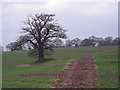
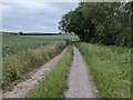
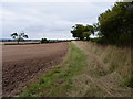
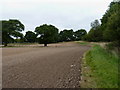
Wroxeter and Uppington sits as a distinct civil parish in England, covering an area of 27.0 km². This location offers a specific type of rural lifestyle defined by its historical identity and small geographical footprint. The village is characteristically quiet, situated away from the noise of larger urban centres. You will find that daily life here revolves around local routines rather than commuting through busy intersections. The landscape includes significant areas designated within an Area of Outstanding Natural Beauty, which brings planning constraints to building or expansion. This means that while the scenery is preserved, development is strictly limited. The parish maintains a strong sense of place without the congestion of a larger town. Residents enjoy a setting where the environment remains intact due to its protected status. Living in Wroxeter and Uppington requires an appreciation for tranquility and natural surroundings. The area does not offer the amenities of a city but provides a stable, low-density environment. You should approach this location if you prioritise space and a steady pace over modern convenience. The 27.0 km² size ensures that the community feels contained and manageable.
- Area Type
- Parish
- Area Size
- 27.0 km²
- Population
- Not available
- Population Density
- Not available
Demographics
The community living in Wroxeter and Uppington possesses a very specific age profile with a median age of 70. This figure indicates that the population is predominantly older adults, suggesting a retirement settlement or an area with a long-established resident base. You will notice that the most common age range falls entirely within the older demographics, which shapes the local culture and services. Approximately 67% of households own their homes outright, highlighting a strong trend towards home ownership over renting. This high rate of ownership correlates with the older population, as long-term residents often own their properties. Accommodation types generally reflect this ownership pattern, favouring detached or semi-detached housing suitable for families who have empty-nested. The area shows little indication of recent migration or a young professional influx. You can expect a stable community where long-term residents remain. There is no data provided regarding specific ethnic diversity or religious breakdown, but the demographic structure points towards a traditional British village population. The social atmosphere will centre on activities relevant to older adults rather than youth-centric entertainment or schools.
Household Size
Accommodation Type
Tenure
Ethnic Group
Religion
Household Composition
Age
Household Deprivation
NS-SEC
Explore more demographic insights in this area
Go to Demographics tabPlanning
Planning Constraints
- Flood RiskLocked
- Ramsar Wetland SitesLocked
- Area of Outstanding Natural BeautyLocked
- Protected Nature ReserveLocked
- Protected WoodlandLocked
- Crime RiskLocked