Area Overview for WR12 7RA
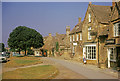
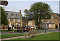
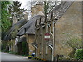
Photos of WR12 7RA
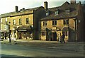

![Broadway footpath [1] in WR12 7RA](https://images.propbar.co.uk/images/geograph/17/21/1721866_120.jpg)
![Broadway footpath [6] in WR12 7RA](https://images.propbar.co.uk/images/geograph/17/21/1721887_120.jpg)


100 photos from this area
Area Information
Key information about the WR12 7RA including its size, population, and administrative classification.
- Area Type
- Postcode
- Area Size
- 5.2 hectares
- Population
- 1604
- Population Density
- 1179 people/km²
House Prices in WR12 7RA
55
Properties
£246,341
Average Sold Price
£25,000
Lowest Price
£490,000
Highest Price
Showing 55 properties
| Address | Type | Beds | Baths | Last Sale Price | Last Sale Date | |
|---|---|---|---|---|---|---|
| 25 Averill Close, Broadway, WR12 7RA | Detached | 3 | 1 | £455,000 | Jun 2025 | |
| 10 Averill Close, Broadway, WR12 7RA | house | - | - | £290,000 | Mar 2025 | |
| 45 Averill Close, Broadway, WR12 7RA | Bungalow | 2 | 1 | £400,000 | Sep 2024 | |
| 17 Averill Close, Broadway, WR12 7RA | Bungalow | - | - | £395,000 | Jul 2024 | |
| 48 Averill Close, Broadway, WR12 7RA | Terraced | 3 | - | £306,000 | Jul 2024 | |
| 12 Averill Close, Broadway, WR12 7RA | Detached | 4 | 2 | £490,000 | Jun 2024 | |
| 60 Averill Close, Broadway, WR12 7RA | Terraced | 2 | 1 | £265,000 | Feb 2024 | |
| 16 Averill Close, Broadway, WR12 7RA | Terraced | 2 | 1 | £285,000 | Aug 2023 | |
| 64 Averill Close, Broadway, WR12 7RA | Semi-detached | 3 | 1 | £430,000 | Aug 2023 | |
| 18 Averill Close, Broadway, WR12 7RA | house | - | - | £250,000 | Feb 2023 |
Page 1 of 6
Energy Efficiency in WR12 7RA
Amenities
Schools
| Rank | School | Type | Entry gender | Ages |
|---|
Explore more schools in this area
Go to Schools tabDemographics
Household Size
One person
most common
Accommodation Type
Houses
most common
Tenure
58
majority
Ethnic Group
White
most common
Religion
N/A
most common
Household Composition
N/A
most common
Age
47
median
Adults (30-64 years)
most common
Household Deprivation
N/A
with no deprivation
NS-SEC
34
in Lower managerial occupations
Explore more demographic insights in this area
Go to Demographics tabPlanning
Planning Constraints
- Flood RiskPremium
- Ramsar Wetland SitesPremium
- Area of Outstanding Natural BeautyPremium
- Protected Nature ReservePremium
- Protected WoodlandPremium