Area Overview for WR12 7AE
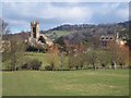
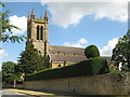
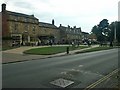
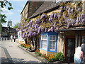
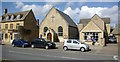
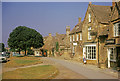
Photos of WR12 7AE
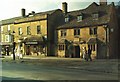
![Broadway footpath [1] in WR12 7AE](https://images.propbar.co.uk/images/geograph/17/21/1721866_120.jpg)
![Broadway footpath [2] in WR12 7AE](https://images.propbar.co.uk/images/geograph/17/21/1721870_120.jpg)
![Broadway footpath [3] in WR12 7AE](https://images.propbar.co.uk/images/geograph/17/21/1721874_120.jpg)
![Broadway footpath [5] in WR12 7AE](https://images.propbar.co.uk/images/geograph/17/21/1721885_120.jpg)
![Broadway footpath [6] in WR12 7AE](https://images.propbar.co.uk/images/geograph/17/21/1721887_120.jpg)
100 photos from this area
Area Information
Key information about the WR12 7AE including its size, population, and administrative classification.
- Area Type
- Postcode
- Area Size
- 11.9 hectares
- Population
- 1878
- Population Density
- 119 people/km²
House Prices in WR12 7AE
35
Properties
£1,021,521
Average Sold Price
£520,000
Lowest Price
£1,795,000
Highest Price
Showing 35 properties
| Address | Type | Beds | Baths | Last Sale Price | Last Sale Date | |
|---|---|---|---|---|---|---|
| 27 Church Street, Broadway, WR12 7AE | Terraced | 2 | 2 | £598,250 | Nov 2023 | |
| Boughs Cottage, 23 Church Street, Broadway, WR12 7AE | house | 3 | - | £925,000 | Sep 2021 | |
| Cowley House, 7 Church Street, Broadway, WR12 7AE | house | - | - | £1,000,000 | Jun 2021 | |
| Battridge Cottage, Church Street, Broadway, WR12 7AE | house | - | - | £1,400,000 | Mar 2021 | |
| Kingfisher House, 15 Church Street, Broadway, WR12 7AE | house | - | - | £695,000 | Oct 2019 | |
| Abbotts Grange, 5 Church Street, Broadway, WR12 7AE | Bungalow | - | - | £650,000 | Oct 2017 | |
| The House On The Green, Church Street, Broadway, WR12 7AE | house | - | - | £1,795,000 | Apr 2017 | |
| Kylsant House, 16 Church Street, Broadway, WR12 7AE | Semi-detached | 8 | - | £1,200,000 | May 2014 | |
| Farnham House, 1 Church Street, Broadway, WR12 7AE | Terraced | - | - | £1,050,000 | Jan 2007 | |
| The Vicarage, Church Street, Broadway, WR12 7AE | house | 4 | - | £675,000 | Jan 2006 |
Page 1 of 4
Energy Efficiency in WR12 7AE
Amenities
Schools
| Rank | School | Type | Entry gender | Ages |
|---|
Explore more schools in this area
Go to Schools tabDemographics
Household Size
Two person
most common
Accommodation Type
Houses
most common
Tenure
82
majority
Ethnic Group
White
most common
Religion
N/A
most common
Household Composition
N/A
most common
Age
47
median
Elderly (65+ years)
most common
Household Deprivation
N/A
with no deprivation
NS-SEC
39
in Lower managerial occupations
Explore more demographic insights in this area
Go to Demographics tabPlanning
Planning Constraints
- Flood RiskPremium
- Ramsar Wetland SitesPremium
- Area of Outstanding Natural BeautyPremium
- Protected Nature ReservePremium
- Protected WoodlandPremium