Area Overview for WR1 2NA
Photos of WR1 2NA
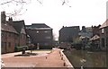
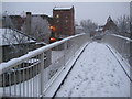


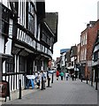
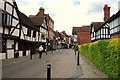


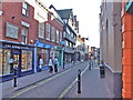
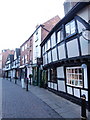
100 photos from this area
Area Information
Key information about the WR1 2NA including its size, population, and administrative classification.
- Area Type
- Postcode
- Area Size
- 9945 m²
- Population
- 1225
- Population Density
- 3451 people/km²
House Prices in WR1 2NA
55
Properties
£147,773
Average Sold Price
£93,500
Lowest Price
£385,000
Highest Price
Showing 55 properties
| Address | Type | Beds | Baths | Last Sale Price | Last Sale Date | |
|---|---|---|---|---|---|---|
| 27A Friar Street, Worcester, WR1 2NA | Flat | 3 | 2 | £385,000 | May 2023 | |
| 71 Friar Street, Worcester, WR1 2NA | Flat | - | - | £132,500 | Oct 2022 | |
| 65 Friar Street, Worcester, WR1 2NA | Flat | - | - | £100,000 | Apr 2022 | |
| 37C Friar Street, Worcester, WR1 2NA | Flat | 2 | 1 | £140,000 | Jun 2021 | |
| 75 Friar Street, Worcester, WR1 2NA | Flat | - | - | £97,000 | Feb 2021 | |
| 51 Friar Street, Worcester, WR1 2NA | Flat | - | - | £126,000 | Jul 2019 | |
| 67 Friar Street, Worcester, WR1 2NA | Flat | 2 | 2 | £240,000 | Dec 2018 | |
| 69 Friar Street, Worcester, WR1 2NA | Flat | - | - | £93,500 | Sep 2017 | |
| 49 Friar Street, Worcester, WR1 2NA | Flat | 1 | 1 | £102,000 | Apr 2017 | |
| 53 Friar Street, Worcester, WR1 2NA | Flat | 1 | 1 | £95,500 | Sep 2016 |
Page 1 of 6
Energy Efficiency in WR1 2NA
Amenities
Schools
| Rank | School | Type | Entry gender | Ages |
|---|
Explore more schools in this area
Go to Schools tabDemographics
Household Size
One person
most common
Accommodation Type
Flats
most common
Tenure
17
majority
Ethnic Group
White
most common
Religion
N/A
most common
Household Composition
N/A
most common
Age
47
median
Adults (30-64 years)
most common
Household Deprivation
N/A
with no deprivation
NS-SEC
25
in Lower managerial occupations
Explore more demographic insights in this area
Go to Demographics tabPlanning
Planning Constraints
- Flood RiskPremium
- Ramsar Wetland SitesPremium
- Area of Outstanding Natural BeautyPremium
- Protected Nature ReservePremium
- Protected WoodlandPremium