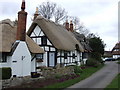
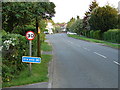
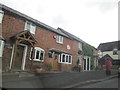
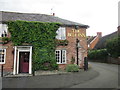
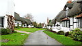
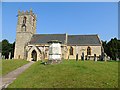
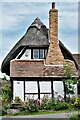
Area Overview for Welford-on-Avon
Photos of Welford-on-Avon


Area Information
Welford-on-Avon is a compact built-up area spanning 1.3 km², nestled in England’s countryside. Its population, though not explicitly stated, reflects a median age of 70, suggesting a community skewed toward older residents. This demographic shape influences the area’s character, with a focus on stability and low turnover. Daily life here is defined by proximity to essential services, including five retail outlets like Co-op Bidford on and Morrisons Wilmcote Stratford-Upon, which cater to local needs. The area’s rail connectivity is robust, with five stations nearby, including Stratford and Wilmcote Railway Station, offering easy access to nearby towns. For families, the Welford-on-Avon Primary School, rated ‘good’ by Ofsted, provides a solid foundation for early education. While the broadband score is low at 27, mobile coverage is strong at 83, ensuring most residents can stay connected. Welford-on-Avon balances rural tranquillity with practical amenities, making it a viable option for those prioritising safety and community over urban vibrancy.
- Area Type
- Built Up Area 250
- Area Size
- 1.3 km²
- Population
- Not available
- Population Density
- Not available
Welford-on-Avon’s amenities include five retail outlets, such as Co-op Bidford on and Morrisons Wilmcote Stratford-Upon, offering everyday shopping convenience. These stores, along with Aldi Snitterfield Stratford-Upon, support local needs without requiring long trips. The area’s rail stations, including Stratford and Wilmcote, provide easy access to broader networks, enhancing connectivity for commuters. While parks and leisure facilities are not detailed in the data, the presence of retail and transport options suggests a lifestyle focused on practicality and community access. The mix of shops and rail links ensures residents can meet daily needs without leaving the area.
Amenities
Schools
The nearest school to Welford-on-Avon is Welford-on-Avon Primary School, a state-funded institution offering education for younger children. It holds a ‘good’ Ofsted rating, reflecting its effectiveness in teaching and student outcomes. The presence of a primary school makes the area appealing to families with young children, though no secondary schools are listed in the data. This suggests that students may need to travel to nearby towns for secondary education. The school’s rating indicates a reliable educational foundation, but families should verify transport links and availability of higher education options in the surrounding region.
| Rank | A + A* % | School | Type | Entry gender | Ages |
|---|---|---|---|---|---|
| 1 | N/A | Welford-on-Avon Primary School | primary | N/A | N/A |
Explore more schools in this area
Go to Schools tabDemographics
The population of Welford-on-Avon has a median age of 70, indicating a predominantly older demographic. The most common age range is listed as ‘Total’, which suggests data aggregation without specific breakdowns. Home ownership is high, with 82% of residents owning their homes, a figure that reflects a stable, long-term community. Household composition and accommodation types are not specified, but the high ownership rate implies a mix of family homes and retirement properties. The area’s demographic profile, while lacking granular detail on diversity or ethnicity, aligns with a mature population seeking established living environments. This age profile may influence local services, with amenities tailored to older residents, such as accessible retail and healthcare. The absence of detailed data on deprivation or diversity means the area’s social fabric remains largely inferred from ownership and age metrics.
Household Size
Accommodation Type
Tenure
Ethnic Group
Religion
Household Composition
Age
Household Deprivation
NS-SEC
Explore more demographic insights in this area
Go to Demographics tabPlanning
Planning Constraints
- Crime RiskLocked